username
X
password
register
for free!
help
 This is likely a great time to hike this trail!  Check out "Preferred" months below, keep in mind this is an estimate. 
  

Mt Franklin Trail - IRNP, MI

Guide 1 Triplog  0 Topics
  5 of 5  
Fav
Wish
1
details
drive
permit
forecast
route  
stats
photos
triplog
topics
location
25 1 0
Statistics
tap row or icons for details
Difficulty 2 of 5
Route Finding 2 of 5
Distance One Way 2 miles
Trailhead Elevation 610 feet
Elevation Gain 531 feet
Accumulated Gain 531 feet
Avg Time One Way 1 hour
Kokopelli Seeds 3.77
 Interest Perennial Creek & Peak
 Backpack Yes
 Dogs not allowed
feature photo
Photos Viewed All MineFollowing
25  2024-08-15
Rock Harbor - Mt Ojibway - Daisy Farm Loop
The_Eagle
Author
author avatar Guides 41
Routes 1,626
Photos 14,983
Trips 2,760 map ( 18,597 miles )
Age 69 Male Gender
Location Far NE Phoenix, Az
Historical Weather
Trailhead Forecast
Radar Map
Expand Map
Preferred Sep, May, Jun, Aug → 7 AM
Sun  6:16am - 7:30pm
Official Route
 
1 Alternative


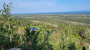
Benjamin was never here other than in name
by The_Eagle

 Likely In-Season! 
The Mt. Franklin Trail provides hikers with a unique blend of scenic beauty, rich history, and diverse wildlife. Starting from the Rock Harbor Trail, this hike takes you through a variety of landscapes, making it one of the most rewarding hikes on the island. it terminates at the Greenstone Ridge Trail. It's another 0.3 miles WSW to reach the actual peak.


As you ascend the trail, you’ll pass through lush forests dominated by balsam fir, white spruce, and paper birch. These trees provide a canopy that shelters the trail, and the underbrush is often teeming with wildflowers and ferns. In this rich environment, you might spot a moose grazing or catch a glimpse of the red fox, which are common on the island. Birdwatchers will also enjoy the chance to see species like the common loon and various woodpeckers, notably American Three-toed Woodpeckers. You will need to cross numerous 12" wide boardwalks that help avoid some of the more muddy and marshy areas and Tobin Creek.
remove free decal offer
The trail climbs steadily until you reach the summit of Mt. Franklin, named after the famous explorer Benjamin Franklin. At 1,060 feet above sea level, the summit offers gorgeous 360 views of the island, Lake Superior, and Canada some 15 miles away. The exposed rock at the summit is a great place to take a break and enjoy the sweeping panorama and cooling breezes.

2024-08-25 The_Eagle


    Check out the Official Route and Triplog.
    Leave No Trace and +Add a Triplog after your hike to support this local community.

    One-Way Notice
    This hike is listed as One-Way.

    When hiking several trails on a single "hike", log it with a generic name that describes the hike. Then link the trails traveled, check out the example.
    WARNING! Hiking and outdoor related sports can be dangerous. Be responsible and prepare for the trip. Study the area you are entering and plan accordingly. Dress for the current and unexpected weather changes. Take plenty of water. Never go alone. Make an itinerary with your plan(s), route(s), destination(s) and expected return time. Give your itinerary to trusted family and/or friends.

     Permit $$
    NPS


     Directions
    or
     Road
    Connector trail - Not Applicable

    To hike
    This is a connector Trail. It can be reached from the Rock Harbor Trail, Tobin Harbor Trail, Greenstone Ridge Trail, or Lane Cove Trail.
    page created by The_Eagle on Aug 25 2024 2:14 pm
     90+° 8am - 6pm kills
    helpcorrectionissue

    end of page marker