username
X
password
register
for free!
help
  This is likely a great time to hike this trail!  Check out "Preferred" months below, keep in mind this is an estimate.
  

Roman Nose Lakes, ID

Guide 1 Triplog  0 Topics
  4.7 of 5  
Fav
Wish
0
details
drive
permit
forecast
route  
stats
photos
triplog
topics
location
15 1 0
Statistics
tap row or icons for details
Difficulty 1.5 of 5
Route Finding 1 of 5
Distance Round Trip 4.35 miles
Trailhead Elevation 5,892 feet
Elevation Gain 353 feet
Accumulated Gain 812 feet
Avg Time Round Trip 2.5 hrs
Kokopelli Seeds 8.41
 Interest Seasonal Waterfall & Perennial Creek
 Backpack No
feature photo
Photos Viewed All MineFollowing
15  2023-06-28 LindaAnn
Author
author avatar Guides 110
Routes 2,246
Photos 8,982
Trips 2,600 map ( 15,998 miles )
Age 45 Female Gender
Location Ahwatukee, AZ
Associated Areas
list map done
Northern Region
Historical Weather
Trailhead Forecast
Radar Map
Expand Map
Preferred Jun, Jul, Aug, Sep
Seasons   Summer to Autumn
Sun  6:09am - 7:20pm
Official Route & 1 Rt
 
0 Alternative


Nine Percent Aquiline Curve
by LindaAnn

  Likely In-Season!
Overview Easy to slightly moderate hike to the three Roman Nose Lakes in the Selkirk Mountains. Camping and swimming are also an option.


Hike The first lake is immediately south of the parking lot and is reached via a handicapped-accessible boardwalk. The boardwalk takes you to two viewpoints along the edge of the lake. There is also a use-trail along the lake and a short trail that heads east to the adjacent campground. After taking in the views of the first lake, retrace your steps along the boardwalk back to the parking lot.
remove free decal offer
The trail to the other two lakes starts on the west side of the parking lot. You will quickly cross a bridge, then head uphill, using some more boardwalks along the way. The trail winds through the trees and granite boulders and is generally easy to travel. After a short distance, the trail splits and is marked with a metal sign. Turn right to head to the lakes (taking the left option utilizes a longer loop that reconnects to the trail in less than a mile). Continuing uphill, views start to open up in most directions. Once again, there is another split in the trail, and again take the right turn to continue up to the lakes (the left turn is the optional loop reconnecting to the main trail). At roughly the high point of the hike, a large granite outcropping appears ahead of you with excellent views to the north.

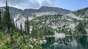
After enjoying those views, the trail splits again--right for Lake Two and left for Lake Three. Take the right spur and drop down to Lake Two, which is fed by a waterfall from Lake Three and discharges (along with Lake One) into the beginning of Caribou Creek. Retrace your steps back up to the junction between the two lakes, then take the other spur over to Lake Three. Lake Three seems to be the largest of the lakes and sits directly below Roman Nose Peak, which sits about 1100' above the lake. It appears the summit of Roman Nose could be reached via a scramble up the west side of the lake, then by following the ridge around to the top. Like the other two lakes, the water is clear and clean and you can see reasonably deep into the lake.

The hike back down to the parking lot is easy and goes by quickly. Be aware of wildlife in the area, which could include moose and bears (black & grizzly). Due to the area's popularity, camping is only permitted at the campground near Lake One, although several fire rings were seen by the lakes and along the trail. Bring bug repellent, especially during the summer months--autumn might not have as many mosquitos.

2023-06-28 LindaAnn


    Check out the Official Route and Triplog.
    Leave No Trace and +Add a Triplog after your hike to support this local community.
    WARNING! Hiking and outdoor related sports can be dangerous. Be responsible and prepare for the trip. Study the area you are entering and plan accordingly. Dress for the current and unexpected weather changes. Take plenty of water. Never go alone. Make an itinerary with your plan(s), route(s), destination(s) and expected return time. Give your itinerary to trusted family and/or friends.

     Permit $$
    FS
    Backpacking camping permits: request 2 weeks in advance


     Directions
    or
     Road
    FR / Jeep Road - Car possible when dry

    To hike
    When dry, any vehicle with medium clearance can reach the trailhead. There are some potholes and rocks that might challenge sedans, but a capable driver would likely be okay, however, some clearance would be better.

    From Sandpoint, head north on US-2/95 approx 23 miles to Old Hwy 95/Deep Creek Loop at the town of Naples. Turn left on Old Hwy 95/Deep Creek Rd and follow it north for 6.30 miles to Lions Den Rd and turn left. Take Lions Den Rd west, then north (don't miss the turn just before the railroad tracks) for 2.10 miles to Snow Creek Rd, which is not well signed, but is just past crossing the bridge over Snow Creek. Turn left on Snow Creek Rd (left fork) which is FS402. Once you turn onto Snow Creek Rd, it is 19 miles of dirt road to the trailhead.

    Take FS402 West for approx 9.5 mi. Left on FS1007 and take it for approx 7.3 mi to Ruby Pass. Right on FS2667 and take it approx 2 mi to the parking lot, staying right at any forks in the road.
    page created by HAZ_Hikebot on Jun 28 2023 8:01 pm
     90+° 8am - 6pm kills
    helpcorrectionissue

    end of page marker