Route Editor

| Guide | ♦ | 49 Triplogs | 1 Topic |
details | drive | no permit | forecast | route |
stats |
photos | triplogs | topic | location |
| 583 | 49 | 1 |
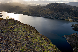
Cool breeze by joebartels   This easy hike takes you to the edge of Canyon Lake's favorite sheer wall mountain. If you've been to the lake, you've likely tilted your head, rested your index finger on your lower lip while pondering this beauty. Would you believe it's easier to attain than the half-way point on Piestewa or Camelback? It is, so head on up! This easy hike takes you to the edge of Canyon Lake's favorite sheer wall mountain. If you've been to the lake, you've likely tilted your head, rested your index finger on your lower lip while pondering this beauty. Would you believe it's easier to attain than the half-way point on Piestewa or Camelback? It is, so head on up!Canyon Lake Massif is not an official trail, so park, jump out and start scaling the wall! Old school brother! Hand over hand and don't look down. Okay, the only truth being this is not an official trail... a power-line service-road immediately spurs off to the right, heading smack dab to a saddle in the mountain. It doesn't get much easier. Head on up. The only caution would be on the incline. Beware of the somewhat loose footing.
Return by the same way. The hike is not recommended for children or dogs as there's a fair amount of cholla needles. This makes a fabulous sunset hike if you come equipped with flashlights. The sun glares off the lake in the morning to midday. I saw one faded glyph in the line of travel. Check out the Official Route and Triplogs. Leave No Trace and +Add a Triplog after your hike to support this local community. | |||||||||||||||||||||||||||||||||||||||||||||||||||||||||||||||||||||||||||||||||||||||||||||||||||||||||||||||||||||||||||||||||||||||||||||||||||||||||||||||||||||||||||||||||||||||||||||