Route Editor

| Guide | ♦ | 14 Triplogs | 1 Topic |
details | drive | permit | forecast | route |
stats |
photos | triplogs | topic | location |
| 257 | 14 | 1 |
Canyons are inherently risky. Flash floods occur without notice on sunny days. Technical skills & surrounding topography knowledge required yet does not eliminate risk.
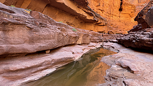
Take the House Rock for a Ride by chumley   Overview OverviewThis non-technical route descends steeply from the Marble Canyon rim to the bottom of Rider Canyon and then follows the canyon to the Colorado River at House Rock Rapids. (This hike avoids the upper portion of the canyon which is a technical route.) For hikers familiar with remote and undeveloped routes into Grand Canyon or other rough desert canyons of the southwest, this should provide a challenging but enjoyable adventure. Warning While this is a known route, it is not for the faint of heart and doesn't fit the description of a typical NPS trail, despite appearing as such on some maps. It is very steep, has poor footing on loose talus, sketchy route finding, and some exposure on bypass scrambles that border on class 4. A very steep entry/exit route drops/climbs 1000 feet in half a mile.
The trail begins at the end of the road (see driving directions below). Locate the carsonite post marked "trail" to indicate the proper starting point and begin the descent via the chute cutting through the Kaibab. You'll have to pass through two rabbit holes to avoid impassable dropoffs, the second of which is less than 2-feet in diameter and requires pack removal and a fun squeeze. At the base of the chute, the route veers down canyon rather than continuing in the drainage toward the lighter colors rock deposited from a vast rock slide caused by a significant chunk of Kaibab collapsing. (This rock slide and the lighter-colored face of collapsed Kaibab are great visual indicators to note as they help you identify where to exit on your return trip.) A series of steps and switchbacks drop you through the Coconino, with a couple of easy scrambles along the way. From here, it's just a steep and loose drop through the talus adjacent to another slide path from longer ago. When you reach the canyon bottom, take note of your surroundings and make a mental note to remember where the exit route begins. Heading down canyon, it's about 0.75 miles of mostly boulder hopping before reaching the relative highway of smooth Supai. If there's any water flowing here, I would expect that getting to the river will prove impossible as the canyon narrows and deepens. The dry slabs will eventually begin to hold small pools of water, which at this point are easily avoided. After about a mile and a half in the canyon bottom, you'll reach a pouroff in the Supai that must be bypassed. A route follows the DCR shelf for a quarter mile before dropping back down to the bottom. Again, make a note of this location as you'll need to hit this bypass on your return trip. Another half mile farther as the canyon narrows, you'll reach a large chockstone that must be bypassed about 30 feet up on the DCL via a slippery exposed route. The easiest access to this route begins about 100 yards upstream of the chockstone. The descent point won't be obvious until you reach it, with a series of short downclimb scrambles that lead to the bottom of the deep and narrow slot below the chockstone. This area is a highlight of the hike, with towering walls and shallow pools of water. Around the next corner, you reach a wall-to-wall pool at the base of a small pouroff that in most conditions is the only required wet crossing on the hike. Reports over the years indicate that this pool can be a shallow ankle-deep splash to a chilly chest-deep wade. A couple of minutes after crossing the pool, a scenic carved slide drops into another pool. Depending on conditions, you may be able to descend the slide and hop into the pool, but there's also a bypass on the DCL, again with a little bit of tricky footing and light pucker-factor before descending through a crevice alongside a large fallen boulder. From here it's just a couple of minutes to the mouth of the canyon and the roaring Colorado River as it rages through House Rock Rapids. It's easiest to wade in the sandy shallows toward the river as the banks here are thickets of salt cedar, but you may be able to keep your feet dry if you choose the forested option. You'll want to stay DCR as there is no beach area on the left once you reach the river. The beach provides excellent views both up and down canyon, and though the rapids are quite impressive, there are also calmer pockets of flow near the canyon mouth and adjacent to the downstream beach that allows safer opportunities for you to enjoy the refreshing dip the Colorado always provides. The return trip retraces your steps heading back upstream, including the three bypasses. Note that the steep exit from Rider Canyon has a westward aspect and will receive direct sun exposure all afternoon with no opportunities for shaded relief. Don't underestimate the heat on the exit climb, even in cooler weather. Water Sources Pools of water appear in the lower half mile of the canyon but appear to be heavily mineralized. I did not taste-test for salinity. Reliable drinking water can be filtered from the Colorado River unless turbid. Camping A small beach area just downstream of the confluence adjacent to House Rock Rapids would make a fine spot for camping, though there is no "established" camp here and space may be limited during higher water flow events. The trailhead above the canyon rim is on BLM land and evidence of car-camping at the trailhead exists. However, this area is notoriously windy and there's not a single tree for dozens of miles, so be prepared if you overnight up top to get an early start. Check out the Official Route and Triplogs. Leave No Trace and +Add a Triplog after your canyon trip to support this local community. | ||||||||||||||||||||||||||||||||||||||||||||||||||||||||||||||||||||||||||||||||||||||