Route Editor

| Guide | ♦ | 6 Triplogs | 0 Topics |
details | drive | no permit | forecast | route |
stats |
photos | triplogs | topics | location |
| 19 | 6 | 0 |
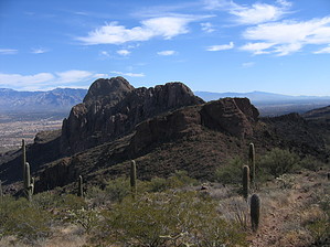
Peak Bagging Galore by fricknaley  The Northern District of the Tucson Mountains is a surprisingly wild and rugged little wilderness with some exceptional desert peak bagging and bushwacking. I hike here a lot, and today I finally put together what I call the North Tucson Mountains Superloop. It takes in mostly off-trail peak bagging of some of the prominent local landmarks and offers a rugged, relatively short adventure. The Northern District of the Tucson Mountains is a surprisingly wild and rugged little wilderness with some exceptional desert peak bagging and bushwacking. I hike here a lot, and today I finally put together what I call the North Tucson Mountains Superloop. It takes in mostly off-trail peak bagging of some of the prominent local landmarks and offers a rugged, relatively short adventure.Start this from the Sanctuary Cove, which I have fully described in my write-up of Safford Peak. This trip will start with a climb of the (locally) infamous Safford/Sombrero Peak. You can't go climbing around here without a trip up Safford. Mark your spot when you climb up the ridgeline's Southern face before making the final ascent up the western backside of Sombrero. After bagging Sombrero, head back down to the ridgeline where you can see off to both the north and south, Panther Peak is to the west.
Keep heading west and cross over a couple of wide gulleys. You want the last gulley west to start climbing up. The good news is that this is such a small area overall you can usually see where you want to go and you can't really get lost. So scramble away. At the last gulley, climb up. I crossed over to the west side and climbed up the small shelved peak to the far southwest of the formation. You can now look south at the ridgeline of Peak 3262, east at beautiful Sombrero Peak, and immediately east and slightly south at Panther Peak. These views are just brilliant. Head back down and across the nearby gulley to bag Panther Peak next. This is very close and will only take 10-20 minutes. There is no trail, but all you need to do is go up until you can't anymore. Enjoy the views from Panther. From the top of Panther, you can actually pick up a use path that seems fairly well-defined and follow it down the peak. It will eventually head east to a saddle between Panther and the Safford Ridgeline. From here, you can follow a well-cairned faint path the STEEPLY climbs down the north face of the Northern Tucson Mountains Ridgeline. Follow this out into the northern foothills desert. You can now easily see where you want to go...straight east to the small ridgeline running north and south. There are two saddles in it you can use as landmarks. I scrambled out towards an obvious fence marking the northernmost park boundary. Here you can pick up a well-defined horse trail that runs east to the destination ridgeline. Follow this quickly. It will end at the fence marking the park boundary. Cross through the gate and follow an old road until you are parallel to the more northern of the two small saddles. This is your destination. Scramble across the desert to the northern flank of the small gulley leading up to the saddle. You may pick up another well-defined horse trail on the way up. Pass through a gate at the top. From here, follow the trail south for about 10 minutes, and you will soon see Sanctuary Cove and the parking lots. There is a maze of trails here. I followed them when they seemed helpful and scrambled when I felt that more appropriate. You will end up in the Sanctuary Cove parking lot to complete your Superloop. I did not include many distances because your routes are going to be different than mine. The total trip is about 7 miles, with much up and down. A GPS, compass, or just a good knowledge of this small wilderness are needed. Have fun in my "backyard" wilderness. Please note that the accumulated elevation gain is much more than the elevation gain for climbing Safford alone (the trip highpoint), as you will bag three peaks on this trip. Gate Policy: If a gate is closed upon arrival, leave it closed after you go through. If it is open, leave it open. Leaving a closed gate open may put cattle in danger. Closing an open gate may cut them off from water. Please be respectful, leave gates as found. The exception is signage on the gate directing you otherwise.
Check out the Official Route and Triplogs. Note This is a more difficult hike. It would be unwise to attempt this without prior experience hiking. Leave No Trace and +Add a Triplog after your hike to support this local community. | |||||||||||||||||||||||||||||||||||||||||||||||||||||||||||||||||||||||||||||||||||||