username
X
password
register
for free!
help
 This is likely a great time to hike this trail!  Check out "Preferred" months below, keep in mind this is an estimate. 
  

Scotchman Peak #65, ID

Guide 5 Triplogs  0 Topics
  4.5 of 5  
Fav
Wish
1
details
drive
permit
forecast
route  
stats
photos
triplogs
topics
location
98 5 0
Statistics
tap row or icons for details
Difficulty 4 of 5
Route Finding 2 of 5
Distance One Way 3.92 miles
Trailhead Elevation 3,306 feet
Elevation Gain 3,694 feet
Accumulated Gain 3,694 feet
Avg Time One Way 4 hours
Kokopelli Seeds 16.23
 Interest Peak
feature photo
Photos Viewed All MineFollowing
13  2025-08-22 LindaAnn
15  2024-10-17 LindaAnn
15  2024-07-16 DixieFlyer
30  2023-06-26 LindaAnn
25  2022-09-12 LindaAnn
Author
author avatar Guides 110
Routes 2,246
Photos 8,982
Trips 2,600 map ( 15,998 miles )
Age 45 Female Gender
Location Ahwatukee, AZ
Associated Areas
list map done
Northern Region
Historical Weather
Trailhead Forecast
Radar Map
Expand Map
Preferred Jul, Aug, Sep, Oct → Early
Seasons   Summer to Autumn
Sun  6:07am - 7:18pm
Official Route & 5 Rts
 
0 Alternative


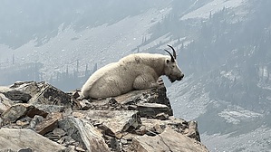
incredible views in all directions
by LindaAnn

 Likely In-Season! 
Overview: Popular trail in northern Idaho, leading to the summit of Scotchman Peak.


Hike: Starting from the trailhead, the trail is well marked and immediately begins heading uphill. Various signs warn you about grizzly bears and mountain goats in the area. This is a steep hike, with a steady gain of 3700' in just under four miles. The trail can be broken down and described in four sections.
remove free decal offer
The first 1.40 miles are constant switchbacks, about thirty of them if you are counting by corner, gaining about 1200'. The trail is easy to follow, and is in good condition, with few rocks or roots in the way. The forest is dense and green, but the views are somewhat limited due to the thick vegetation.

After the switchbacks end, the second "section" covers the next 0.90 miles, gaining another 1000'. The trail mostly goes straight up a ridge on the southern side of Scotchman. Again, the forest is fairly dense, so the views aren't the best, but you can see off the east and west sides of the ridge in places. The trail is still in good shape, easy to follow, no obstacles.

The third "section" is another series of switchbacks, long ones this time, about five total. The trees thin out quite a bit at this point, and views are excellent as you make your way up the steep slope, gaining another 950' in one mile. There are some rocks and tree roots on the trail in this section, but overall the trail is still in good shape.

The fourth "section" begins about 3.30 miles into the hike. There is another sign with the mountain goat warning, and the trail turns more to the east and becomes mostly talus. At this point, there are 0.60 miles to go with another 550' to gain. Views in all directions are incredible, and as you climb the ridge, the summit of Scotchman dramatically looms ahead to the east. The trail through the talus becomes somewhat vague in a few places, but common sense keeps you on the ridge, or slightly on the south side of the ridge, and the trail always becomes clear again after a short distance. It is a rocky final climb to the summit, but no real scrambling is required. Mountain goats frequent the summit, which has plenty of room to sit on the rocks and enjoy the views. There is also a small shelter of sorts built into the rocks at the summit, but it doesn't seem like a wind shelter, so its purpose is unclear.

Warning: Be aware of wildlife in the area, which could potentially include: mountain goats, moose, and bears (grizzly or black)

2022-09-12 LindaAnn


    Check out the Official Route and Triplogs.

    Note
    This is a moderately difficult hike.
    Leave No Trace and +Add a Triplog after your hike to support this local community.

    One-Way Notice
    This hike is listed as One-Way.

    When hiking several trails on a single "hike", log it with a generic name that describes the hike. Then link the trails traveled, check out the example.
    WARNING! Hiking and outdoor related sports can be dangerous. Be responsible and prepare for the trip. Study the area you are entering and plan accordingly. Dress for the current and unexpected weather changes. Take plenty of water. Never go alone. Make an itinerary with your plan(s), route(s), destination(s) and expected return time. Give your itinerary to trusted family and/or friends.

     Permit $$
    FS
    Backpacking camping permits: request 2 weeks in advance


     Directions
    or
     Road
    FR / Jeep Road - Car possible when dry

    To hike
    Car possible when dry, except for the last hundred feet before the trailhead.

    From Sandpoint, take ID-200 east to the small town of Clark Fork. In Clark Fork, turn left on Main St (at the Chevron station) and take Main St north. Main will curve to the east and once it reaches the intersection with Lightning Creek Rd, Main will turn into Mosquito Creek Rd. From this intersection, take Mosquito Creek Rd east for 2.1 miles to FR2294. There is a sign for #65 at this intersection, but nothing indicating the forest road number. Turn right onto FR2294 and follow it for 1 mile. At this fork, turn left to stay on FR2294. There is a small brown sign #65, easy to miss. Stay on FR2294 for another .5 mile, then turn left onto FR2294A. Again, there is a small post with a #65, but hard to see. Follow FR2294 to the end, where there is a parking area and restrooms for the trailhead. Lower clearance vehicles will want to park just before the restrooms.

    Mileage from the Chevron station to the trailhead is 6.30 miles.
    page created by HAZ_Hikebot on Sep 12 2022 4:03 pm
     90+° 8am - 6pm kills
    helpcorrectionissue

    end of page marker