Route Editor

| Guide | ♦ | 40 Triplogs | 3 Topics |
details | drive | permit | forecast | 🔥 route |
stats |
photos | triplogs | topics | location |
| 455 | 40 | 3 |
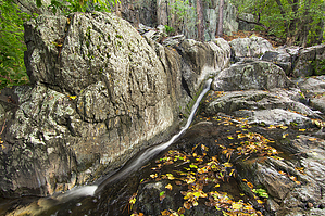
Heard it through the HAZ Forum by joebartels  2020 Note 2020 NotePrescott NF has apparently decommissioned this trail. Likely due to Grapevine Road crossing the Butternut Mine property. You may hike the unmaintained trail, access from the lower end at your own risk. Hike Grapevine Canyon is a Prescott National Forest Botanical Protected Area. It lies on the eastern flank of lava-capped Big Bug Mesa on the edge of the Bradshaw Mountains. This mostly pleasant out-n-back hike takes you up to Grapevine Springs. On this trip, there was still some light snow cover on the south canyon slopes. The creek was flowing at maybe one gallon per second. Which is just enough to keep things interesting.
The lower canyon has a few patches of uncommonly large stands of Alders. A few small cascades keep the creek gurgling throughout the hike. I noted several animal tracks through the snow/mud and to my delight, not one human footprint. Around 1.1 miles in the trail abruptly leaves the peaceful creek setting to bona fide Arizona blood-sucking chaparral. The trail is well cut but even in February, you feel the sun pounding down. After a short steep climb, the trail levels out and soon enters an oak forest. Soon you pass through a research experimental plot. Here you are asked to respect the area and not disturb anything. (I guess outside the fenced area, it's fair game to raise hell.) Past the research plot the trail crosses the creek to the left, then high banks it over to the springs. The ground is very soft in places, especially around the multiple springs lining the left slope. Try and stay on the hand-laid-rock trail. The topographical map plots several springs in the area. On location it looks like the side of the mountain is gently dispersing water from a large swath. The trail continues(apparently connects to FR103A). I'd seen enough and headed back. I'm unsure if the springs flow year-round. There are remnants of at least 4-inch diameter pipe that must have funneled water 30-40 years ago. Most pipes I've seen in other parts of Arizona are in the 1-inch diameter category. Check out the Official Route and Triplogs. Leave No Trace and +Add a Triplog after your hike to support this local community. | |||||||||||||||||||||||||||||||||||||||||||||||||||||||||||||||||||||||||||||||||||||||||||||||||||||||||||||||||||||||||||||||||||||||||||||||||||||||||||||||||||||||||||||||||||||||||||||||||||