Route Editor

| Guide | ♦ | 73 Triplogs | 2 Topics |
details | drive | no permit | forecast | 🔥 route |
stats |
photos | triplogs | topics | location |
| 799 | 73 | 2 |
Canyons are inherently risky. Flash floods occur without notice on sunny days. Technical skills & surrounding topography knowledge required yet does not eliminate risk.
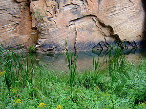
Beautiful intro to canyoneering by bmaaske  This is a beautiful canyon to explore for those that are a little adventurous and not afraid to get more than a little wet. I've wanted to try some canyoneering but wasn't committed to something needing ropes or swim fins. This hike exactly fits the bill. You can decide how far up the canyon you want to go and can do this as an out-and-back, or even a one-way if you drop a car at the Maxwell or Tramway trailheads to the northeast. We hiked from Point trailhead to the petroglyph wall local, right between Maxwell Trail #37 and Tramway Trail #32. We dawdled a lot and explored a lot. It took us exactly 6 hours start-to-finish. This is a beautiful canyon to explore for those that are a little adventurous and not afraid to get more than a little wet. I've wanted to try some canyoneering but wasn't committed to something needing ropes or swim fins. This hike exactly fits the bill. You can decide how far up the canyon you want to go and can do this as an out-and-back, or even a one-way if you drop a car at the Maxwell or Tramway trailheads to the northeast. We hiked from Point trailhead to the petroglyph wall local, right between Maxwell Trail #37 and Tramway Trail #32. We dawdled a lot and explored a lot. It took us exactly 6 hours start-to-finish.West Clear Creek is located on top of the Mogollon Rim. The east end of West Clear Creek is a 700ft deep sandstone walled canyon with nearly vertical walls throughout. This is one of the few trailheads allowing access to this area from the south side. A few miles further up the canyon to the east are the more popular Maxwell and Tramway trailheads accessible from the north rim of this canyon.
Hike: Starting at the trailhead at N34 32.747 W111 26.018, you immediately drop down into the canyon on a rather steep trail. There is no actual climbing involved, but you will need your hands in many places. The trail down enters the canyon bottom at N34 32.873 W111 26.201. We went entirely up the canyon, but just a little way down canyon from where the trail enters the canyon is a cool weeping wall worth checking out if you have time. From the trail's entry point, proceed up the canyon to the east. You will almost immediately need to get wet. There may be ways to scamper up a canyon wall in some places and avoid getting wet, but it is impossible to avoid in several areas. You might as well embrace it. Additionally, it is probably safer to wade through the water in many places than climb around on cliffs. As you proceed up the canyon, you will find a cool side canyon to your left about 0.3 miles from the start at the bottom of the canyon. It's worth exploring and doesn't go back too far. Another 0.5 miles or so, you will pass a spring flowing into the canyon from the south wall. It has a good flow and appears to be coming straight out of the ground. About 2 miles further up the canyon on the north wall, you will pass another side canyon. Immediately after this, on the main canyon wall, there are a bunch of interesting petroglyphs. Some of these are obviously fake, but the majority of them are the real deal. The glyphs are at N34 33.367 W111 24.972. The Maxwell trail meets the canyon bottom about another 0.5 miles up from the glyphs. I understand that you can continue up this canyon for several more miles. We ended our hike at this point and turned around, and went back the way we came. The ascent back up the canyon again was steep and challenging. You will want your hands free to hang on and assist in climbing over large rocks, trees, and ledges. I think this canyon is every bit as beautiful as the West Fork of Oak Creek. It has diverse flora, vines everywhere, cattails, maple, oak, pine, fir, etc. It doesn't get much greener than this in Arizona. I've been told that there is a lot of poison ivy in this area. While I saw things that possibly could be poison ivy, none of us got into any. Check out the Official Route and Triplogs. Leave No Trace and +Add a Triplog after your canyon trip to support this local community. | |||||||||||||||||||||||||||||||||||||||||||||||||||||||||||||||||||||||||||||||||||||||||||||||||||||||||||||||||||||||||||||||||||||||||||||||||||||||||||||||||||||||||||||||||||||||||||||||||||||||||||||