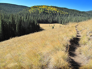
The trail starts just out of the parking area and through the gate. Please take a moment to sign the visitor register. The trail is easy to follow as it cuts across a wide meadow and edges up to the West Fork of Little Colorado River. The trail follows the stream for the next two miles, climbing gradually. This stretch is the most heavily used portion of the trail and quite possibly the most heavily used trail on the Forest. If you have a problem with lots of other hikers, avoid this trail on weekends and holidays. As the trail begins a more noticeable climb, the crowds thin out. The trail crosses the West Fork over an old bridge and continues its uphill grade. The ascent is no vein-popper, but it can be taxing due to the steady climb and high elevation.
The trail crosses meadows and winds through a thick forest setting dominated by spruce, fir, and aspen. Beaver dams dot the streams, and fishing on the West Fork is generally good. As you work your way up, the trail becomes a series of switchbacks. Please stay on the trail and resist the temptation to shortcut. This damages the soil, scars the land and causes erosion. All of which could wash out the established trail and bring silt into the creek. The West Baldy Trail merges with the East Baldy Trail in a saddle near the Reservation boundary below Mt. Thomas. At this point, you can see some new country and continue down to the other side, or turn around and see the trail you just came up from a different angle. Each trail is a 7-mile hike from this point. Many hikers park a vehicle at the Sheeps Crossing trailhead and another at the Phelps trailhead as shuttle vehicles. The summit of Mt. Baldy is on the White Mountain Apache Reservation and is closed to all non-tribal members. Please respect their customs and laws and do not travel to the top.
remove free decal offer
Note
Group size limits are 12 for hiking and riding and 6 for camping.
Gate Policy: If a gate is closed upon arrival, leave it closed after you go through. If it is open, leave it open. Leaving a closed gate open may put cattle in danger. Closing an open gate may cut them off from water. Please be respectful, leave gates as found. The exception is signage on the gate directing you otherwise.
Lightning Kills
Stay off the mountain when thunderstorms are forecasted. July and August are notorious for quick unexpected storms. Lower the risk by being OFF the mountain before 11am on a clear morning. Stay safe, read the NOLS Backcountry Lightning Safety Guidelines.
When hiking several trails on a single "hike", log it with a generic name that describes the hike. Then link the trails traveled, check out the example.
WARNING! Hiking and outdoor related sports can be dangerous. Be responsible and prepare for the trip. Study the area you are entering and plan accordingly. Dress for the current and unexpected weather changes. Take plenty of water. Never go alone. Make an itinerary with your plan(s), route(s), destination(s) and expected return time. Give your itinerary to trusted family and/or friends.
 Route Editor


