 Route Editor

Mount Tritle, AZ :: Trail down north slope?
Moderator: HAZ - Moderators
Linked Area, etc none
-
 inderockerGuides: 0 | Official Routes: 0Triplogs Last: none | RS: 0Water Reports 1Y: 0 | Last: never
 - Joined: Feb 11 2008 2:59 am
- City, State: Prescott Valley, Z
Mount Tritle, AZ :: Trail down north slope?
Did this hike today and noticed at the top of Tritle, there was another trail the went down the north slope. It was very steep and looked to have been mainly used by dirt bikes, but not used in quite some time. We took it for a mile or so then took another rarely used trail that bee-lined it to FR79. Any idea where this trail ends up?
contribute to this member driven resource
ie: RS > Save/Share after hikes 

-
 ASUAviatorGuides: 1 | Official Routes: 2Triplogs Last: 3,271 d | RS: 0Water Reports 1Y: 0 | Last: 3,334 d
 - Joined: Nov 06 2010 12:12 pm
- City, State: Phoenix, AZ
Re: Mount Tritle, AZ :: Question by inderocker
Sounds like you answered your own question... Theres mines everywhere in that area and multiple trails that essentially get you the same place. Sounds like it would have eventually met up with the trails at the bottom. Its doesn't sound like youre talking about the trail that follows the ridgeline down and comes out at lower wolf creek ??inderocker wrote:We took it for a mile or so then took another rarely used trail that bee-lined it to FR79
contribute to this member driven resource
ie: RS > Save/Share after hikes
-
 kingsnakeGuides: 122 | Official Routes: 119Triplogs Last: 7 d | RS: 0Water Reports 1Y: 2 | Last: 125 d
 - Joined: Dec 20 2010 7:14 am
- City, State: Sunnyslope, PHX
- RUMBLE: Kingsnake1986
- VIMEO: kingsnakesince1986
- Contact:
Re: Mount Tritle, AZ :: Question by inderocker
Was up there two days ago (day before you) with prescottstyle. He told me that is the "Senator Hwy Trail". Not sure if it has a name, or that name, but that is where it ends up.
http://prestonm.com : Everyone's enjoyment of the outdoors is different and should be equally honored.
contribute to this member driven resource
ie: RS > Save/Share after hikes
-
kingsnakeGuides: 122 | Official Routes: 119Triplogs Last: 7 d | RS: 0Water Reports 1Y: 2 | Last: 125 d
- Joined: Dec 20 2010 7:14 am
- City, State: Sunnyslope, PHX
- RUMBLE: Kingsnake1986
- VIMEO: kingsnakesince1986
- Contact:
Re: Mount Tritle, AZ :: Question by inderocker
Btw, did you find the summit log? We couldn't ... 
http://prestonm.com : Everyone's enjoyment of the outdoors is different and should be equally honored.
contribute to this member driven resource
ie: RS > Save/Share after hikes
-
inderockerGuides: 0 | Official Routes: 0Triplogs Last: none | RS: 0Water Reports 1Y: 0 | Last: never
- Joined: Feb 11 2008 2:59 am
- City, State: Prescott Valley, Z
Re: Mount Tritle, AZ :: Question by inderocker
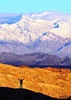
Nope, no summit log. The trail headed off in the direction of the Senator mine, but the spur we took off of that spit us out onto FR79 about a mile or so south of the gate. I was hoping to find the head of this trail and take it up to Tritle next time I'm out there. There was also a little memorial for "Richard Lee Maier" not far from the top of Tritle.
- Attachments
-
-
contribute to this member driven resource
ie: RS > Save/Share after hikes
-
kingsnakeGuides: 122 | Official Routes: 119Triplogs Last: 7 d | RS: 0Water Reports 1Y: 2 | Last: 125 d
- Joined: Dec 20 2010 7:14 am
- City, State: Sunnyslope, PHX
- RUMBLE: Kingsnake1986
- VIMEO: kingsnakesince1986
- Contact:
Re: Mount Tritle, AZ :: Trail down north slope?
Oh man, that is a sweet find. I definitely need to go back. (Photographing memorials is one of my hobbies.) Where was that located in relation to the mountain top cairns?
http://prestonm.com : Everyone's enjoyment of the outdoors is different and should be equally honored.
contribute to this member driven resource
ie: RS > Save/Share after hikes
-
inderockerGuides: 0 | Official Routes: 0Triplogs Last: none | RS: 0Water Reports 1Y: 0 | Last: never
- Joined: Feb 11 2008 2:59 am
- City, State: Prescott Valley, Z
Re: Mount Tritle, AZ :: Trail down north slope?
From the Summit of Tritle, there's a seldom used trail going down the north slope (the trail in question). The memorial was about a 1/2 mile from the summit.
contribute to this member driven resource
ie: RS > Save/Share after hikes
-
 hikeazGuides: 6 | Official Routes: 0Triplogs Last: 1,245 d | RS: 0Water Reports 1Y: 0 | Last: 1,245 d
 - Joined: May 13 2002 10:07 am
- City, State: Tempe, AZ
- Contact:
Re: Mount Tritle, AZ :: Trail down north slope?
It appears that what is now a trail of sorts was formerly a road, as shown on the CT 1900 & CT 1930 maps.
"The censorship method ... is that of handing the job over to some frail and erring mortal man, and making him omnipotent on the assumption that his official status will make him infallible and omniscient."
George Bernard Shaw
George Bernard Shaw
contribute to this member driven resource
ie: RS > Save/Share after hikes