 Route Editor

Burning near Woodbury Trailhead. It has grown to 500 acres. I'll post official links as soon as they're up.
The smoke plume does not look good.
Inciweb
Updated 2019-07-16 123,875 Acres - 100% Contained
[ Woodbury Fire Perimeter :: map ]
Woodbury Fire - Superstition Wilderness
Moderator: HAZ - Moderators
Linked Guides none
-
 chumleyGuides: 94 | Official Routes: 239Triplogs Last: 4 d | RS: 73Water Reports 1Y: 95 | Last: 3 d
 - Joined: Sep 18 2002 8:59 am
- City, State: Tempe, AZ
contribute to this member driven resource
ie: RS > Save/Share after hikes 

-
 skatchkinsGuides: 2 | Official Routes: 6Triplogs Last: 628 d | RS: 1Water Reports 1Y: 0 | Last: 2,894 d
 - Joined: Dec 22 2007 8:08 pm
- City, State: Mesa, AZ
- Contact:
Re: Woodbury Fire - Superstition Wilderness
I see civil conversations, learning, and spin-off threads. I enjoy all this discussion activity.
May he guide you through the wilderness : protect you through the storm;
May he bring you home rejoicing : at the wonders he has shown you;
Armchair Crisis Design
May he bring you home rejoicing : at the wonders he has shown you;
Armchair Crisis Design
contribute to this member driven resource
ie: RS > Save/Share after hikes
-
 nonotGuides: 107 | Official Routes: 108Triplogs Last: 109 d | RS: 0Water Reports 1Y: 9 | Last: 109 d
 - Joined: Nov 18 2005 11:52 pm
- City, State: Phoenix, AZ
Re: Woodbury Fire - Superstition Wilderness
Maybe if we talked about the weather instead?
http://hikearizona.com/garmin_maps.php
Hike Arizona it is full of sharp, pointy, ankle-twisting, HAZmaster crushing ROCKS!!
Hike Arizona it is full of sharp, pointy, shin-stabbing, skin-shredding plants!
Hike Arizona it is full of striking, biting, stabbing, venomous wildlife!
Hike Arizona it is full of sharp, pointy, ankle-twisting, HAZmaster crushing ROCKS!!
Hike Arizona it is full of sharp, pointy, shin-stabbing, skin-shredding plants!
Hike Arizona it is full of striking, biting, stabbing, venomous wildlife!
contribute to this member driven resource
ie: RS > Save/Share after hikes
-
chumleyGuides: 94 | Official Routes: 239Triplogs Last: 4 d | RS: 73Water Reports 1Y: 95 | Last: 3 d
- Joined: Sep 18 2002 8:59 am
- City, State: Tempe, AZ
Re: Woodbury Fire - Superstition Wilderness
I'm not sure what my spirit animal is, but I'm confident it has rabies.
contribute to this member driven resource
ie: RS > Save/Share after hikes
-
 pixelfrogGuides: 0 | Official Routes: 0Triplogs Last: 2,195 d | RS: 0Water Reports 1Y: 0 | Last: never
 - Joined: Apr 11 2002 10:00 am
- City, State: Chandler, AZ
- Contact:
contribute to this member driven resource
ie: RS > Save/Share after hikes
-
pixelfrogGuides: 0 | Official Routes: 0Triplogs Last: 2,195 d | RS: 0Water Reports 1Y: 0 | Last: never
- Joined: Apr 11 2002 10:00 am
- City, State: Chandler, AZ
- Contact:
Re: Woodbury Fire - Superstition Wilderness
Reavis Mountain School and Campaign Creek post fire. Not horrible, maybe some of the larger trees and riparian areas survived. I'm still worried about all the springs in the burn area though.

contribute to this member driven resource
ie: RS > Save/Share after hikes
-
 AKGuides: 0 | Official Routes: 0Triplogs Last: 7,620 d | RS: 0Water Reports 1Y: 0 | Last: never
 - Joined: Mar 06 2003 2:49 am
- City, State: Mesa, AZ
Re: Woodbury Fire - Superstition Wilderness
@Jim_H
You know that it is ok to skip over a topic if it doesn't suit you and just go on with your life.
You know that it is ok to skip over a topic if it doesn't suit you and just go on with your life.
Aaron
"Can't think of a good signature quote" - Me
"Can't think of a good signature quote" - Me
contribute to this member driven resource
ie: RS > Save/Share after hikes
-
 kelly14Guides: 0 | Official Routes: 0Triplogs Last: 1,799 d | RS: 50Water Reports 1Y: 0 | Last: 1,799 d
 - Joined: Sep 27 2015 5:26 pm
- City, State: Phoenix
Re: Woodbury Fire - Superstition Wilderness
https://inciweb.nwcg.gov/incident/article/6405/49525/
Thought this was cool.
It basically says that the Woodbury fire burned 538 acres at a high severity, 29,452 moderate burn, 65,735 low intensity burn, and 28,149 very low to unburned
Thought this was cool.
It basically says that the Woodbury fire burned 538 acres at a high severity, 29,452 moderate burn, 65,735 low intensity burn, and 28,149 very low to unburned
Last edited by kelly14 on Jul 07 2019 4:49 pm, edited 1 time in total.
contribute to this member driven resource
ie: RS > Save/Share after hikes
-
 cw50mustGuides: 11 | Official Routes: 1Triplogs Last: 479 d | RS: 0Water Reports 1Y: 0 | Last: 3,370 d
 - Joined: Jun 09 2009 8:10 am
- City, State: Mesa, AZ
Re: Woodbury Fire - Superstition Wilderness
I noticed that the Reeves Mountain School has updated their website that shows some pictures from the burned areas around them.
https://www.reevismountain.org/about-the-fire
https://www.reevismountain.org/about-the-fire
contribute to this member driven resource
ie: RS > Save/Share after hikes
-
 whereveriroamGuides: 8 | Official Routes: 0Triplogs Last: 907 d | RS: 0Water Reports 1Y: 0 | Last: 914 d
 - Joined: Mar 07 2003 3:14 pm
- City, State: Apache Junction, AZ
Re: Woodbury Fire - Superstition Wilderness
Although the fire is not out, this fire was called 100% contained today. The BAER soil burn severity map was issued last week but I bet most of the unburned area’s on that map have burned since. Looks like they saved the area south of W. Pinto Creek and east of Sawtooth Ridge to Miles Ranch and the 287A? road. I bet the Rock Creek trail will become popular.
Last edited by whereveriroam on Jul 16 2019 5:41 pm, edited 1 time in total.
contribute to this member driven resource
ie: RS > Save/Share after hikes
-
AKGuides: 0 | Official Routes: 0Triplogs Last: 7,620 d | RS: 0Water Reports 1Y: 0 | Last: never
- Joined: Mar 06 2003 2:49 am
- City, State: Mesa, AZ
Re: Woodbury Fire - Superstition Wilderness
Reavis Ranch.........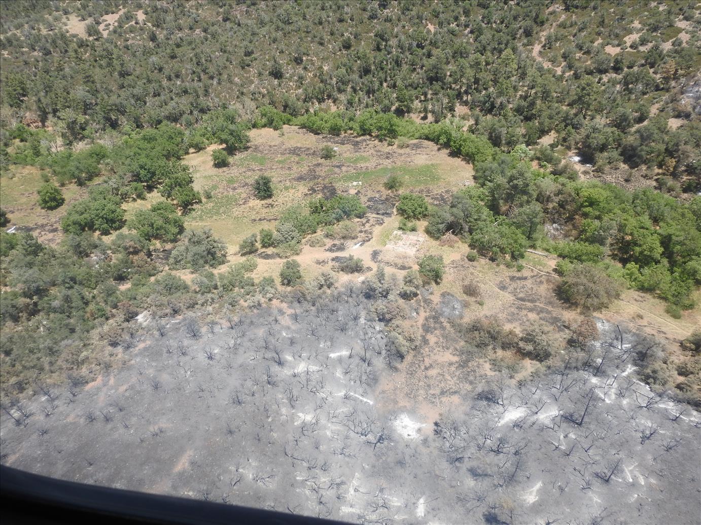 . Looks like the house foundation in the middle of the pic.
For more pics.....http://www.arcgis.com/home/webmap/viewe ... 0VxXBDD0VU
. Looks like the house foundation in the middle of the pic.For more pics.....http://www.arcgis.com/home/webmap/viewe ... 0VxXBDD0VU
Last edited by AK on Jul 17 2019 4:45 pm, edited 3 times in total.
Aaron
"Can't think of a good signature quote" - Me
"Can't think of a good signature quote" - Me
contribute to this member driven resource
ie: RS > Save/Share after hikes
-
 JimGuides: 76 | Official Routes: 39Triplogs Last: 32 d | RS: 93Water Reports 1Y: 6 | Last: 44 d
 - Joined: Sep 08 2006 8:14 pm
Re: Woodbury Fire - Superstition Wilderness
Whatever that was, it has green grass growing in the middle of it.
But I never saw it before the fire.
But I never saw it before the fire.
contribute to this member driven resource
ie: RS > Save/Share after hikes
-
 SuperstitionGuyGuides: 0 | Official Routes: 0Triplogs Last: 1,824 d | RS: 0Water Reports 1Y: 0 | Last: never
 - Joined: Dec 25 2005 8:24 pm
- City, State: Queen Creek, Arizona
Re: Woodbury Fire - Superstition Wilderness
Is SR 88 or Apache Trail still closed. IE - can I drive from the dam to Apache Junction upon my return to Arizona....
A man's body may grow old, but inside his spirit can still be as young and restless as ever.
- Garth McCann from the movie Second Hand Lions
Another victim of Pixel Trivia.
Current avatar courtesy of Snakemarks
- Garth McCann from the movie Second Hand Lions
Another victim of Pixel Trivia.
Current avatar courtesy of Snakemarks
contribute to this member driven resource
ie: RS > Save/Share after hikes
-
 joebartelsGuides: 264 | Official Routes: 224Triplogs Last: 2 d | RS: 2064Water Reports 1Y: 28 | Last: 12 d
 - Joined: Nov 20 1996 12:00 pm
Re: Woodbury Fire - Superstition Wilderness
@SuperstitionGuy
still shows closed @ https://az511.gov/
but it's been almost a month since they updated
might call 511 too
routing with google shows it is still closed
the red circle w/minus says closed hovering over the icon
still shows closed @ https://az511.gov/
but it's been almost a month since they updated
might call 511 too
- joe
contribute to this member driven resource
ie: RS > Save/Share after hikes
-
chumleyGuides: 94 | Official Routes: 239Triplogs Last: 4 d | RS: 73Water Reports 1Y: 95 | Last: 3 d
- Joined: Sep 18 2002 8:59 am
- City, State: Tempe, AZ
Re: Woodbury Fire - Superstition Wilderness
@SuperstitionGuy The site for official information about this fire explains the highway closure and where to find information about it and many other questions.
It is also linked to the first post in this thread.
https://inciweb.nwcg.gov/incident/6382/
It is also linked to the first post in this thread.
https://inciweb.nwcg.gov/incident/6382/
I'm not sure what my spirit animal is, but I'm confident it has rabies.
contribute to this member driven resource
ie: RS > Save/Share after hikes
-
nonotGuides: 107 | Official Routes: 108Triplogs Last: 109 d | RS: 0Water Reports 1Y: 9 | Last: 109 d
- Joined: Nov 18 2005 11:52 pm
- City, State: Phoenix, AZ
Re: Woodbury Fire - Superstition Wilderness
closed at tortilla flat. Nice pic of the ranch, but that looks like a mighty suspicious fire pattern
i'd be willing to be the ranch/orchard had some help surviving that fire.
i'd be willing to be the ranch/orchard had some help surviving that fire.
http://hikearizona.com/garmin_maps.php
Hike Arizona it is full of sharp, pointy, ankle-twisting, HAZmaster crushing ROCKS!!
Hike Arizona it is full of sharp, pointy, shin-stabbing, skin-shredding plants!
Hike Arizona it is full of striking, biting, stabbing, venomous wildlife!
Hike Arizona it is full of sharp, pointy, ankle-twisting, HAZmaster crushing ROCKS!!
Hike Arizona it is full of sharp, pointy, shin-stabbing, skin-shredding plants!
Hike Arizona it is full of striking, biting, stabbing, venomous wildlife!
contribute to this member driven resource
ie: RS > Save/Share after hikes
-
 big_loadGuides: 0 | Official Routes: 1Triplogs Last: 508 d | RS: 3Water Reports 1Y: 0 | Last: 2,711 d
 - Joined: Oct 28 2003 11:20 am
- City, State: Andover, NJ
Re: Woodbury Fire - Superstition Wilderness
One of the official posts mentioned protecting a few places of historical interest.nonot wrote:i'd be willing to be the ranch/orchard had some help surviving that fire.
contribute to this member driven resource
ie: RS > Save/Share after hikes
-
 SredfieldGuides: 4 | Official Routes: 4Triplogs Last: 102 d | RS: 0Water Reports 1Y: 0 | Last: 731 d
 - Joined: Sep 08 2002 1:07 pm
- City, State: Ahwatukee, AZ
Re: Woodbury Fire - Superstition Wilderness
I remember some reports that they had crews on the ground backfiring from the ranch.
Shawn
The bear went over the mountain to see what he could see.
The bear went over the mountain to see what he could see.
contribute to this member driven resource
ie: RS > Save/Share after hikes
-
 wildwesthikesGuides: 0 | Official Routes: 0Triplogs Last: 2,080 d | RS: 0Water Reports 1Y: 0 | Last: 1,937 d
 - Joined: Nov 23 2010 9:41 am
Re: Woodbury Fire - Superstition Wilderness
If you drive up AZ 87 toward Payson you'll see the closure warnings for SR 88 at Hwy 188. My guess it will be the end of August before the closures lift.
I have been a bit chagrined at the lack of website updates from the FS. For example - same trip up north to Payson last Friday the Coconino Forest Website said "No current restrictions" in big letters. Same day, as I get close to Payson there were signs everywhere saying No Campfires, no charcoal grills. Makes me wonder if we will get timely notice of the Superstitions opening back up or if someone will just randomly call the FS office to get that info.
I have been a bit chagrined at the lack of website updates from the FS. For example - same trip up north to Payson last Friday the Coconino Forest Website said "No current restrictions" in big letters. Same day, as I get close to Payson there were signs everywhere saying No Campfires, no charcoal grills. Makes me wonder if we will get timely notice of the Superstitions opening back up or if someone will just randomly call the FS office to get that info.
Last edited by wildwesthikes on Jul 18 2019 8:14 am, edited 4 times in total.
contribute to this member driven resource
ie: RS > Save/Share after hikes
-
chumleyGuides: 94 | Official Routes: 239Triplogs Last: 4 d | RS: 73Water Reports 1Y: 95 | Last: 3 d
- Joined: Sep 18 2002 8:59 am
- City, State: Tempe, AZ
Re: Woodbury Fire - Superstition Wilderness
This is a common occurrence and you wouldn't be the first to be confused by it. Very few of the many people who camp on the rim in summer recognize the boundaries between the various national forests and districts. It's something that I wish the forests would get together and do a better job at communicating.elleryjk wrote:trip up north to Payson last Friday the Coconino Forest Website said "No current restrictions" in big letters. Same day, as I get close to Payson there were signs everywhere saying No Campfires, no charcoal grills
Everything you saw was true. There are no current restrictions on the Coconino Forest. But to get there you have to drive through Payson, which is surrounded by the Tonto Forest, which DOES currently have restrictions. It makes sense that the residents and government of Payson wishes to inform the traveling public of the restrictions that covers all the land below the rim. But a large percentage of people are just passing through, and it's confusing when it's not specified that there are no restrictions just a few miles beyond the signs that flash "no fires".
I'm not sure what my spirit animal is, but I'm confident it has rabies.
contribute to this member driven resource
ie: RS > Save/Share after hikes
-
wildwesthikesGuides: 0 | Official Routes: 0Triplogs Last: 2,080 d | RS: 0Water Reports 1Y: 0 | Last: 1,937 d
- Joined: Nov 23 2010 9:41 am
Re: Woodbury Fire - Superstition Wilderness
@chumley
That makes more sense. I had a suspicion that was what was going on - thanks for the detailed explanation!
That makes more sense. I had a suspicion that was what was going on - thanks for the detailed explanation!
contribute to this member driven resource
ie: RS > Save/Share after hikes