Wikipedia wrote:The Apache Trail in Arizona was a stagecoach trail that ran through the Superstition Mountains. It was named the Apache Trail after the Apache Indians who originally used this trail to move through the Superstition Mountains.
The current Apache Trail links Apache Junction (33.4152°N 111.5807°W) at the edge of the Greater Phoenix area with Theodore Roosevelt Lake (33.6725°N 111.1531°W), through the Superstition Mountains and the Tonto National Forest.
Today, the majority of Apache Trail remains unpaved, turning into a dirt road a few miles up from Tortilla Flat, and continuing as such for nearly the full remainder of its length. The section east of Apache Junction is known officially as State Route 88. It is also the main traffic corridor through Apache Junction, turning into Main Street as the road passes into Mesa, and regains the Apache name by becoming Apache Boulevard in Tempe, ending at Mill Avenue. Prior to the completion of the Superstition Freeway in 1992, the Apache Junction portion of the Apache Trail was part of US Highway 60, which was rerouted to the Superstition Freeway once it was completed.
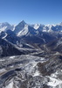
The Trail winds steeply through 40 miles (64 km) of rugged desert mountains, past deep reservoir lakes like Canyon Lake and Apache Lake. The narrow, winding road is unpaved from just east of the town of Tortilla Flat to Roosevelt Dam; there are steep cliff drops and little in the way of safety barriers. The trail requires caution when driving and it is not recommended for large RVs, SUVs, or caravans. Some large RV rental companies in the US do not allow their vehicles to be taken on this route.
The Apache Trail will be closed for some major road repairs from November 15 - January 21, 2011. major delays will occur prior to and after those stated dates. Plan your outings accordingly.
The feds are repairing the Apache Trail! (no @superstitionguy, not that section)
The Federal Highway Administration... is proposing improvements to a 11.16-mile, gravel section of the Apache Trail (Arizona State Route [SR] 88) between milepost (MP) 229.2 near the Apache Lake Marina and MP 240.6 near the Theodore Roosevelt Dam. The proposed improvements include applying an aggregate base and a chip seal pavement to an 11.16-mile section of the roadway.
Pavement. Pfancy!
I'm not sure what my spirit animal is, but I'm confident it has rabies.
I see that someone made a comment here a while ago that it was open from the East to the northern Reavis trailhead but when I go to the 511 site, it makes it look like it's closed a bit farther East than that. Can anyone confirm that they've seen if it's actually open to the point you could get to the TH?
I believe I've seen several instances that refute the post you are referring to. Plus ADOT (az511) still shows the closure just after the marina (still well short of Reavis North access).
Hike Arizona it is full of sharp, pointy, ankle-twisting, HAZmaster crushing ROCKS!!
Hike Arizona it is full of sharp, pointy, shin-stabbing, skin-shredding plants!
Hike Arizona it is full of striking, biting, stabbing, venomous wildlife!
@joebartels
Yeh, I saw that, too, but it's a bit of a drive for me so I'd prefer something more than, "a friend told me something" Now that things are cooling off a bit, trying to plan on some nice eastern supe backpacking trips as I haven't explored out there... Not sure if my subaru can make the rogers trough TH so trying to plan alternative starting points.
Also, what passenger vehicles are only 60" wide anyway...? Neither my SUV or my mid-size car are and I just googled a some other models and I'm not finding anything. Makes me question that as well
@wallyfrack
Not the preference but a nice option to have if I were to go there and find something closed. I haven't been out there before; when you did this, was there somewhere you could leave your car for a few days?
edit: nevermind. pulled it up on google maps and looks like there is a parking area and you can probably follow most of a wash to the trailhead. Thanks for the heads up!
@chumley
Thanks, very much appreciate the reply and checking on that. Kind of disappointing, though; just another restriction making that side of the supes harder to access which is a bummer.
So there's someone on the Supes FB page saying 88 was closed at Tortilla Flats until a few days ago. He stated it's been closed since December of last year? Anyone else heard this? He posted some snipit from some random Forest Service page or something. He's adamant it was closed from Tortilla Flats and not FCH. First I and 100's if not 1000's of others heard of it.
For about 4-6 months after the rockslide it was closed at tortilla flats. Then the closure was changed to the top of FCH as the rest of the way to the top of Fish Creek Hill was cleared and reopened (I don't really think much clearing was needed.) It has been closed at the top of FCH for perhaps 1.5 years now (?)
Hike Arizona it is full of sharp, pointy, ankle-twisting, HAZmaster crushing ROCKS!!
Hike Arizona it is full of sharp, pointy, shin-stabbing, skin-shredding plants!
Hike Arizona it is full of striking, biting, stabbing, venomous wildlife!
DixieFlyer
True story. The amount of people who go to facebook to ask things like "is there a fire ban?" vs doing a quick google search (admittedly, the FS sites suck but it's not hard) show that you can't rely on people there (unless you're looking for medical advise, then obbbbbbbbbviously facebook makes sense)
Yes it is open all the way to the lookout/parking area/cell towers at the top of Fish Creek Hill. It still is a beautiful drive and gets some snowbird traffic but not as much as it did in years past. There is numerous side roads for access to adventure but you need a something better than a standard car. You will see some fire damage but it is growing back where the fire reached the road.
A man's body may grow old, but inside his spirit can still be as young and restless as ever.
- Garth McCann from the movie Second Hand Lions
@big_load
I tried but he's not backing down but yet couldn't link anything to provide truth to what he was saying. I'm up there a couple times just about every week and I've never heard about this closure. I scoured the Forest Service page and it's archives to no avail. But he's still telling me I'm wrong. Sometimes you just can't fix stupid I guess.
 Route Editor