 Route Editor

I am planning a trip to the Salome Jug this June. I have a few questions to help me prepare since this appears to be a dangerous hike.
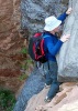
I am taking rappelling lessons now since there is a 25' rappel. My instructor asked me to learn more about the anchor system so he can get me ready. Is there only one anchor or two? Where is the anchor located in relation to where the water goes over the falls? Is it right where the water goes over the edge or is it on a wall a few feet above the falls?
One post said there is a 100 yard swim below the falls. Is that correct? Is the entire length of the swim in deep water?
Lastly, can you describe how to get from the trail down into the jug. Do you walk upstream a ways and then work your way downstream into the "Jug"?
Any help would be appreciated.
Austinboston
Salome Jug
Moderator: HAZ - Moderators
Linked Area, etc none
-
 austinbostonGuides: 0 | Official Routes: 0Triplogs Last: none | RS: 0Water Reports 1Y: 0 | Last: never
 - Joined: May 04 2002 6:48 pm
- City, State: Leesburg, Virginia
contribute to this member driven resource
ie: RS > Save/Share after hikes 

-
 azrocksGuides: 0 | Official Routes: 0Triplogs Last: none | RS: 0Water Reports 1Y: 0 | Last: never
 - Joined: Mar 21 2002 5:38 pm
It's hard to miss the drop-in, there is a good trail that takes you to the creek in about 2 miles, then you go with the flow. There is a 20 ft falls that looks scary but is like a waterpark slide, you'll make several trips down this one, then two down climbs of around 10 feet that are tricky when there's a lot of water as you can't see the handholds, and the rock is slippery. There is a new two-bolt anchor right at the top of the main fall, and if you use this one, the rap is longer than 25 ft, as you are stemming down the fall at 45 degrees. The older anchor is two bolts, accessed by walking 30 ft along a slippery ledge and from this anchor you can rap vertically into the base of the falls. The pool at the end of the rap is deep enough that lots of folks jump, not me, and the swim seems a lot less than 100 yds, in calm, deep water till you get to the creek. I wear a helmet and lifevest, but usually someone will pass in beachwear and sandals. Exit right, there is a brand new VOA trail back up the hill to join the trail you came in on.
contribute to this member driven resource
ie: RS > Save/Share after hikes
-
 HoffmasterGuides: 0 | Official Routes: 0Triplogs Last: 6,320 d | RS: 0Water Reports 1Y: 0 | Last: never
 - Joined: Oct 04 2002 11:13 pm
- City, State: Canton, OH
- Contact:
The Jug is Awesome! 
The hike in is simple. You just follow the old jeep trail until it pretty much becomes level with the creek. Then you start heading down stream in the creek. I've done the Jug many times and I don't recall the 20 ft falls that azrocks is talking about. That doesn't mean it isn't there; my definition of a falls might be different than his. The rappel is no big deal at all. When you reach it the anchors are on the right-hand wall if you are looking downstream. They are about at chest level. I would bring a length of webbing and a rap ring; the anchor is usually just bare bolts. There is another anchor on this wall that you have to walk on a ledge to get to. I don't think it's anything to get excited about, but I wouldn't recommend it if you are not comfortable with heights. The possibility of slipping off the ledge is very real! :twisted: I have never put a harness on for this rappel. I don't really consider it a rappel. It is more of a rope-assisted down climb. If the water flow is strong however, I would rappel. The swim at the bottom is probably close to 100 yards; maybe 70 or 80 really. You might know this already, but I would put my gear for the day in a dry bag, and put the dry bag in a pack that I don't mind getting wet. Make sure the pack has a waistbelt. The pack will act as a flotation device. If you don't have a waistbelt however, the pack will push your face into the water.
The Jug is one of my favorite places in AZ. The water-sculpted rock is mind blowing. With that said, please don't litter, and try to pack out any that you might find. Have Fun!
contribute to this member driven resource
ie: RS > Save/Share after hikes
-
 slackerGuides: 0 | Official Routes: 0Triplogs Last: 1,214 d | RS: 0Water Reports 1Y: 0 | Last: never
 - Joined: Jul 22 2005 12:25 am
- City, State: Chandler, AZ
- Contact:
the rappel is more of a rope assisted downclimb?
I want to take some people here but I have never been myself. I rockclimb and could easily rappel but I'm not so sure about the other folks and was worried about the quantity of harness needed.
what kind of angle is the 'rappel' wall at? you don't need harnesses for it?
I want to take some people here but I have never been myself. I rockclimb and could easily rappel but I'm not so sure about the other folks and was worried about the quantity of harness needed.
what kind of angle is the 'rappel' wall at? you don't need harnesses for it?
contribute to this member driven resource
ie: RS > Save/Share after hikes
-
 hikeazGuides: 6 | Official Routes: 0Triplogs Last: 1,238 d | RS: 0Water Reports 1Y: 0 | Last: 1,237 d
 - Joined: May 13 2002 10:07 am
- City, State: Tempe, AZ
- Contact:
It is undercut and polished granite - for me at least, it is not a downclimb.slacker wrote:the rappel is more of a rope assisted downclimb?
I want to take some people here but I have never been myself. I rockclimb and could easily rappel but I'm not so sure about the other folks and was worried about the quantity of harness needed.
what kind of angle is the 'rappel' wall at? you don't need harnesses for it?
Back by the falls, however, a handline assisted chimney might be a "go" - it's just that the walls are SMOOTH and generally, wet.
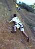
Photo of the rap here > http://hikearizona.com/t2005/05/12/10026-111_18.jpg
There is a bypass on creek right if you climb up and around the pouroff.
If there's enough water, jumping into the pool below is by far the quickest & safest way down. We did use a (mostly unnecessary) handline out to the 2nd (further downstream) anchor point before jumping.Allow my friend Higgs to demonstrate ......!

"The censorship method ... is that of handing the job over to some frail and erring mortal man, and making him omnipotent on the assumption that his official status will make him infallible and omniscient."
George Bernard Shaw
George Bernard Shaw
contribute to this member driven resource
ie: RS > Save/Share after hikes
-
HoffmasterGuides: 0 | Official Routes: 0Triplogs Last: 6,320 d | RS: 0Water Reports 1Y: 0 | Last: never
- Joined: Oct 04 2002 11:13 pm
- City, State: Canton, OH
- Contact:
The spot that AZHiker depicts in his photo is definitely not a downclimb; but it is not the spot I'm talking about. About 10-20 feet to the jumper's left (out of frame in the photo) is an obvious channel that a majority of the water flows down when the fall is flowing. It is probably 15 -20 ft high. It is slightly less than vertical. A person can hold onto a rope, lean back as if rappelling, and keeping their feet smeared on the rock, shimmy down. About 5 ft or so above the water (depending on water level) the angle slackens and the need for a rope is diminished.
The ACA (American Canyoneering Association) would not recommend this approach. They like to use all of the gear they carry. But, a rappel here is unnecessary and extremely time consuming given the short length of it.
The ACA (American Canyoneering Association) would not recommend this approach. They like to use all of the gear they carry. But, a rappel here is unnecessary and extremely time consuming given the short length of it.
"I'm not a vegetarian because I love animals; I'm a vegetarian because I hate plants." A. Whitney Brown
contribute to this member driven resource
ie: RS > Save/Share after hikes
-
HoffmasterGuides: 0 | Official Routes: 0Triplogs Last: 6,320 d | RS: 0Water Reports 1Y: 0 | Last: never
- Joined: Oct 04 2002 11:13 pm
- City, State: Canton, OH
- Contact:
I just noticed that AZHiker included a link to a picture of the rap in his last post. My eyes were selectively reading earlier. Anyway, that's the spot I'm talking about. The photo makes it look worse than it is though, and it is doubtful that you will have that much water flowing.
"I'm not a vegetarian because I love animals; I'm a vegetarian because I hate plants." A. Whitney Brown
contribute to this member driven resource
ie: RS > Save/Share after hikes
-
HoffmasterGuides: 0 | Official Routes: 0Triplogs Last: 6,320 d | RS: 0Water Reports 1Y: 0 | Last: never
- Joined: Oct 04 2002 11:13 pm
- City, State: Canton, OH
- Contact:
contribute to this member driven resource
ie: RS > Save/Share after hikes