 Route Editor

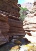
hikes with creeks
Moderator: HAZ - Moderators
Linked Guides none
Linked Area, etc none
-
 sarichterGuides: 0 | Official Routes: 0Triplogs Last: 6,045 d | RS: 0Water Reports 1Y: 0 | Last: never
 - Joined: Dec 25 2008 6:16 pm
- City, State: phoenix, az
hikes with creeks
any good hikes with creeks within 2 hours of phoenix? i know of wet beaver and west clear creek... looking for something to hike this weekend while it's still hot. i would like to avoid huge crowds if possibly [like normal summer party spots]. don't have 4x4 either!
contribute to this member driven resource
ie: RS > Save/Share after hikes 

-
 JoelHazeltonGuides: 16 | Official Routes: 1Triplogs Last: 151 d | RS: 1Water Reports 1Y: 2 | Last: 311 d
 - Joined: Mar 22 2006 7:45 am
- City, State: Phoenix, AZ
- Contact:
Re: hikes with creeks
Cibecue's fun, but costs 15 bucks and is only 2 miles round trip. Or, you can try accessing the Tonto Narrows via Houston Creek and then write it up here. I'm certainly curious about it. West Fork of Oak Creek past the 3 mile mark is nice and the crowds will thin out once you get back there.
"Arizona is the land of contrast... You can go from Minnesota to California in a matter of minutes, then have Mexican food that night." -Jack Dykinga
http://www.joelhazelton.com
http://www.joelhazelton.com
contribute to this member driven resource
ie: RS > Save/Share after hikes
-
 chumleyGuides: 94 | Official Routes: 239Triplogs Last: 11 d | RS: 73Water Reports 1Y: 92 | Last: 10 d
 - Joined: Sep 18 2002 8:59 am
- City, State: Tempe, AZ
Re: hikes with creeks
Horton Creek, and of course, Fossil Springs.
http://www.hikearizona.com/decoder.php?ZTN=62
http://www.hikearizona.com/decoder.php?ZTN=183
Canyon Creek might take a little over 2 hours depending on vehicle and traffic, but worth a look.
http://hikearizona.com/decoder.php?ZTN=928
http://www.hikearizona.com/decoder.php?ZTN=62
http://www.hikearizona.com/decoder.php?ZTN=183
Canyon Creek might take a little over 2 hours depending on vehicle and traffic, but worth a look.
http://hikearizona.com/decoder.php?ZTN=928
I'm not sure what my spirit animal is, but I'm confident it has rabies.
contribute to this member driven resource
ie: RS > Save/Share after hikes
-
chumleyGuides: 94 | Official Routes: 239Triplogs Last: 11 d | RS: 73Water Reports 1Y: 92 | Last: 10 d
- Joined: Sep 18 2002 8:59 am
- City, State: Tempe, AZ
Re: hikes with creeks
Of course, its good to remind people about TrailDEX. Select "perennial" from the pull-down menu for "creek" and then select the area of the state you are willing to go to. Start with "Phoenix" for the closest, but you might look at Payson, Prescott, Sedona, or even Tucson areas for hikes within 2 hours. Some of the hikes in those regions are further than two hours, but there's plenty to choose from.
TrailDEX is accessed from a link on the top of the page, and takes you here:
http://hikearizona.com/interestDEX.php?ID=34
TrailDEX is accessed from a link on the top of the page, and takes you here:
http://hikearizona.com/interestDEX.php?ID=34
I'm not sure what my spirit animal is, but I'm confident it has rabies.
contribute to this member driven resource
ie: RS > Save/Share after hikes
-
sarichterGuides: 0 | Official Routes: 0Triplogs Last: 6,045 d | RS: 0Water Reports 1Y: 0 | Last: never
- Joined: Dec 25 2008 6:16 pm
- City, State: phoenix, az
Re: hikes with creeks
thanks! i'm going to hit the Narrows this weekend... and then possibly some of the others the following weekends.
contribute to this member driven resource
ie: RS > Save/Share after hikes
-
 joebartelsGuides: 264 | Official Routes: 224Triplogs Last: 2 d | RS: 2067Water Reports 1Y: 29 | Last: 2 d
 - Joined: Nov 20 1996 12:00 pm
Re: hikes with creeks
I almost tagged onto that one. However the best part is swimming up the creek to the waterfall!
- joe
contribute to this member driven resource
ie: RS > Save/Share after hikes
-
sarichterGuides: 0 | Official Routes: 0Triplogs Last: 6,045 d | RS: 0Water Reports 1Y: 0 | Last: never
- Joined: Dec 25 2008 6:16 pm
- City, State: phoenix, az
Re: hikes with creeks
well it's supposed to get up to 116 thereabouts on the desert floor... i'm going to see how far i can get before my blood begins to boil in or out of the water. besides, i don't have a drypack so i'm going to have to get creative and only bring things i don't mind getting wet!joe bartels wrote:I almost tagged onto that one. However the best part is swimming up the creek to the waterfall!
contribute to this member driven resource
ie: RS > Save/Share after hikes
-
JoelHazeltonGuides: 16 | Official Routes: 1Triplogs Last: 151 d | RS: 1Water Reports 1Y: 2 | Last: 311 d
- Joined: Mar 22 2006 7:45 am
- City, State: Phoenix, AZ
- Contact:
Re: hikes with creeks
Are you going in from Houston Creek? Any other access you're looking at?
"Arizona is the land of contrast... You can go from Minnesota to California in a matter of minutes, then have Mexican food that night." -Jack Dykinga
http://www.joelhazelton.com
http://www.joelhazelton.com
contribute to this member driven resource
ie: RS > Save/Share after hikes
-
sarichterGuides: 0 | Official Routes: 0Triplogs Last: 6,045 d | RS: 0Water Reports 1Y: 0 | Last: never
- Joined: Dec 25 2008 6:16 pm
- City, State: phoenix, az
Re: hikes with creeks
i'm only going to follow the write up from joe. where do i access houston creek to get into the narrows? further north up the highway? i don't mind doing a little adventure hiking but i certainly don't want to try something that is going to damage my carazpride wrote:Are you going in from Houston Creek? Any other access you're looking at?
contribute to this member driven resource
ie: RS > Save/Share after hikes
-
JoelHazeltonGuides: 16 | Official Routes: 1Triplogs Last: 151 d | RS: 1Water Reports 1Y: 2 | Last: 311 d
- Joined: Mar 22 2006 7:45 am
- City, State: Phoenix, AZ
- Contact:
Re: hikes with creeks
The reason I suggested Houston Creek was because the normal access to the Tonto Narrows (which goes through private property) is closed. Apparently there's a sign there suggesting accessing from Houston Creek.
"Arizona is the land of contrast... You can go from Minnesota to California in a matter of minutes, then have Mexican food that night." -Jack Dykinga
http://www.joelhazelton.com
http://www.joelhazelton.com
contribute to this member driven resource
ie: RS > Save/Share after hikes
-
sarichterGuides: 0 | Official Routes: 0Triplogs Last: 6,045 d | RS: 0Water Reports 1Y: 0 | Last: never
- Joined: Dec 25 2008 6:16 pm
- City, State: phoenix, az
Re: hikes with creeks
yeah i read that. i assume you can still go through it without being shotazpride wrote:The reason I suggested Houston Creek was because the normal access to the Tonto Narrows (which goes through private property) is closed. Apparently there's a sign there suggesting accessing from Houston Creek.
contribute to this member driven resource
ie: RS > Save/Share after hikes
-
sarichterGuides: 0 | Official Routes: 0Triplogs Last: 6,045 d | RS: 0Water Reports 1Y: 0 | Last: never
- Joined: Dec 25 2008 6:16 pm
- City, State: phoenix, az
Re: hikes with creeks
ok... now reading more it does seem illegal to cross the normal area on private property. however, i see two options... taking sandy wash up to the north and connecting with Houston Creek [seems shorter than driving to Payson, but i'm not sure about road conditions] and the other is that alternate road along Gisela Road. i think i may drive the 'beast' up there and try some off roading if it isn't too sandy... the honda should be light enough to make it around some of that area. anyone have any other options or suggestions?
contribute to this member driven resource
ie: RS > Save/Share after hikes
-
 joshvk121Guides: 0 | Official Routes: 0Triplogs Last: none | RS: 0Water Reports 1Y: 0 | Last: never
 - Joined: Jul 05 2009 1:18 pm
- City, State: mesa
Re: hikes with creeks
If you tryi going down gisela when it fork to the right down to the creek please post and let me know how it turns out.. Plannig on going this way in august... Not sure if your aloud to park along this road. If you cant we will just get dropped off at this road a picked up..sarichter wrote:ok... now reading more it does seem illegal to cross the normal area on private property. however, i see two options... taking sandy wash up to the north and connecting with Houston Creek [seems shorter than driving to Payson, but i'm not sure about road conditions] and the other is that alternate road along Gisela Road. i think i may drive the 'beast' up there and try some off roading if it isn't too sandy... the honda should be light enough to make it around some of that area. anyone have any other options or suggestions?
contribute to this member driven resource
ie: RS > Save/Share after hikes