 Route Editor

I know the main TH access to the Tonto Narrows is now closed. We are looking for some alternate routes to get back there for a dayhike. Anyone know of a good TH or access point to hike back there now?
Thanks!
Admin edit: use this route
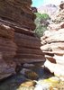
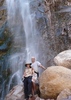
Tonto Narrows Access
Moderator: HAZ - Moderators
Linked Area, etc none
-
 mcopleaGuides: 0 | Official Routes: 0Triplogs Last: 6,324 d | RS: 0Water Reports 1Y: 0 | Last: 6,330 d
 - Joined: May 18 2008 9:47 pm
- City, State: Chandler, AZ
contribute to this member driven resource
ie: RS > Save/Share after hikes 

-
 joebartelsGuides: 264 | Official Routes: 224Triplogs Last: 3 d | RS: 2065Water Reports 1Y: 28 | Last: 15 d
 - Joined: Nov 20 1996 12:00 pm
Re: Tonto Narrows Access
Just because it isn't private doesn't mean it's free to public roaming. Being in the Tonto National Forest you would think it is, but that may be a dicey area. Regardless of who owns it, if it says "access denied", "stay out" or similar that's the right of the owner be it a private party or government. Keep us posted as to what you find.
- Attachments
-
- joe
contribute to this member driven resource
ie: RS > Save/Share after hikes
-
 azdesertfatherGuides: 16 | Official Routes: 21Triplogs Last: 8 d | RS: 18Water Reports 1Y: 2 | Last: 330 d
 - Joined: Apr 30 2008 9:57 am
- City, State: Tucson, AZ
- Contact:
Re: Tonto Narrows Access
yep, totally. thanks for saying that. will be interesting to see if the private landowner has done something on the public land to scare off attempters, too?joe bartels wrote:Just because it isn't private doesn't mean it's free to public roaming. Being in the Tonto National Forest you would think it is, but that may be a dicey area. Regardless of who owns it, if it says "access denied", "stay out" or similar that's the right of the owner be it a private party or government. Keep us posted as to what you find.
"I went to the woods because I wished to live deliberately, to front only the essential facts of life, and see if I could not learn what it had to teach, and not, when I came to die, discover that I had not lived." — Henry David Thoreau
contribute to this member driven resource
ie: RS > Save/Share after hikes
-
 joshvk121Guides: 0 | Official Routes: 0Triplogs Last: none | RS: 0Water Reports 1Y: 0 | Last: never
 - Joined: Jul 05 2009 1:18 pm
- City, State: mesa
Re: Tonto Narrows Access
They payson ranger station said as long as you stay off the property you can go where you want....
contribute to this member driven resource
ie: RS > Save/Share after hikes
-
joebartelsGuides: 264 | Official Routes: 224Triplogs Last: 3 d | RS: 2065Water Reports 1Y: 28 | Last: 15 d
- Joined: Nov 20 1996 12:00 pm
contribute to this member driven resource
ie: RS > Save/Share after hikes
-
joshvk121Guides: 0 | Official Routes: 0Triplogs Last: none | RS: 0Water Reports 1Y: 0 | Last: never
- Joined: Jul 05 2009 1:18 pm
- City, State: mesa
Re: Tonto Narrows Access
No worry.. I was just wondering if anyone had ventured in this way.. and what people thought about possibly going this way
contribute to this member driven resource
ie: RS > Save/Share after hikes
-
joebartelsGuides: 264 | Official Routes: 224Triplogs Last: 3 d | RS: 2065Water Reports 1Y: 28 | Last: 15 d
- Joined: Nov 20 1996 12:00 pm
contribute to this member driven resource
ie: RS > Save/Share after hikes
-
joshvk121Guides: 0 | Official Routes: 0Triplogs Last: none | RS: 0Water Reports 1Y: 0 | Last: never
- Joined: Jul 05 2009 1:18 pm
- City, State: mesa
Re: Tonto Narrows Access
with my luck there be some redneck shootin beer bottels on his land
contribute to this member driven resource
ie: RS > Save/Share after hikes
-
azdesertfatherGuides: 16 | Official Routes: 21Triplogs Last: 8 d | RS: 18Water Reports 1Y: 2 | Last: 330 d
- Joined: Apr 30 2008 9:57 am
- City, State: Tucson, AZ
- Contact:
Re: Tonto Narrows Access
target practice for the next guy who shows up out there to swim?!joshvk121 wrote:with my luck there be some redneck shootin beer bottels on his land
"I went to the woods because I wished to live deliberately, to front only the essential facts of life, and see if I could not learn what it had to teach, and not, when I came to die, discover that I had not lived." — Henry David Thoreau
contribute to this member driven resource
ie: RS > Save/Share after hikes
-
joshvk121Guides: 0 | Official Routes: 0Triplogs Last: none | RS: 0Water Reports 1Y: 0 | Last: never
- Joined: Jul 05 2009 1:18 pm
- City, State: mesa
contribute to this member driven resource
ie: RS > Save/Share after hikes
-
joshvk121Guides: 0 | Official Routes: 0Triplogs Last: none | RS: 0Water Reports 1Y: 0 | Last: never
- Joined: Jul 05 2009 1:18 pm
- City, State: mesa
Re: Tonto Narrows Access
"Get bosy livin or get busy dying" Shawshank redemption
contribute to this member driven resource
ie: RS > Save/Share after hikes
-
joshvk121Guides: 0 | Official Routes: 0Triplogs Last: none | RS: 0Water Reports 1Y: 0 | Last: never
- Joined: Jul 05 2009 1:18 pm
- City, State: mesa
Re: Tonto Narrows Access
I cant spell .... wonk wonk wonk
contribute to this member driven resource
ie: RS > Save/Share after hikes
-
 sarichterGuides: 0 | Official Routes: 0Triplogs Last: 6,042 d | RS: 0Water Reports 1Y: 0 | Last: never
 - Joined: Dec 25 2008 6:16 pm
- City, State: phoenix, az
Re: Tonto Narrows Access
don't worry guys... i'm going there sunday, i'll be the first to be shot! i'm taking that southern route if i can park my car without being towed!
p.s. who needs GPS? just remember, up is always north and down is always south
p.s. who needs GPS? just remember, up is always north and down is always south
contribute to this member driven resource
ie: RS > Save/Share after hikes
-
 Xiled1Guides: 0 | Official Routes: 0Triplogs Last: 2,165 d | RS: 0Water Reports 1Y: 0 | Last: 5,514 d
 - Joined: Feb 26 2009 10:59 am
- City, State: Mesa, AZ
Re: Tonto Narrows Access
If you look at the area on Google earth, you can see a number of rabbit/4X4 trails that lead North from the main road. You could head up one of these and park and then make your way back down to the narrows, probably looking at a 3 mile hike. But, when I compared to the Tonto map, none of those roads are posted as designated FR's. If I was going to head up there again, I would call the Payson ranger district and get a read on how strict they are on towing. I believe if you ask anyone in Gisela, they are going to tell you to go away and take your Teva's with you.
contribute to this member driven resource
ie: RS > Save/Share after hikes
-
mcopleaGuides: 0 | Official Routes: 0Triplogs Last: 6,324 d | RS: 0Water Reports 1Y: 0 | Last: 6,330 d
- Joined: May 18 2008 9:47 pm
- City, State: Chandler, AZ
Re: Tonto Narrows Access
Good points. But, I would tell the locals that I don't own any Teva's... just Keen's! :-)Xiled1 wrote: If I was going to head up there again, I would call the Payson ranger district and get a read on how strict they are on towing. I believe if you ask anyone in Gisela, they are going to tell you to go away and take your Teva's with you.
contribute to this member driven resource
ie: RS > Save/Share after hikes
-
sarichterGuides: 0 | Official Routes: 0Triplogs Last: 6,042 d | RS: 0Water Reports 1Y: 0 | Last: never
- Joined: Dec 25 2008 6:16 pm
- City, State: phoenix, az
Re: Tonto Narrows Access
hmmm. thats my second choice, going north along sandy wash. if there is no sign, they can't legally tow you so i'll keep my eyes open for them.
contribute to this member driven resource
ie: RS > Save/Share after hikes
-
sarichterGuides: 0 | Official Routes: 0Triplogs Last: 6,042 d | RS: 0Water Reports 1Y: 0 | Last: never
- Joined: Dec 25 2008 6:16 pm
- City, State: phoenix, az
Re: Tonto Narrows Access
Xiled1 wrote:If you look at the area on Google earth, you can see a number of rabbit/4X4 trails that lead North from the main road. You could head up one of these and park and then make your way back down to the narrows, probably looking at a 3 mile hike. But, when I compared to the Tonto map, none of those roads are posted as designated FR's. If I was going to head up there again, I would call the Payson ranger district and get a read on how strict they are on towing. I believe if you ask anyone in Gisela, they are going to tell you to go away and take your Teva's with you.
ok those rabbit roads along sand wash are FS roads... 590 and 208 specifically. i can access Houston Creek from there... however the Payson Ranger station mentioned that you could possibly access the narrows from near that private property [further south] but i would have to find a safe place to park... one that is technically on a FS road... seeing that there really aren't any there, i will have to get creative. there is an unmarked trail that heads to Gisela Mtn, so i'm sure i can bushwack north east from that trail head to access the Narrows way quicker than dealing with the dirt road up to Houston Creek. i'll post what happens... that is if i don't get killed
contribute to this member driven resource
ie: RS > Save/Share after hikes
-
 BobPGuides: 2 | Official Routes: 17Triplogs Last: 2 d | RS: 58Water Reports 1Y: 0 | Last: 459 d
 - Joined: Feb 26 2008 3:43 pm
- City, State: Scottsdale, AZ
Re: Tonto Narrows Access
+1mcoplea wrote:just Keen's!
https://www.seeitourway.org
Always pronounce Egeszsegedre properly......
If you like this triplog you must be a friend of BrunoP
Always pronounce Egeszsegedre properly......
If you like this triplog you must be a friend of BrunoP
contribute to this member driven resource
ie: RS > Save/Share after hikes
-
sarichterGuides: 0 | Official Routes: 0Triplogs Last: 6,042 d | RS: 0Water Reports 1Y: 0 | Last: never
- Joined: Dec 25 2008 6:16 pm
- City, State: phoenix, az
contribute to this member driven resource
ie: RS > Save/Share after hikes
-
joshvk121Guides: 0 | Official Routes: 0Triplogs Last: none | RS: 0Water Reports 1Y: 0 | Last: never
- Joined: Jul 05 2009 1:18 pm
- City, State: mesa
Re: Tonto Narrows Access
Good let me know if you can park there.. someone said that road was boulderd off.
contribute to this member driven resource
ie: RS > Save/Share after hikes
-
sarichterGuides: 0 | Official Routes: 0Triplogs Last: 6,042 d | RS: 0Water Reports 1Y: 0 | Last: never
- Joined: Dec 25 2008 6:16 pm
- City, State: phoenix, az
Re: Tonto Narrows Access
joshvk121 wrote:Good let me know if you can park there.. someone said that road was boulderd off.
i thought they meant the one that keeps going on the north side of the creek was bouldered off... if so, there are some trailheads just south of that fork, so i plan on driving back and finding a safe parking space there. i'm determined to find a route!
contribute to this member driven resource
ie: RS > Save/Share after hikes