 Route Editor

Just got in late last night (early this a.m. actually) from a fantastic hike to Tapeats Creek with Zenphx and GTG. The trip stretched from 10/15 (leave Phx and bunk at the N. Rim) to 10/21 (hike out from the Esplanade, shower and gorge ourselves on Grand Bull burgers at Jacob Lake, and get back to Phx). This was a beautiful experience in a remote and very rugged place. GTG and Zenphx are great hiking partners with wonderful experiences, stories, jokes, and knowledge to share. I recommend hiking with them at any opportunity.
Our route followed the Bill Hall trail to Thunder River trail to Tapeats Creek (10.5 miles). We made camp at upper Tapeats and explored from there. Zenphx spent most of his time fly fishing and hiking around to different spots to do same. GTG and I made 2 side trips. First, down Tapeats creek to the Colorado and back slowly to sightsee and take photos, I believe it was about 6 miles round trip. If not GTG can correct me on this. This hike was reasonbly easy but did include several water crossings in fairly fast water (I was thankful for the use of one of GTG's trekking poles for the fords) as well as some high exposure on narrow trails. The exposure was a little nerve wracking in places but we managed. Our second trip was a loop down Tapeats, down the Colorado to Deer Creek, down/up the narrows of Deer creek, up Deer creek to the spring, up the canyon to Suprise Valley, across the valley to Thunder River, and back down Thunder river/Tapeats canyon to camp. Wow, I'm tired just typing it out. This trip was very rugged and very exposed and very beautiful. While I can't imagine it carrying a full pack (we just had daypacks) I'm already contemplating it and scheming the particulars. Our calculations for this hike was about 10 1/2 miles, but we now think it was somewhat longer. It is more of a route than a trail along the river and we spent a lot of time routefinding and experienced added distance crossing drainages.
Because I'm technologically challenged it may take me awhile to get all the photos edited and posted. I will put a few of the better ones in directly and a I'm sure the other guys will get their stuff in pretty quickly.
thunder river/tapeats backpack
Moderators: Backpack Specialist, HAZ - Moderators
Linked Area, etc none
-
 mtoomeyazGuides: 0 | Official Routes: 0Triplogs Last: 8,626 d | RS: 0Water Reports 1Y: 0 | Last: never
 - Joined: Apr 09 2002 7:08 am
- City, State: Gilbert, AZ
thunder river/tapeats backpack
Mike T
-------------------------------------------------
Less is more
-------------------------------------------------
Less is more
contribute to this member driven resource
ie: RS > Save/Share after hikes 

-
 MaryPhylGuides: 0 | Official Routes: 0Triplogs Last: 9,338 d | RS: 0Water Reports 1Y: 0 | Last: never
 - Joined: Apr 29 2002 7:58 am
- City, State: Flagstaff, AZ
contribute to this member driven resource
ie: RS > Save/Share after hikes
-
 zenphxGuides: 0 | Official Routes: 0Triplogs Last: none | RS: 0Water Reports 1Y: 0 | Last: never
 - Joined: Apr 12 2002 10:32 am
- City, State: Phoenix, AZ
My Two Cents
I have to echo Mike's sentiments. I've been down to Thunder river 7 or 8 times now, with various people and groups and I must say that I've never had better hiking companions than Mike and Todd. They're very considerate, and companionable guys. I especially appreciated that they, without a hint of complaint, adjusted to my sometimes slow pace.
One of the neat things about this hike is that we all had digital cameras, so there are lots of pictures to share and to post here. I just need to get to them to select/edit/compress/submit .....
Speaking of cameras, I was the techno-geek of the trip with my 5 Mpixel Nikon. I'm not bragging but setting the stage for the little story about the one fateful picture I snapped while we were barely into the trip. Down on the Esplanade, a red rock plateau 1000 ft below the rim, I decided to stop and take a picture of a part of the first cliff face.....a butte called Bridger's Knoll. Kneeling carefully with my 60 lb pack and lining the knoll up behind some lovely Agave stalks, I got one of my best pictures of Bridger's. What I didn't realize was that, at 56, and even with the assist of a walking stick, getting up from that kneeling position Might be a problem. I knew my pack was top heavy, especially with the 2+ liters of water in a soft pack up top. But somehow I was still surprised as I pushed hard on the walking stick to stand, only to find myself staggering and stumbling backwards for what seemed like 5 minutes. As it always happens in this situations, just when I felt like I've won the battle with gravity, I went crashing onto the hard redrock. I don't swear often, but this was one of those times. Mike and Todd must have thought I broke something important, because they ran over in alarm and were anxious about a possible injury. (If we had been at the bottom, getting carried out might not have been a bad 'concept'.....) BUT, it wasn't my butt that I broke, nor, alas, my arm. It seems I broke the fall with my 5 Mpixel Nikon. The lens, fully extended for the picture, was very much askew, and frozen in place. Several power cycles of the camera proved that that lens had had it's last erection. Hence the swearing.......I had 4 days to spend in the Canyon and I had just wrecked my camera. God knows, I would have rather broken my arm!!
BUT........there is a happy ending. After some careful examination and after taking a deep breath, I executed a maneuver similar to popping a dislocated shoulder back in place; ........and the lens was Alive!! It was Alive!! The dang thing even focused well!! Todd and Mike kept asking if I were 'Ok'. "He.ll, I don't care....the camera is Alive!!!....."
Anyway, the lesson here is: Don't squat down with a 60 lb pack ..... Duh.....!! But, I did get many wonderful pictures and I'll looking forward to sharing them with Mike and Todd and everyone here.
Also, I'm considering......and Mike and Todd support this.......changing my nickname to.......
RockDancer (WhadyaThink?)
Lastly; some philosophy that hit home after completing this beautiful and arduous hike:
From the book Zen Judaism ..... (no kidding....):
A Journey of a Thousand Miles Begins With a Single .............. Oy.............
Lastly (really). I'm posting the Bridger's Knoll picture.....and will post others soon.
That Was Zen; This is Tao
contribute to this member driven resource
ie: RS > Save/Share after hikes
-
 scottmackeyGuides: 0 | Official Routes: 0Triplogs Last: 8,285 d | RS: 0Water Reports 1Y: 0 | Last: never
 - Joined: Oct 10 2002 2:27 pm
- City, State: Tempe, AZ

contribute to this member driven resource
ie: RS > Save/Share after hikes
-
MaryPhylGuides: 0 | Official Routes: 0Triplogs Last: 9,338 d | RS: 0Water Reports 1Y: 0 | Last: never
- Joined: Apr 29 2002 7:58 am
- City, State: Flagstaff, AZ
Aaaargh!!! What did you have in that pack that would make it weigh 60 pounds? I made the same trip last year with 23 pounds--even if you eat and drink a lot more than I do you should not have had anywhere near that much. Please, weigh everything you have and list it and then get rid of everything you did not use.
contribute to this member driven resource
ie: RS > Save/Share after hikes
-
zenphxGuides: 0 | Official Routes: 0Triplogs Last: none | RS: 0Water Reports 1Y: 0 | Last: never
- Joined: Apr 12 2002 10:32 am
- City, State: Phoenix, AZ
contribute to this member driven resource
ie: RS > Save/Share after hikes
-
 sidhayesGuides: 1 | Official Routes: 0Triplogs Last: 3,893 d | RS: 0Water Reports 1Y: 0 | Last: never
 - Joined: Feb 04 2002 10:17 am
contribute to this member driven resource
ie: RS > Save/Share after hikes
-
MaryPhylGuides: 0 | Official Routes: 0Triplogs Last: 9,338 d | RS: 0Water Reports 1Y: 0 | Last: never
- Joined: Apr 29 2002 7:58 am
- City, State: Flagstaff, AZ
Of course he can carry anything he wishes but it was not good for him and it was not safe. I too am 56 and the body is not as strong as a kid's no matter what shape you are in. A heavy pack makes you top heavy. This is OK on a trail in City Park but on rough ground one's balance is not good and one's ability to react gracefully to surprises (like that rock that rolls out from under you) is compromised. A heavy pack means much slower hiking which increases water needs which increases pack weight even further. There really is a happy medium where you have all the gear and food you need without overburdening yourself.sidhayes wrote:Cannot zenphx take along anything he wishes? After all, he carries it, and the hike seemed to go very well.
contribute to this member driven resource
ie: RS > Save/Share after hikes
-
sidhayesGuides: 1 | Official Routes: 0Triplogs Last: 3,893 d | RS: 0Water Reports 1Y: 0 | Last: never
- Joined: Feb 04 2002 10:17 am
A 56 year olds body could be stronger and have more endurance than he had in his youth. The exception to this would be if he was a high level athlete .Otherwise, I see older people all the time who have much better conditioning now than when they were younger. His pack, however heavy, would not have to be top heavy; perhaps he packed heavier objects lower in his pack. As to pack weight, 23 pounds is certainly light but I did most of that route carrying less than five pounds. I did it in the morning and did not stay overnight. zenphx seemed, by all accounts, seemed to have done just fine carrying what he had. 
contribute to this member driven resource
ie: RS > Save/Share after hikes
-
MaryPhylGuides: 0 | Official Routes: 0Triplogs Last: 9,338 d | RS: 0Water Reports 1Y: 0 | Last: never
- Joined: Apr 29 2002 7:58 am
- City, State: Flagstaff, AZ
contribute to this member driven resource
ie: RS > Save/Share after hikes
-
sidhayesGuides: 1 | Official Routes: 0Triplogs Last: 3,893 d | RS: 0Water Reports 1Y: 0 | Last: never
- Joined: Feb 04 2002 10:17 am
contribute to this member driven resource
ie: RS > Save/Share after hikes
-
 WizGuides: 0 | Official Routes: 0Triplogs Last: 8,598 d | RS: 0Water Reports 1Y: 0 | Last: never
 - Joined: May 22 2002 3:15 am
- City, State: Phoenix, AZ
Whoa, let's everyone step back and be civil!
Good camera story, Zenphx! And I like this nickname much better than RockDancer. RockDancer sounds kind of "eh!"
I tend to carry a heavy pack, too, despite my best intentions. I agree with MaryPhyl that you should get rid of everything you don't need; the problem is I NEED all that stuff!
Good camera story, Zenphx! And I like this nickname much better than RockDancer. RockDancer sounds kind of "eh!"
I tend to carry a heavy pack, too, despite my best intentions. I agree with MaryPhyl that you should get rid of everything you don't need; the problem is I NEED all that stuff!
"The older I get, the better I was."
contribute to this member driven resource
ie: RS > Save/Share after hikes
-
zenphxGuides: 0 | Official Routes: 0Triplogs Last: none | RS: 0Water Reports 1Y: 0 | Last: never
- Joined: Apr 12 2002 10:32 am
- City, State: Phoenix, AZ
Controversy
Sorry, didn't mean to start a controversy.
Todd and Mike and I went over a checklist very carefully. So, none of us felt we brought anything that was unnecessary. Also, we were down there for 5 days; that's a fair bit of food. Also, Thunder River Spring is the first water source on the hike. And it's about 9 miles from the trailhead. Also, we split the ascent over two days. Therefore, we cached 3 liters of water each on the Esplanade. Therefore, we were each carrying about 6 liters of water on the way down; plus food plus all the usual gear. Anyway, each of our packs was at or near 60lbs. (Mike or Todd can correct me if I'm wrong....). One 'issue' with my pack was, in addition to the weight, was the water I was carrying in a platypus bladder at the very top of the pack. This did make the pack top heavy and probably contributed to the instability. I'd recommend putting those things on the side or back of the pack in their own sack (Camelpak style). I think that's how Mike and Todd's packs were rigged.
I'm always looking to 'lighten' the load, especially on long, arduous hikes like this.
(I just didn't think that the 2 bottles of Merlot and Cabernet would be that big a deal......
Also, I agree about 'Rockdancer'. I'll keep Zenphx
That Was Zen; This is Tao
contribute to this member driven resource
ie: RS > Save/Share after hikes
-
mtoomeyazGuides: 0 | Official Routes: 0Triplogs Last: 8,626 d | RS: 0Water Reports 1Y: 0 | Last: never
- Joined: Apr 09 2002 7:08 am
- City, State: Gilbert, AZ
contribute to this member driven resource
ie: RS > Save/Share after hikes
-
 evenstarx3Guides: 1 | Official Routes: 0Triplogs Last: 8,555 d | RS: 0Water Reports 1Y: 0 | Last: never
 - Joined: Feb 03 2002 8:44 am
- City, State: Sun City West, AZ from CA
Well, knowing GTG, he probably slipped a case of cheap (Keep tellin' him the good stuff's lighter 'cause of more bubbles!) beer into zenphx's pack which explains why he, zenphx, fell on his a**! Of course it wouldn't surprise me if GTG tripped zenphx! No, wait....that's not right.....I happen to know GTG likes his beer in bottles and no way would he chance a bottle bein' broken! Hey zenphx...did GTG by any chance throw a pillow or any kind of cushioning under you just as you started to fall!!!!! He is a sneaky devil....snuck all the identifying stuff off kurthzone's car so Stan woundn't know what kind of car it was!
Hooli, aka Trihairopelli
"They say the dog is man's best friend.
I don't believe that. How many of your friends have you neutered?"
--Larry Reeb
"They say the dog is man's best friend.
I don't believe that. How many of your friends have you neutered?"
--Larry Reeb
contribute to this member driven resource
ie: RS > Save/Share after hikes
-
zenphxGuides: 0 | Official Routes: 0Triplogs Last: none | RS: 0Water Reports 1Y: 0 | Last: never
- Joined: Apr 12 2002 10:32 am
- City, State: Phoenix, AZ
Well, That Was IT!
Ya know, I forgot about the dang barcalounger. And I remember now that once I had decided on bringing that, it was a tough choice on the Yukon Jack. One bottle or two .... ? Well, since I wasn't planning on carrying any of the contents back up, it was TWO !!
Next year, let's forget about caching water on the Esplanade. I think caching two liters of Yukon Jack each will get us up and out-o-there much more efficiently.......
Next year, let's forget about caching water on the Esplanade. I think caching two liters of Yukon Jack each will get us up and out-o-there much more efficiently.......
That Was Zen; This is Tao
contribute to this member driven resource
ie: RS > Save/Share after hikes
-
 GTG_AZHGuides: 1 | Official Routes: 0Triplogs Last: 8,472 d | RS: 0Water Reports 1Y: 0 | Last: never
 - Joined: Feb 03 2002 11:45 am
- City, State: Peoria, AZ - Originally from Rocket City USA
Well
I have stayed out of this one too long. If Hooli posts to the thread about a trip I went on, before me, there's something serious wrong.
I had quite the workload waiting for me when I got back.
Things are much simpler in that hole in the ground.
I'll agree with mike t and zenphx, this was an absolutely awesome trip. Almost nothing else could have happened to make it more perfect. The entire trip has something to behold. The burned out area at Monument Point, climbing down past Bridgers Knoll to see the canyon open up for miles northwest away from the river. The very sight of the canyon opening up that wide was almost a frighteneing sight for me. Across the Esplanade with it's Sedona-like rock formations. Down the face of the mighty Redwall. Across Surprise Valley up the last hill to hear the roar of Thunder River, continuing on down to Tapeats Creek and the Thunder River confluence. Crossing both at dusk, and then hiking to one of the coolest campsites you could imagine.
mike t and I did the loop from Tapeats Creek, down to the Colorado River, taking the river route to Deer Creek/Springs and then back to Tapeats Creek via Surprise Valley. This hike deserves a description soon.
I hope to get a description posted of the trails taken on this trip, with the help of some who have been on this trip as well. This is truly an unforgettable hike, if given the chance to go, make sure you do.
Some good quotes from the trip -
The hiker's prayer -
"Lord, if you pick 'em up, we'll put 'em down."
"Damn dirty rafters." (Spit)
"That's not a helicopter, that's my heart."
"Lord, if you're with me now, you've got to go in front of me, or behind me, there ain't room for us side by side on this ledge."
"I don't smell a thing."
For some of these you obviously had to be there.
As far as what I carried, I think I used everything except my vinyl bucket, I did pack about three pounds too much trail mix though. The weight of the food and the extra water both ways sure added up quick. This whole trip could be done in a day, we took five days and four nights to round trip. There's gotta be a slow time and a fast time, fortunately we could take our time. As far as the Deer Creek loop, expect to take eleven hours to enjoy it all.
Pictures and more retort to follow soon.
GTG
The boy from Rocket City USA.
'Alright now look over here and smile! and pretend like you're having a good time!'
contribute to this member driven resource
ie: RS > Save/Share after hikes
-
zenphxGuides: 0 | Official Routes: 0Triplogs Last: none | RS: 0Water Reports 1Y: 0 | Last: never
- Joined: Apr 12 2002 10:32 am
- City, State: Phoenix, AZ
And don't forget .....
.......after my particularly 'elegant' descent of that little wall:
"I'll give ya 10 points for Results, but only 2 for Form......"
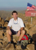
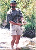
I'm posting a picture of Todd that I like particularly; and yet a few more from the Hike.
"I'll give ya 10 points for Results, but only 2 for Form......"
I'm posting a picture of Todd that I like particularly; and yet a few more from the Hike.
That Was Zen; This is Tao
contribute to this member driven resource
ie: RS > Save/Share after hikes
-
evenstarx3Guides: 1 | Official Routes: 0Triplogs Last: 8,555 d | RS: 0Water Reports 1Y: 0 | Last: never
- Joined: Feb 03 2002 8:44 am
- City, State: Sun City West, AZ from CA
Re: And don't forget .....
zenphx wrote: I'm posting a picture of Todd that I like particularly
Gotta be this one, right? http://hikearizona.com/phoZOOM.php?ZIP=4518
Hooli, aka Trihairopelli
"They say the dog is man's best friend.
I don't believe that. How many of your friends have you neutered?"
--Larry Reeb
"They say the dog is man's best friend.
I don't believe that. How many of your friends have you neutered?"
--Larry Reeb
contribute to this member driven resource
ie: RS > Save/Share after hikes
-
zenphxGuides: 0 | Official Routes: 0Triplogs Last: none | RS: 0Water Reports 1Y: 0 | Last: never
- Joined: Apr 12 2002 10:32 am
- City, State: Phoenix, AZ
That's Great
Yes, I'm proud of that one. It's a particularly good portrait of him.
But if you zoom out slightly, he turns human (or as the Ferengi say: 'Yumon') again.
(It might take a day for Joe to post the Yumon picture. I just submitted several pictures).
But if you zoom out slightly, he turns human (or as the Ferengi say: 'Yumon') again.
(It might take a day for Joe to post the Yumon picture. I just submitted several pictures).
That Was Zen; This is Tao
contribute to this member driven resource
ie: RS > Save/Share after hikes