 Route Editor

Red Picacho/White Picacho
Moderator: HAZ - Moderators
Linked Area, etc none
-
 hippiepunkpirateGuides: 25 | Official Routes: 23Triplogs Last: 502 d | RS: 0Water Reports 1Y: 0 | Last: 3,874 d
 - Joined: May 30 2008 7:43 am
- City, State: Peoria, AZ
- Contact:
Red Picacho/White Picacho
Anybody know anything about climbing the either Red Picacho or White Picacho (or both)? They are adjacent peaks in the Hieroglyphic Mountains west of Lake Pleasant. I haven't been out to even look at them yet, but they caught my eye on the map, and climbing either sounds like a good time. Access via Castle Hot Springs road (second turnoff closer to Wickenburg) looks great. Maximum distance to climb Red Picacho looks like 5 miles RT, but perhaps shorter as it looks like there is at least one spur road that climbs closer up. The TOPO lines look pretty tight on the map, looks like scrambling is likely. That's about all I can figure out from home, any other info would be greatly appreciated. Also, I'd like to get out there, probably a couple weeks from now when my schedule isn't so hectic, on a weekday (early, Monday would be best, if anyone is interested in trying to bag either peak with me maybe we can work something out...
contribute to this member driven resource
ie: RS > Save/Share after hikes 

-
 JoelHazeltonGuides: 16 | Official Routes: 1Triplogs Last: 146 d | RS: 1Water Reports 1Y: 2 | Last: 305 d
 - Joined: Mar 22 2006 7:45 am
- City, State: Phoenix, AZ
- Contact:
Re: Red Picacho/White Picacho
Interesting... I'm intrigued! I love that area. (p.s. Just remembered you texted me the other day about hiking on a Monday in a couple weeks. Was at work and forgot to respond, but I'm down!)
"Arizona is the land of contrast... You can go from Minnesota to California in a matter of minutes, then have Mexican food that night." -Jack Dykinga
http://www.joelhazelton.com
http://www.joelhazelton.com
contribute to this member driven resource
ie: RS > Save/Share after hikes
-
 chumleyGuides: 94 | Official Routes: 239Triplogs Last: 6 d | RS: 73Water Reports 1Y: 95 | Last: 4 d
 - Joined: Sep 18 2002 8:59 am
- City, State: Tempe, AZ
Re: Red Picacho/White Picacho
Looking at the satellite view, both peaks appear to have some pretty good rock climbing at the top. Especially the south (red) peak.
Also, I just looked up the land ownership, and the west side is BLM. Both peaks and the north/east/south are State Trust Land (I'm sure you have your permit ;) ). There's a parcel of private land to the south, which I believe is that spur road you mention as leading to a shorter trip (and a few mines on the topo map). It may or may not be gated. Big Reef Mill area to the northeast (and that road) are not private.
If the road into Trilogy Wash on the west side is a decent road, it might be easier to ascend from that side somewhere.
The State Trust land is on a grazing lease, so you might encounter some very unhappy cows? (unhappy cause there isn't a whole lot of delicious green grass to graze in the area).
- Attachments
-
I'm not sure what my spirit animal is, but I'm confident it has rabies.
contribute to this member driven resource
ie: RS > Save/Share after hikes
-
 The_EagleGuides: 42 | Official Routes: 365Triplogs Last: 9 d | RS: 765Water Reports 1Y: 76 | Last: 16 d
 - Joined: Jan 20 2009 2:46 pm
- City, State: Far NE Phoenix, Az
- Contact:
Re: Red Picacho/White Picacho
Looking at the Satellite Map, It looks like N Castle Hot Springs road, coming up from the South, gets you to within .7 miles of the southern peak.
If you look at 33.95495 -112.507713, it appears there is a truck at the end of the road, alluding to it's drive-able by some sort of vehicle.
If you look at 33.95495 -112.507713, it appears there is a truck at the end of the road, alluding to it's drive-able by some sort of vehicle.
There is a very fine line between "hobby" and "mental illness."
Dave Barry
Dave Barry

contribute to this member driven resource
ie: RS > Save/Share after hikes
-
 PatrickLGuides: 7 | Official Routes: 36Triplogs Last: 45 d | RS: 0Water Reports 1Y: 1 | Last: 236 d
 - Joined: Jan 10 2010 4:25 pm
- City, State: Pomona, CA
- Contact:
Re: Red Picacho/White Picacho
I saw these two on Google Earth a while back and have been interested ever since. I don't recall being able to find pictures of them. Someone posted a triplog and mentioned some technical climbing to reach the top. I'm free on Mondays and interested in making it as far as my comfort zone can go.
http://hikearizona.com/x.php?x=61017
http://hikearizona.com/x.php?x=61017
contribute to this member driven resource
ie: RS > Save/Share after hikes
-
chumleyGuides: 94 | Official Routes: 239Triplogs Last: 6 d | RS: 73Water Reports 1Y: 95 | Last: 4 d
- Joined: Sep 18 2002 8:59 am
- City, State: Tempe, AZ
Re: Red Picacho/White Picacho
Not sure that's a truck, but perhaps some mining equipment? Either way, that road is on private property.coanbru wrote:Looking at the Satellite Map, It looks like N Castle Hot Springs road, coming up from the South, gets you to within .7 miles of the southern peak.
If you look at 33.95495 -112.507713, it appears there is a truck at the end of the road, alluding to it's drive-able by some sort of vehicle.
I'm not sure what my spirit animal is, but I'm confident it has rabies.
contribute to this member driven resource
ie: RS > Save/Share after hikes
-
 mudlugsGuides: 0 | Official Routes: 0Triplogs Last: 1,154 d | RS: 0Water Reports 1Y: 0 | Last: never
 - Joined: Jan 30 2011 5:21 pm
- City, State: Phoenix, AZ
Re: Red Picacho/White Picacho
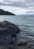
Here's a picture of Red from a hill south and west that had a benchmark on it.

Take Castle Hot Springs to Trilby Wash and drive up the wash to the closest point to your route (looks like coming from the north along the ridge would work.) Don't know about White.
Now looking at the map the picture is more of the ridge next to the peak itself with the peak showing over the top.
Take Castle Hot Springs to Trilby Wash and drive up the wash to the closest point to your route (looks like coming from the north along the ridge would work.) Don't know about White.
Now looking at the map the picture is more of the ridge next to the peak itself with the peak showing over the top.
contribute to this member driven resource
ie: RS > Save/Share after hikes
-
hippiepunkpirateGuides: 25 | Official Routes: 23Triplogs Last: 502 d | RS: 0Water Reports 1Y: 0 | Last: 3,874 d
- Joined: May 30 2008 7:43 am
- City, State: Peoria, AZ
- Contact:
Re: Red Picacho/White Picacho
@mudlugsCool shot! Makes me even more inspired to go check it the area.
@Patrick LThanks for digging up that Red Picacho triplog. Interesting that it mentions a 5.5 technical climb to get to the top of Red. I've never done a technical climb, and am kind of a wuss on exposed stuff to be honest, so it makes me doubtful of myself actually reaching the summit, but I'd like to go check it out anyway. And perhaps White Picacho is an easier summit? Looks doable to go for both in one day, I think. Unfortunately, my schedule is very unfirm so I myself can't set a date for sure to do this, but I'll keep in touch with you guys who are interested (Joel, Patrick, rlrjamy - Bob who PM'd me about it)
@Patrick LThanks for digging up that Red Picacho triplog. Interesting that it mentions a 5.5 technical climb to get to the top of Red. I've never done a technical climb, and am kind of a wuss on exposed stuff to be honest, so it makes me doubtful of myself actually reaching the summit, but I'd like to go check it out anyway. And perhaps White Picacho is an easier summit? Looks doable to go for both in one day, I think. Unfortunately, my schedule is very unfirm so I myself can't set a date for sure to do this, but I'll keep in touch with you guys who are interested (Joel, Patrick, rlrjamy - Bob who PM'd me about it)
contribute to this member driven resource
ie: RS > Save/Share after hikes