 Route Editor

thinking of doing a night or two in November in the Arrastra Mountain Wilderness. There is a jeep trail that runs about 6 miles from HWY 93 to Sycamore Spring. This area is remote and rarely visited by backpackers. Fantastic! Anyone interested?
PS - I know that this is my first real post on the forum, so by way of explanation: I usually backpack/hike solo or with friends outside the forum. I am quite experienced and have done many hikes/backpacks.
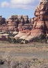
Arrastra Mountain Wilderness
Moderators: Backpack Specialist, HAZ - Moderators
Linked Guides none
Linked Area, etc none
-
 brougham86Guides: 0 | Official Routes: 0Triplogs Last: 4,112 d | RS: 0Water Reports 1Y: 0 | Last: 4,239 d
 - Joined: Aug 05 2010 11:01 am
- City, State: Glendale AZ
contribute to this member driven resource
ie: RS > Save/Share after hikes 

-
 azbackpackrGuides: 34 | Official Routes: 30Triplogs Last: 36 d | RS: 0Water Reports 1Y: 8 | Last: 46 d
 - Joined: Jan 21 2006 6:46 am
- City, State: Eagar AZ
Re: Arrastra Mountain Wilderness
Crazy place. I've been over near there, but not actually to the Arrastras. There are elk in those hills, amazingly enough, and a hunt season, too.
While you're over there you might want to also check out the Bill Williams River hike, accessed from just below the dam at Alamo Lake State Park.
While you're over there you might want to also check out the Bill Williams River hike, accessed from just below the dam at Alamo Lake State Park.
There is a point of no return unremarked at the time in most lives. Graham Greene The Comedians
A clean house is a sign of a misspent life.
A clean house is a sign of a misspent life.
contribute to this member driven resource
ie: RS > Save/Share after hikes
-
 nonotGuides: 107 | Official Routes: 108Triplogs Last: 110 d | RS: 0Water Reports 1Y: 9 | Last: 110 d
 - Joined: Nov 18 2005 11:52 pm
- City, State: Phoenix, AZ
Re: Arrastra Mountain Wilderness
Sounds interesting. Looks like it's either on the roads, or off trail in this area, as I can't locate any evidence of maintained hiking trails in the wilderness.
This hike: http://hikearizona.com/decoder.php?ZTN=1241
appears to be about the closest to the area. If Arrastra Wilderness is anything like Burro Creek Wilderness, it should be mighty fun.
If you get closer to picking a date, and decide you still want company, send me a PM. I have some conflicts, but several of my weekends are free.
http://hikearizona.com/garmin_maps.php
Hike Arizona it is full of sharp, pointy, ankle-twisting, HAZmaster crushing ROCKS!!
Hike Arizona it is full of sharp, pointy, shin-stabbing, skin-shredding plants!
Hike Arizona it is full of striking, biting, stabbing, venomous wildlife!
Hike Arizona it is full of sharp, pointy, ankle-twisting, HAZmaster crushing ROCKS!!
Hike Arizona it is full of sharp, pointy, shin-stabbing, skin-shredding plants!
Hike Arizona it is full of striking, biting, stabbing, venomous wildlife!
contribute to this member driven resource
ie: RS > Save/Share after hikes
-
 HippyGuides: 8 | Official Routes: 1Triplogs Last: 1,085 d | RS: 8Water Reports 1Y: 0 | Last: 1,256 d
 - Joined: Dec 02 2009 10:08 am
- City, State: Grand Canyon
- Contact:
Re: Arrastra Mountain Wilderness
was discussing this briefly last night, somewhere in that area is a 20-25 foot waterfall tucked away into a tiny canyon, i went out there with my dad once for a hike and found frog eggs and all sorts of exciting critters near the fall, been trying to get back for years but haven't been able to find it...lack of a 4x4 vehicle me thinks. I'm in, keep me in the loop.
contribute to this member driven resource
ie: RS > Save/Share after hikes
-
 SredfieldGuides: 4 | Official Routes: 4Triplogs Last: 103 d | RS: 0Water Reports 1Y: 0 | Last: 732 d
 - Joined: Sep 08 2002 1:07 pm
- City, State: Ahwatukee, AZ
Re: Arrastra Mountain Wilderness
there is a piece of private land in the wilderness, but not too far in, that has some water and maybe a fall, it's been a long time since I was there. peeples canyon maybe?
Shawn
The bear went over the mountain to see what he could see.
The bear went over the mountain to see what he could see.
contribute to this member driven resource
ie: RS > Save/Share after hikes
-
brougham86Guides: 0 | Official Routes: 0Triplogs Last: 4,112 d | RS: 0Water Reports 1Y: 0 | Last: 4,239 d
- Joined: Aug 05 2010 11:01 am
- City, State: Glendale AZ
Re: Arrastra Mountain Wilderness
People's Canyon is fed by Sycamore Spring, and flows into the Santa Maria River. Possible waterfall location. This place takes some work to get into for sure, but the jeep trails are walkable. I will keep you all posted on a date.
contribute to this member driven resource
ie: RS > Save/Share after hikes
-
 big_loadGuides: 0 | Official Routes: 1Triplogs Last: 509 d | RS: 3Water Reports 1Y: 0 | Last: 2,712 d
 - Joined: Oct 28 2003 11:20 am
- City, State: Andover, NJ
Re: Arrastra Mountain Wilderness
Kind of an ironic name for private land.brougham86 wrote:People's Canyon
contribute to this member driven resource
ie: RS > Save/Share after hikes
-
HippyGuides: 8 | Official Routes: 1Triplogs Last: 1,085 d | RS: 8Water Reports 1Y: 0 | Last: 1,256 d
- Joined: Dec 02 2009 10:08 am
- City, State: Grand Canyon
- Contact:
Re: Arrastra Mountain Wilderness
why walk jeep roads when i have a perfectly bad arse subaru at my disposal  i'm down for some off roadin'. just gotta figure out when. and if my subaru can't make it i'm sure i know a few other crazies who would enjoy the drive in with their off roadin vehicles
@brougham86 tell me the exact area you're considering and i'll pick some brains see if my suby can make it and such and we'll go from there
@brougham86 tell me the exact area you're considering and i'll pick some brains see if my suby can make it and such and we'll go from there
Last edited by Hippy on Oct 19 2012 1:28 pm, edited 1 time in total.
contribute to this member driven resource
ie: RS > Save/Share after hikes
-
 chumleyGuides: 94 | Official Routes: 239Triplogs Last: 5 d | RS: 73Water Reports 1Y: 95 | Last: 4 d
 - Joined: Sep 18 2002 8:59 am
- City, State: Tempe, AZ
Re: Arrastra Mountain Wilderness
Um. Cause it's a "wilderness area"?HippyHaley wrote:why walk jeep roads when i have a perfectly bad arse subaru at my disposal
I'm not sure what my spirit animal is, but I'm confident it has rabies.
contribute to this member driven resource
ie: RS > Save/Share after hikes
-
HippyGuides: 8 | Official Routes: 1Triplogs Last: 1,085 d | RS: 8Water Reports 1Y: 0 | Last: 1,256 d
- Joined: Dec 02 2009 10:08 am
- City, State: Grand Canyon
- Contact:
Re: Arrastra Mountain Wilderness
@chumley you hush! it's BLM there are no driving restrictions in place so 
contribute to this member driven resource
ie: RS > Save/Share after hikes
-
 joebartelsGuides: 264 | Official Routes: 224Triplogs Last: 3 d | RS: 2064Water Reports 1Y: 28 | Last: 13 d
 - Joined: Nov 20 1996 12:00 pm
Re: Arrastra Mountain Wilderness
the trail side bartender speaks the truth
Wilderness Act 1964 mechanical transport is banned
map for those interested in this wilderness
Wilderness Act 1964 mechanical transport is banned
map for those interested in this wilderness
- joe
contribute to this member driven resource
ie: RS > Save/Share after hikes
-
brougham86Guides: 0 | Official Routes: 0Triplogs Last: 4,112 d | RS: 0Water Reports 1Y: 0 | Last: 4,239 d
- Joined: Aug 05 2010 11:01 am
- City, State: Glendale AZ
Re: Arrastra Mountain Wilderness
those restrictions are super important. walking along those roads doesn't bother me a bit. in fact, if I saw an ATV-er driving on one, I might flick sandy nose mucus on them as they careen by.
i created a paper map a while back of the area by printing out the USGS quads in large format, and puzzling them together. it is a pretty good map if i might say so. the 2011 updates to the 7.5 quads seem fairly well-done.
from my GPS software and 7.5 quad fiddling, my best info says that it is a 6.5-ish mile walk from HWY 93 to Sycamore Spring. Not bad at all. If i get time i will scan the quad map i made before i leave work today and send it your way.
contribute to this member driven resource
ie: RS > Save/Share after hikes
-
SredfieldGuides: 4 | Official Routes: 4Triplogs Last: 103 d | RS: 0Water Reports 1Y: 0 | Last: 732 d
- Joined: Sep 08 2002 1:07 pm
- City, State: Ahwatukee, AZ
Re: Arrastra Mountain Wilderness
If I recall correctly (and that is a bigger IF every year) South Peoples Spring is a pretty little area. You can drive a couple miles off the highway to the Wilderness boundary,they walk a couple more. See the My TOPO version of the map to see the two-track trail. I'm not sure if it's still private land or not, there was a huge effort years ago to make it public.
Shawn
The bear went over the mountain to see what he could see.
The bear went over the mountain to see what he could see.
contribute to this member driven resource
ie: RS > Save/Share after hikes
-
azbackpackrGuides: 34 | Official Routes: 30Triplogs Last: 36 d | RS: 0Water Reports 1Y: 8 | Last: 46 d
- Joined: Jan 21 2006 6:46 am
- City, State: Eagar AZ
Re: Arrastra Mountain Wilderness
Be sure to stop and eat a hamburger at that little place way out there on a dirt road at an RV park. Nice folks and good burgers, too! It is not too far from Alamo Lake, as I recall.
There is a point of no return unremarked at the time in most lives. Graham Greene The Comedians
A clean house is a sign of a misspent life.
A clean house is a sign of a misspent life.
contribute to this member driven resource
ie: RS > Save/Share after hikes
-
HippyGuides: 8 | Official Routes: 1Triplogs Last: 1,085 d | RS: 8Water Reports 1Y: 0 | Last: 1,256 d
- Joined: Dec 02 2009 10:08 am
- City, State: Grand Canyon
- Contact:
Re: Arrastra Mountain Wilderness
alright if joe and chumley say so ... My sources must ve incorrect and dont I feel awful for drivinh all the way out there all those those years ago... Oops! i'll still drive my suby as far as she'll go!!
Wonder if tthats why that cop was following us last time...
Wonder if tthats why that cop was following us last time...
contribute to this member driven resource
ie: RS > Save/Share after hikes
-
brougham86Guides: 0 | Official Routes: 0Triplogs Last: 4,112 d | RS: 0Water Reports 1Y: 0 | Last: 4,239 d
- Joined: Aug 05 2010 11:01 am
- City, State: Glendale AZ
Re: Arrastra Mountain Wilderness
so i think i am going to hit the trail into the Arrastra on the afternoon of November 2nd
contribute to this member driven resource
ie: RS > Save/Share after hikes
-
HippyGuides: 8 | Official Routes: 1Triplogs Last: 1,085 d | RS: 8Water Reports 1Y: 0 | Last: 1,256 d
- Joined: Dec 02 2009 10:08 am
- City, State: Grand Canyon
- Contact:
Re: Arrastra Mountain Wilderness
that's a friday right? that i can do. count the hippy in.
contribute to this member driven resource
ie: RS > Save/Share after hikes
-
nonotGuides: 107 | Official Routes: 108Triplogs Last: 110 d | RS: 0Water Reports 1Y: 9 | Last: 110 d
- Joined: Nov 18 2005 11:52 pm
- City, State: Phoenix, AZ
Re: Arrastra Mountain Wilderness
can't make that, enjoy!
http://hikearizona.com/garmin_maps.php
Hike Arizona it is full of sharp, pointy, ankle-twisting, HAZmaster crushing ROCKS!!
Hike Arizona it is full of sharp, pointy, shin-stabbing, skin-shredding plants!
Hike Arizona it is full of striking, biting, stabbing, venomous wildlife!
Hike Arizona it is full of sharp, pointy, ankle-twisting, HAZmaster crushing ROCKS!!
Hike Arizona it is full of sharp, pointy, shin-stabbing, skin-shredding plants!
Hike Arizona it is full of striking, biting, stabbing, venomous wildlife!
contribute to this member driven resource
ie: RS > Save/Share after hikes
-
 mazatzalGuides: 0 | Official Routes: 6Triplogs Last: 11 d | RS: 1Water Reports 1Y: 0 | Last: 847 d
 - Joined: Jul 28 2004 2:18 pm
- City, State: Scottsdale, AZ
Re: Arrastra Mountain Wilderness
Poachie BM on Arrastra Mtn is the high point of the Poachie Range. Access / private land was an issue a while back...
Ives Peak is another destination (maybe Sierra Club used to do trips here I think..?)
Ives Peak is another destination (maybe Sierra Club used to do trips here I think..?)
contribute to this member driven resource
ie: RS > Save/Share after hikes
-
 GeoduckGuides: 0 | Official Routes: 0Triplogs Last: 5,438 d | RS: 0Water Reports 1Y: 0 | Last: never
 - Joined: Mar 10 2003 12:11 pm
- City, State: Tucson, AZ
Re: Arrastra Mountain Wilderness
did you do this? Went there about 6 years ago, had to get "permission slip" from landowner, who has posted a billboard listng all the entities he despises: sierra club, blm, wilderness club, etc. There was a beautiful canyon with super deep falls and pools. ALso some cow poop. old roads and cross country hike to the canyon. BLM site has phone where you can call and get landowner's #. Not sure if things have changed in regards to this access or not!
contribute to this member driven resource
ie: RS > Save/Share after hikes