Canyon Fire (NE of Blue Ridge Reservoir near Hwy 87)

Moderator: HAZ - Moderators

 Linked Guides none
 Linked Area, etc none
Post Reply
User avatar
Grasshopper
Guides: 48 | Official Routes: 143
Triplogs Last: 88 d | RS: 0
Water Reports 1Y: 0 | Last: 813 d
Joined: Dec 28 2006 5:06 pm
City, State: Scottsdale, AZ

Canyon Fire (NE of Blue Ridge Reservoir near Hwy 87)

Post by Grasshopper »

Coconino National Forest - Official Public Affairs Office News Release- Update #1:
(June 29, 2012)
Coconino National Forest wrote:Location: Approximately 15 miles northeast of Blue Ridge Reservoir near Highway 87 in the Jacks Canyon area. About 70 percent of the fire’s perimeter is active, and burning toward the northeast in an area mostly populated by juniper.

Size: 620 acres

Reported: 7:22 a.m. today

Cause: Lightning

Current Resources: Two engines, one crew and a helicopter with water bucket. Approximately 40 personnel currently, but tomorrow another crew will arrive, bringing total personnel to about 60.

Structures Threatened: None

Evacuations: None

Closures: None
(Outside.. "there is No Place Like It!!")
contribute to this member driven resource
ie: RS > Save/Share after hikes Route Scout GPS Topo Mapper on the App Store Route Scout GPS Topo Mapper on Google Play
User avatar
Nighthiker
Triplogs Last: 1,416 d | RS: 0
Water Reports 1Y: 0 | Last: never
Joined: Feb 03 2002 6:59 am
City, State: Payson

Re: Canyon Fire (NE of Blue Ridge Reservoir near Hwy 87)

Post by Nighthiker »

I mtn. bike that area, they will make it controlled burn and stop it near Winslow.
jk
contribute to this member driven resource
ie: RS > Save/Share after hikes Route Scout GPS Topo Mapper on the App Store Route Scout GPS Topo Mapper on Google Play
User avatar
Grasshopper
Guides: 48 | Official Routes: 143
Triplogs Last: 88 d | RS: 0
Water Reports 1Y: 0 | Last: 813 d
Joined: Dec 28 2006 5:06 pm
City, State: Scottsdale, AZ

Re: Canyon Fire (NE of Blue Ridge Reservoir near Hwy 87)

Post by Grasshopper »

As of 6/30/12 Fire Location Map--> http://hikearizona.com/map.php?QX=1942
(Outside.. "there is No Place Like It!!")
contribute to this member driven resource
ie: RS > Save/Share after hikes Route Scout GPS Topo Mapper on the App Store Route Scout GPS Topo Mapper on Google Play
User avatar
Grasshopper
Guides: 48 | Official Routes: 143
Triplogs Last: 88 d | RS: 0
Water Reports 1Y: 0 | Last: 813 d
Joined: Dec 28 2006 5:06 pm
City, State: Scottsdale, AZ

Re: Canyon Fire (NE of Blue Ridge Reservoir near Hwy 87)

Post by Grasshopper »

ADOT wrote:Last update: Jun 30, 2012 4:34 PM

State Route 87: Closures
Description: Closed due to fire
Location: On State Route 87, NS-bound from mile post 338.0, 1.50 miles South of WINSLOW to mile post 290.45, 0.50 miles North of CLINTS WELL
Duration: June 30 from 1:59 P.M. Until Further Notice
Public Notes: Road closed due to Forest Fire.

Event Id: 460148
(Outside.. "there is No Place Like It!!")
contribute to this member driven resource
ie: RS > Save/Share after hikes Route Scout GPS Topo Mapper on the App Store Route Scout GPS Topo Mapper on Google Play
User avatar
Grasshopper
Guides: 48 | Official Routes: 143
Triplogs Last: 88 d | RS: 0
Water Reports 1Y: 0 | Last: 813 d
Joined: Dec 28 2006 5:06 pm
City, State: Scottsdale, AZ

Re: Canyon Fire (NE of Blue Ridge Reservoir near Hwy 87)

Post by Grasshopper »

Grasshopper wrote:
ADOT wrote:Last update: Jun 30, 2012 4:34 PM

State Route 87: Closures
Description: Closed due to fire
Location: On State Route 87, NS-bound from mile post 338.0, 1.50 miles South of WINSLOW to mile post 290.45, 0.50 miles North of CLINTS WELL
Duration: June 30 from 1:59 P.M. Until Further Notice
Public Notes: Road closed due to Forest Fire.

Event Id: 460148
ADOT Update at July 1, 2012 ~10am:
This previously closed section of Hwy 87 is again "re-opened" for slow travel access.

EDIT Update:
Due to heavy smoke and public safety concerns, Highway 87 has again been closed (See ADOT link for latest status- http://www.az511.com/adot/files/ )
Last edited by Grasshopper on Jul 01 2012 3:26 pm, edited 1 time in total.
(Outside.. "there is No Place Like It!!")
contribute to this member driven resource
ie: RS > Save/Share after hikes Route Scout GPS Topo Mapper on the App Store Route Scout GPS Topo Mapper on Google Play
User avatar
Nighthiker
Triplogs Last: 1,416 d | RS: 0
Water Reports 1Y: 0 | Last: never
Joined: Feb 03 2002 6:59 am
City, State: Payson

Re: Canyon Fire (NE of Blue Ridge Reservoir near Hwy 87)

Post by Nighthiker »

4000 acres and back burning from AZ 87 to stop the fire spreading to the east.
jk
contribute to this member driven resource
ie: RS > Save/Share after hikes Route Scout GPS Topo Mapper on the App Store Route Scout GPS Topo Mapper on Google Play
User avatar
Grasshopper
Guides: 48 | Official Routes: 143
Triplogs Last: 88 d | RS: 0
Water Reports 1Y: 0 | Last: 813 d
Joined: Dec 28 2006 5:06 pm
City, State: Scottsdale, AZ

Re: Canyon Fire (NE of Blue Ridge Reservoir near Hwy 87)

Post by Grasshopper »

7/1/12pm update from Mogollon Rim Ranger District:

"As it stands right now, the Canyon fire is approximately 5200 acres. Crews and air tankers made significant progress on the south end of the fire today. The burn out that was done on Highway 87 looks great also. Highway 87 is closed, and upon ADOT’s recommendation will remain closed through the evening until possibly noon tomorrow, Monday, July 2nd. Fire manager feel good about today’s operations and want to thank all of you for your support and cooperation during this on going fire fighting effort."
(Outside.. "there is No Place Like It!!")
contribute to this member driven resource
ie: RS > Save/Share after hikes Route Scout GPS Topo Mapper on the App Store Route Scout GPS Topo Mapper on Google Play
User avatar
Grasshopper
Guides: 48 | Official Routes: 143
Triplogs Last: 88 d | RS: 0
Water Reports 1Y: 0 | Last: 813 d
Joined: Dec 28 2006 5:06 pm
City, State: Scottsdale, AZ

Re: Canyon Fire (NE of Blue Ridge Reservoir near Hwy 87)

Post by Grasshopper »

Finally, an official Coconino NF link (for News and Events) regarding the latest published status on this Canyon Fire-->
http://www.fs.usda.gov/news/coconino/news-events
(Outside.. "there is No Place Like It!!")
contribute to this member driven resource
ie: RS > Save/Share after hikes Route Scout GPS Topo Mapper on the App Store Route Scout GPS Topo Mapper on Google Play
User avatar
joebartels
Guides: 264 | Official Routes: 226
Triplogs Last: 6 d | RS: 1960
Water Reports 1Y: 14 | Last: 9 d
Joined: Nov 20 1996 12:00 pm

Re: Canyon Fire (NE of Blue Ridge Reservoir near Hwy 87)

Post by joebartels »

also all participating Arizona National Forest RSS feeds (and alerts) are on the left column of the HAZ Forum index
- joe
contribute to this member driven resource
ie: RS > Save/Share after hikes Route Scout GPS Topo Mapper on the App Store Route Scout GPS Topo Mapper on Google Play
User avatar
Grasshopper
Guides: 48 | Official Routes: 143
Triplogs Last: 88 d | RS: 0
Water Reports 1Y: 0 | Last: 813 d
Joined: Dec 28 2006 5:06 pm
City, State: Scottsdale, AZ

Re: Canyon Fire (NE of Blue Ridge Reservoir near Hwy 87)

Post by Grasshopper »

Still active :o
(update for 7/03/12 now available)
Canyon Fire-Dozer-07.02.12
(Outside.. "there is No Place Like It!!")
contribute to this member driven resource
ie: RS > Save/Share after hikes Route Scout GPS Topo Mapper on the App Store Route Scout GPS Topo Mapper on Google Play
User avatar
Nighthiker
Triplogs Last: 1,416 d | RS: 0
Water Reports 1Y: 0 | Last: never
Joined: Feb 03 2002 6:59 am
City, State: Payson

Re: Canyon Fire (NE of Blue Ridge Reservoir near Hwy 87)

Post by Nighthiker »

Observed a DC-10 fly out of Williams Gateway yesterday and fly north, maybe to the Canyon Fire. Was planning on camping (popup camper) at Blue Ridge mid July, may not camp there now.
jk
contribute to this member driven resource
ie: RS > Save/Share after hikes Route Scout GPS Topo Mapper on the App Store Route Scout GPS Topo Mapper on Google Play
User avatar
johnr1
Guides: 4 | Official Routes: 6
Triplogs Last: 4,223 d | RS: 0
Water Reports 1Y: 0 | Last: 5,362 d
Joined: Dec 22 2007 1:48 pm
City, State: tempe, az

Re: Canyon Fire (NE of Blue Ridge Reservoir near Hwy 87)

Post by johnr1 »

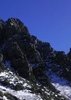
The fire has apparently gone through the main climbing area (AzDailySun) . Sad since it was such a beautiful area and great climbing. It will take some time to determine what is and is not climbable. I imagine that Deidre who published the guide and did much of the building must be heartbroken.
contribute to this member driven resource
ie: RS > Save/Share after hikes Route Scout GPS Topo Mapper on the App Store Route Scout GPS Topo Mapper on Google Play
User avatar
trekkin_gecko
Guides: 10 | Official Routes: 47
Triplogs Last: 4 d | RS: 254
Water Reports 1Y: 0 | Last: 481 d
Joined: Nov 17 2008 4:30 pm
City, State: phoenix, az

Re: Canyon Fire (NE of Blue Ridge Reservoir near Hwy 87)

Post by trekkin_gecko »

hazhole
contribute to this member driven resource
ie: RS > Save/Share after hikes Route Scout GPS Topo Mapper on the App Store Route Scout GPS Topo Mapper on Google Play
User avatar
chumley
Guides: 94 | Official Routes: 241
Triplogs Last: 6 d | RS: 65
Water Reports 1Y: 78 | Last: 8 d
Joined: Sep 18 2002 8:59 am
City, State: Tempe, AZ

Re: Canyon Fire (NE of Blue Ridge Reservoir near Hwy 87)

Post by chumley »

Update on the Fire:
Started: June 29, 2012
Cause: Lightning
Acres: 7500
Containment: 75%
Resources Committed: 3 Engines, 1 Helicopter is available, if needed.
Todays Strategy: Engine crews will concentrate along Highway 87, making sure there are no
hot spots, and extinguishing if there are. One engine will be patrolling on the west side of the
fire checking for hot spots and possible flare ups.
Comments: The fire looks real good; fire personnel did a lot of hard work. The fire
transitioned from a Type 3 incident to a Type 4 incident this morning. The fire received some
precipitation yesterday, and hand crews, dozer, and misc. overhead were demobilized
yesterday afternoon back to their home units. Little Bly Pit is now open; we thank you for your
patience while we used it as a helispot. The Rock Climbing area will remain CLOSED through the
weekend.
We have people down in Jack’s Canyon looking for any hazard trees; lose rocks, and
other possible hazards that need to be dealt with.
Roads leading into the fire on the west side
of Highway 87 will remain closed through the weekend.
Final Map:
Attachments
Canyon Fire Last Map 07042012.pdf
(785.4 KiB) Downloaded 128 times
I'm not sure what my spirit animal is, but I'm confident it has rabies.
contribute to this member driven resource
ie: RS > Save/Share after hikes Route Scout GPS Topo Mapper on the App Store Route Scout GPS Topo Mapper on Google Play
User avatar
azbackpackr
Guides: 27 | Official Routes: 23
Triplogs Last: 78 d | RS: 0
Water Reports 1Y: 0 | Last: 771 d
Joined: Jan 21 2006 6:46 am
City, State: Eagar AZ

Re: Canyon Fire (NE of Blue Ridge Reservoir near Hwy 87)

Post by azbackpackr »

Yeah, I guess they need to lose some rocks in Jack's Canyon...

:D
There is a point of no return unremarked at the time in most lives. Graham Greene The Comedians
A clean house is a sign of a misspent life.
contribute to this member driven resource
ie: RS > Save/Share after hikes Route Scout GPS Topo Mapper on the App Store Route Scout GPS Topo Mapper on Google Play
User avatar
Espi
Triplogs Last: 3,302 d | RS: 0
Water Reports 1Y: 0 | Last: 4,673 d
Joined: Nov 15 2011 9:06 pm
City, State: Tempe, AZ

Re: Canyon Fire (NE of Blue Ridge Reservoir near Hwy 87)

Post by Espi »

that stinks to hear about the climbing area. I have spent alot off weekends climbing up there.
contribute to this member driven resource
ie: RS > Save/Share after hikes Route Scout GPS Topo Mapper on the App Store Route Scout GPS Topo Mapper on Google Play
User avatar
chumley
Guides: 94 | Official Routes: 241
Triplogs Last: 6 d | RS: 65
Water Reports 1Y: 78 | Last: 8 d
Joined: Sep 18 2002 8:59 am
City, State: Tempe, AZ

Re: Canyon Fire (NE of Blue Ridge Reservoir near Hwy 87)

Post by chumley »

The Jack's Canyon climbing area has reopened. The fire is contained, but they are still allowing it to burn in the interior.
I'm not sure what my spirit animal is, but I'm confident it has rabies.
contribute to this member driven resource
ie: RS > Save/Share after hikes Route Scout GPS Topo Mapper on the App Store Route Scout GPS Topo Mapper on Google Play
Post Reply

Return to “Fire & Area Closures”