| | -
-
-
-
-
| 1 label | 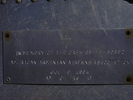 |
|
|
|
| | |
|
| Hiking | 6.00 Miles |
1,680 AEG |
| | Hiking | 6.00 Miles | 6 Hrs 30 Mns | | 0.92 mph |
| 1,680 ft AEG | | | | |
|
|
| |
| Linked |
|
none
[ show ]
| no linked trail guides |
| Partners |
|
none
[ show ]
| no partners | | I originally heard about the crash site in a bar here in Flag. After doing some research, I found out that there is a virtual geocache at the site. I was able to download coordinates to the center of the debris field. Thanks to having accurate coordinates, we wer able to locate the point to leave the Humphrey's Peak trail for the 4/10th mile scramble to the crash site. This spur off of the trail to the peak around 11,000' and crosses steep slopes and scree for about 4/10ths of a mile. Being early November, it was also marked by snow and ice that increased the challenge demonstratively. While there were some small cairns in place marking the path, I chose to follow my GPS and concentrate on avoiding the icy path.
Upon reaching the crash site, one is presented with a scene of total devastation. Debris is scattered for about a quarter of a mile upslope and downslope from the impact point and I surmised by the distribution of the parts of the plane (IE wings, stabilizers, engines, etc,...) that the pilot had seen the mountain just moments before impact and had banked the plane hard to the right and attempted to gain elevation. He would have had a long way to go, as the peak of the mountain (Humphery's Peak) is over a thousand feet above.
It amazed me how much of the plane was still intact after over sixty years of exposure to sun, wind, and ice. I found cockpit controls and dials with numbers intact. The largest section is the starboard wing with the army star insignia still visible. We were able to locate most of the including all four engines, both wings, the tail section, much of the bulk head, and even the plane's radio equipment. The plane was either not armed or the ordinance had been removed after the crash as we found no brass or gun parts. As it was about halfway through its trip, the gas tanks had plenty of fuel. As a result, melted aluminum covers much of the exposed rock near where that portion of the aircraft impacted.
Overall it was a stunning location for such a sobering scene. We spent about an hour sorting through the wreckage, taking pictures, and just standing around in awe. It wasn't easy to find the crash site and it definitley wasn't easy getting back to the trail again. Overall it took us about six hours to get up there and back, but it was worth every step. |
| _____________________
| | |
|
|
|
|
|
| |
 Route Editor


