| | -
| 1 label | 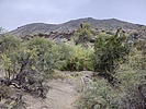 |
|
|
-
-
-
-
| 2 labels | 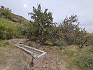 |
|
5 |
-
| 1 label |  |
|
|
|
| | Rondo Spring out and Back, AZ | | | |
|
|
Rondo Spring out and Back, AZ
| | |
|
| Hiking | 4.20 Miles |
1,092 AEG |
| | Hiking | 4.20 Miles | 4 Hrs 30 Mns | | 1.20 mph |
| 1,092 ft AEG | 1 Hour Break | | | |
|
|
| |
| Partners |
|
none
[ show ]
| no partners | | | The trail from New River is still surprisingly easy to follow despite so many invasive weeds, although it is hard to distinguish from cattle trails at some points. There were lots of cattle for the first couple miles. About halfway through the hike is a barbed wire gate between the state trust land and Tonto that is so bent over that we couldn't open it, so we just climbed over/under it. Sadly, at the spring itself the cottonwood(?) tree you can see in others' photos has died--seemingly in the last few years--likely smothered by the invasive arundo donax cane that has taken over the wettest part of the spring. I'm surprised such a plant even got up there, I'm guessing an animal or person from Cave Creek dragged a seed up. The grill is almost covered by the canes, and there's a pile of the stuff like somebody tried cutting it back. Thankfully all the junipers still seem fine, there's even some young ones growing. The hand pump is still broken and the troughs were dry, the only sign of water was damp ground. We hung out around the spring for about an hour just enjoying the scenery before hiking back down. Even with the break we were out less than five hours. It was an amazing day with perfect clouds, temperature and humidity. |
 |
Rondo Spring |
Dry |
Dry |
| | | No puddles, the troughs were empty and the pump is still broken. | | | |
|
|
|
|
|
| |
 Route Editor


