| |
| Vista Grande-Eagle Ridge tails out and back, CA | | -
-
-
-
-
-
-
-
| |  |
|
1 |
-
|
| | Vista Grande-Eagle Ridge tails out and back, CA | | | |
|
|
Vista Grande-Eagle Ridge tails out and back, CA
| | |
|
| Hiking | 6.11 Miles |
1,538 AEG |
| | Hiking | 6.11 Miles | 1 Hour 41 Mns | | 4.47 mph |
| 1,538 ft AEG | 19 Mns Break | 13 LBS Pack | | |
|
|
| |
| Linked |
|
none
[ show ]
| no linked trail guides |
| Partners |
|
none
[ show ]
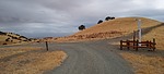
| no partners | | | These trails are at the north end of the Los Vaqueros Reservoir. I started at the John Muir Interpretive Centers upper parking lot. It starts at the Interpretive trailhead then goes down onto a paved road then after 1/4th mi up, a sharp right switchback onto the Los Vaqueros trail (dirt rd) which soon merges into the Vista Grande trail. The first mile is very steep with over 900' AEG then it's easier undulations to the 2 mile mark which has an emergency phone and a Gas Pipeline Sub-Station. Go left onto Eagle View Trail and soon thru a Gate/cattle guard. I only went 3 miles out and back. Great workout, great views! |
| | |
|
|
|
|
|
| |
 Route Editor


