| |
 | Black Mountain 7772, CA | | -
-
-
-
| 1 label | 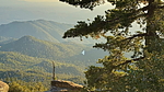 |
|
|
-
| |  |
|
1 |
-
| 2 labels | 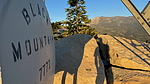 |
|
|
-
| 3 labels | 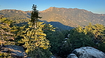 |
|
|
-
| 1 label | 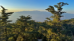 |
|
|
-
| 2 labels | 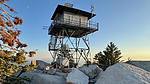 |
|
|
-
-
| |  |
|
4 |
-
-
| 1 label | 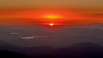 |
|
1 |
|
| | |
|
| Hiking | 1.62 Miles |
404 AEG |
| | Hiking | 1.62 Miles | 48 Mns | | 2.31 mph |
| 404 ft AEG | 6 Mns Break | | | |
|
|
| |
| Partners |
|
none
[ show ]
| no partners | | This seemed like a nice little sunset happy hour walk. It starts from the Boulder Basin Campground, which is heavily populated by climbers due to the many geologic options in the surrounding terrain.
I ascended via the closed 2-track access road which leads to a fire tower that I wasn't really sure existed. Maps show it to be located well off the summit in a location that doesn't make sense to me, and showed no signs of current or previous existence. It is, in fact, on the mountain summit as is typical.
Nice views across to Fuller Ridge, the Sanjay highpoint, north to Gorgonio, and west to the Pacific.
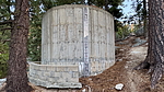
On the return, I decided to follow an unmarked route that is shown on some basemaps. The upper portion was steep with a routefinding hiccup or two, before reaching an old water tank that supplies the campground from the nearby Cinco Poses Spring. From the tank downhill the route followed the old 2-track that provided access to the tank in a long bygone time.
Along the way, the route intersected the Black Mountain Trail 2E35 which heads down from this point connecting to SR 243 about 2300 feet lower. That might be a nice track in cooler weather.
This one was ideal to keep camp boredom from setting in for those like me who can't sit still for more than 15 minutes. |
| _____________________
| I'm not sure what my spirit animal is, but I'm confident it has rabies. |
| | |
|
|
|
|
|
| |
 Route Editor


