| | -
-
| 1 label | 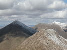 |
|
|
-
-
| |  |
|
1 |
-
|
| | |
|
| Hiking | 11.00 Miles |
2,250 AEG |
| | Hiking | 11.00 Miles | 4 Hrs 45 Mns | | 2.32 mph |
| 2,250 ft AEG | | | | |
|
|
| |
| Partners |
|
none
[ show ]
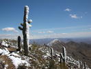
| no partners | | With the rain all day Saturday and waking up to snow covered peaks, I almost thought I was back in Oregon if it wasn't for the lack of trees and all the cactus. I left the house planning on hiking peak 2429 in Phoenix, but when I got towards US60 and saw the Supes covered in snow I headed east instead. Got many great pictures of the snow covered peaks, kept driving towards LDSP, then west on Lost Dutchman, to north on Usery Pass. Flatiron would have been a crazy hike with all the snow up the steep ravines and Usery pass looked too bland without any snow. I headed NE on Bush highway getting more pictures of Four Peaks and the Mazatzals covered in snow. Got to the Beeline and was forced to go south due to snow closing the way up to Payson. Saw the snow covered McDowells and decided to hike this trail since I've researched it a bit in the past and had the rough directions to the trail.
The directions said to follow Golden Eagle Blvd until it ended and goto the trailhead. But all the construction thru me off and there's a future gated community being build at the end of Golden Eagle. I ended up parking in Edgewater Ct just to the south and headed towards an old jeep road I saw in the distance. The jeep road ended and continued as a trail that eventually ended up on top of Peak 3702, the one with an American flag on top. Most of this peak was covered in snow, as were all the other McDowell peaks above 3000 feet. I hiked halfway back down this peak and headed towards Thompson on what I thought was a trail. I was half bushwacking/half following an old nature trail all the way to the service road to Thompson, which is actually quite tough to do considering all the snow on the northside of these peaks. I was so far off track that I didn't hit the road until the part where the concrete starts and from here on was probably the steepest part. Great views on top and much easier hiking out now that I found the actual trail. A strategically placed family hiking the trail was able to tell me to turn right on the Dixie Mine trail to get back to Golden Eagle Blvd where I parked. Thanks guys.
The first problem I had was that I packed for a quick 2.5 mile hike and ended up going to a 10.2 mile trail. The second problem was that I started on the wrong trail and added at least another mile in the snow to what should have been an easy hike on an old jeep road. The third problem was all the bushwacking in the snow from Peak 3702 to Thompson peak completely soaked my socks and shoes. But despite all these minor setbacks I still had an enjoyable time. Live and learn I guess.  |
| _____________________
| Yea, canyoneering is an extreme sport... EXTREMELY dramatic!!! =p |
| | |
|
|
|
|
|
| |
 Route Editor


