|
| | | |
| |
|
| Hiking | 4.97 Miles |
1,497 AEG |
| | Hiking | 4.97 Miles | 4 Hrs 3 Mns | | 1.44 mph |
| 1,497 ft AEG | 36 Mns Break | | | |
|
|
| |
| Linked |
|
none
[ show ]
| no linked trail guides |
| Partners |
|
none
[ show ]
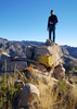
| no partners | | This was the third of 3 hikes that I did in the Tucson area this weekend. This one has some legitimate class 3 climbs, so there was more to the hike than I envisioned.
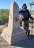
I started and ended the hike at the Sarasota TH. I ascended from the NW, and descended along a ridgeline to the east before dropping down to the north to get back on a trail.
Once you leave the trail and start climbing, route finding can be a challenge. There is no social trail, next to no cairns, and no real obvious way to go. I had some GPX tracks that I mostly followed, but in some places I took a path up that looked good. There were several class 3 climbs, but handholds/footholds were good, the rock was good, and there was minimal exposure.
It was a fun climb actually -- I had to stay focused on what I was doing. I was going slow, but the time went by fast. Before I knew it I was near the summit -- the last few hundred feet to the summit were an easy class 1 walk.
Before the hike, I figured that I would just go back the way that I came. However, I didn't really want to downclimb some of the upclimbs that I had done, so I decided to follow the ridgeline to the east and head down from there. It was tempting to leave the ridgeline shortly after the summit and drop down to the north; while that would shorten the descent, it seemed like you might get cliffed out. Thus, I kept going eastward, following a social trail much of the way. Eventually I got to a point where it was fairly easy to drop down to the desert floor; once on the desert floor it was a short walk back to a trail.
If I was to do the hike again I think that I would use the same route that I used this time -- it worked pretty well I thought.
This was a fun and interesting hike, but those not comfortable with this type of rock climbing should pick another hike. |
| _____________________
| Civilization is a nice place to visit but I wouldn't want to live there |
| | |
|
|
|
 Route Editor