|
| | | |
| |
|
| Backpack | 20.80 Miles |
|
| | Backpack | 20.80 Miles | 3 Days | | |
| | 51 LBS Pack | | |
|
|
| |
| Partners |
|
none
[ show ]
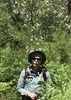
| no partners | | I had wanted to hike the Brush Corral Trail and I was due to go on a short backpacking trip so it seemed logical to kill two birds with one trip. I decided to do this trip last minute but was able to get my gear together and talk one of my coworkers into giving me a ride after work to the Soldier Trail trail-head near mile post one on the Mount Lemmon Highway.
I got started just before 10 AM on the Soldier Trail. It was a nice, cool, morning but the trail climbs quickly and it wasn't long before I was peeling off layers. Several day hikers passed me on their way back down.
I initially thought to stop at the Gordon Hirabayashi Campground to eat lunch, but continued on through and stopped a short distance up the hill along the Bug Springs Trail to enjoy the view. After lunch I continued up the Bug Springs Trial, which also climbs and climbs, and began to hit ever increasing snow along the trail. Most of the snow on the trail was easy walking and didn't impede my progress until I reached the section that turns down into Bear Canyon. This section had seen a lot of foot traffic since the last snow and had been used as a sledding ramp. This resulted in a path that had been compacted to a sheet of ice in many places. Most of the time I could walk along the edges or go around, but in one spot all I could do was sit down and enjoy the ride, pack and all.
I camped the first night in a few inches of snow just a short distance up the Green Mountain Trail in Bear canyon. The wind blew most of the night and I discovered that my Thermarest had a pinhole. I made this discovery at about 4 AM when I awoke cold on the surface touching the ground. As it turned out 4 AM is a good time to visit a tree and re-inflate your mattress.
In the morning there was plenty of running water in Bear Creek to filter some for the day and head up the Green Mountain Trail to Bear Saddle for and early lunch break (I seem to take several). After which I continued on the Green Mountain Trail and onto the more northerly aspects of the mountain. This area had not been travelled by anyone since the snow on December 31st and had a very pristine look to it. Travelling through this unbroken snow was relatively easy at this point.
I turned onto the Shortcut Trail and headed down to the junction with the Brush Corral Trail. I knew from other people's previous post that the brush Corral Trail was less used and in places would be difficult to follow. The first mile or so wasn't bad and was only slightly overgrown. The animals seemed to be getting more use out of the trail than the hikers. Deer and cat tracks followed the trail for long distances. The ridge that the trail follows drops off sharply and after this the trail gets more difficult to follow. On the way downhill I didn't pay much attention to the map and just tried to follow what looked like the path of least resistance. I had originally intended to camp near Brush Corral, but as the sun was getting low I found myself somewhat short of that and was satisfied when I found a suitable spot just east of the Evans Mountain Trail junction.
The wind had again begun to blow and I chose a spot out of the wind to bed down for the night. The spot had a small fire ring and there was an abundance of easy fire wood so a small fire seemed to be in my future. Just after setting up camp and starting the fire the wind shifted for the night and my once sheltered spot was no longer sheltered. So, out went the fire. I sat and read for awhile but the wind put an end to that as well. The temperature was in the 40's but with the wind chill it made it uncomfortable to do anything without gloves, and I can't turn pages to save my life with gloves on. So, plan B. I climbed into my sleeping bag and watched the sky, which fortunately is a great pastime. Fortunately the wind stopped about 9 PM and the rest of the night was really nice.
During the night an owl and a cow seemed to be calling back and forth. Owl would hoot, cow would moo, owl would hoot...........
As I made breakfast the next morning, and packed up, there were several deer and cattle grazing the nearby hillsides, which can make it really hard to get anything done. I just wanted to sit and glass them with binoculars. Once packed, I headed back the way I came up the ridge. Beuhman Creek had a good flow at the trail crossing and I was again able to filter water for the day. Going back up I paid more attention to the map and was able to remain on the old trail much more than I had on the way down. A couple of areas that I was dreading actually passed without much frustration by virtue of being on the trail. The trail in these areas were frequently covered by waist high Manzanita, but that beat side sloping with a heavy pack.
Although steep, I made decent progress and arrived at the trail junction with the Shortcut Trail and had lunch. I contacted my wife and confirmed that she would pick me up at the Upper Green Mountain trailhead at 5 PM. This gave me 3 hours to travel just over 2 miles. I knew I would run into heavier snow heading up to the trailhead as this area is steep and sheltered from the sun. For the first mile the trail was open and passed quickly. In the last drainage where the trail switchbacks up to the Green Mountain junction the snow got deeper and had varying levels of ice. The last 3/4 mile took me nearly 2 hours to cover and I was both tired and wet when I emerged at the top.
I arrived at the trailhead about 10 minutes late and headed home for some Chinese food and a hot shower. Another trail checked off the list. |
| _____________________
| | |
|
|
|
 Route Editor