|
| | | |
| |
|
| Hiking | 7.63 Miles |
1,253 AEG |
| | Hiking | 7.63 Miles | 6 Hrs 10 Mns | | 1.91 mph |
| 1,253 ft AEG | 2 Hrs 10 Mns Break | | | |
|
|
| |
| Partners |
|
[ show ]
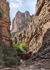
| partners | | A good friend and former co-worker decided to move back east where he grew up, so we organized a farewell hike before he leaves Arizona in a few days. I hadn't seen him or hiked with him since early March last year, right before the pandemic hit. With this being a weekday and since Boynton is always flooded with tourists on the weekends, I figured this could be a good chance to try to reach the large "cracked wall" cliff dwelling that I located but ran out of time to visit in late July.
Finding a good route up to the ruin last time made this a more efficient hike, and we headed directly to the side canyon I used last time to get up on top of the cliffs where it's located. The pools that were in that side canyon six weeks ago had dried up, but we still had to dodge poison ivy along the way. Once on top, we made our way through manzanita to the base of a rock formation with a small ruin where I turned around because of approaching last time. We took a break there while we planned out a route over to the cave, which would require navigating some thick brush and then some climbing. It looked like it could be quite a vertical scramble just to reach the ledge where we'd have to climb up into the cave. Based on descriptions I'd read about the difficulty, I had doubts that we'd actually be able to get inside, but we had to try.
As we got going, the brush was worse than expected. I was clipping the worst of it out of the way, and we all stomped through dead branches and picked up a lot of cuts and scratches. The brush opened up a little as we reached the bottom of the slope leading up to the cave. I stayed to the left and picked up a faint trail that avoided most of the foliage on the climb...one of my friends followed me; the other tried a different route to the right. I was pleasantly surprised by the climb up the slope--it wasn't as steep as it appeared from across the canyon, there were solid footholds in the steepest parts, and we reached the ledge below the cave without too much trouble.
To the left and below the large cave was a smaller one that had remains of two walls, some wooden beams, a bunch of corn cobs and pottery sherds, and part of a metate. That cave had some interesting erosion on the ceiling and extended far back into the wall but became too narrow to get back very far. From below the large cliff dwelling, we could see some Purtymun inscriptions on the right side of the cave...these were from Floyd and Swelle (?) Purtymun, and at least one other name that I couldn't make out--Stanley (something). The dates were a little hard to read, but one said 1926 and the other looked like 1917. The Purtymuns really did a lot of exploring (and vandalizing) in their time--this is the third canyon where I've seen their names inscribed at various ruins sites. And it must have been a big family--I've found different first names at every site.
We worked on climbing into the cave and tried various routes on the left, right, and center. Each area had surprisingly good hand/footholds partway up the wall, but it consistently felt like we were one final, solid hold away from being able to pull ourselves up any of the routes. I was about to give up, but my friend was determined to get at least one of us up there. He ended up getting down on all fours, and while I stood on his back, my other friend used his hands to give me an extra foothold as I tried again. I was finally able to get a solid grip on a large boulder and pulled myself up and in.
The ruin was very impressive--the front wall still has a lot of mortar intact but has "foundation problems" and has cracked from settling/sliding forward in the cave. That wall has two vents/lookout holes in it. A middle wall is fairly deteriorated, but there's a back room with an extremely well preserved wall and doorway, with a wood frame on the top. The glass jar with the register was located on the right side of the cave and had four or five loose pages in it. It was hard to read the names because the pencil in there wasn't great, but the most recent entries I found were from 8/29 and 9/2 this year. I had my friend throw a pen up to me, and I added our three names and wrote a farewell message to my friend who's moving.
Getting down wasn't as bad as expected...the only unsettling part was putting all my weight on the same boulder I'd used to pull myself up. The whole right side of the dwelling looks like it could slide out the front of the cave, and that boulder is heavy and sturdy, but it's sitting at an uncomfortable slant. In the position I was in, I didn't really have any choice but to trust it with my weight. Thankfully it held, and using my friends' hands and back again, I made it down. It was some great teamwork--it took three of us, but we got someone up and down safely, something I had serious doubts we'd be able to do today  . .
We went over to the small cave and relaxed and ate lunch in the shade there before we started the descent. We found a less brushy route back to the smaller ruin, which saved us some time and scratches, then we headed back down the chute to the side canyon. On the hike out, my friend noticed a distant rock and thought he saw another ruin wall. I zoomed in and took a picture but didn't see anything of interest, but looking at the image later on a bigger screen, it turned out he was right--there was a small ruin wall halfway up a cliff...another one to explore .
When we got back to the parking lot, someone named Kristen had left a note under our windshield wiper with her phone number and email address. It said that she was the person we'd talked to earlier with the dog, and she was wondering if we'd be her tour guide for a hike sometime. That was very strange, because we hadn't talked to anyone with a dog all day--or really anyone at all, for that matter--so it was probably a case of mistaken vehicle identity...
It was a great day, but a bittersweet farewell for my friend. I was happy we got to hike one last time before he moves away, and it was a fitting goodbye to sign our names in the register after I literally stood on his back to get up there. I'd been looking for and then trying to get into that cliff dwelling for almost 10 months, and it's one of the best I've seen in Sedona. Hopefully my friend will be back to visit often. |
| | |
|
|
|
 Route Editor