|
| | | |
| |
|
| Hiking | 4.50 Miles |
100 AEG |
| | Hiking | 4.50 Miles | 3 Hrs | | 1.50 mph |
| 100 ft AEG | | | | |
|
|
| |
| Linked |
|
none
[ show ]
| no linked trail guides |
| Partners |
|
[ show ]
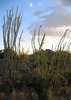
| partners | | This hike started out as in impromptu fishing trip. We grabbed the rods and a few bottles of water and headed out. The drive to the lake from Tucson was beautiful.
We got to the lake and set off on the trail in the counterclockwise direction mentioned in the description. Initially we were just looking for somewhere to cast with a fewer weeds, but as so often happens, we just kept going when it might have been a little smarter to turn around. When you look at the lake from dock, it looks deceptively small, so we told ourselves "the lake can't be that big, so lets just keep going." There are many inlets that you just can't see from the vantage point of the dock. The last one that you encounter before the dam is the largest, and in my opinion, the nicest part of the lake. In this area the trail starts to climb a little and you find yourself looking down on the lake in spots. There is a little island in the middle and we found a nice secluded picnic area that is presumably reached from some forest service road. Every time we found a likely spot, we would stop and try out luck at fishing. I caught a small bass (which we released) and Rob caught some really spectacular weeds. By the time we hit the dam, the sun was starting to set and we decided to pick up the pace, finishing the circuit just after dark.
There was an area right after the dam, where the trail starts to move away from the lake and another trail, that looks like a social trail, stays close to the shoreline. We opted for the social trail, which resulted in a little bit of confusion when we hit the spillway just after the dam. We eventually figured out that you have to climb up the hill and around the back of the area, where the actual trial would have spit us out had we just stayed on it. |
| _____________________
| | |
|
|
|
 Route Editor