 Route Editor

| Guide | ♦ | 21 Triplogs | 0 Topics |
details | drive | permit | forecast | route |
stats |
photos | triplogs | topics | location |
| 173 | 21 | 0 |
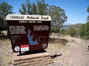
Hiking in wine country. Don't stumble by chumley   In 1966, the Arizona Game and Fish Department completed the earthen dam at the confluence of Parker Canyon, Collins Canyon, and Merritt Canyon in the beautiful rolling Canelo Hills southeast of Sonoita and six miles north of the Mexico border. The result is the largest lake on the Coronado National Forest. The Forest Service constructed and maintains the recreational facilities at the lake, including two campgrounds and a small general store. In 1966, the Arizona Game and Fish Department completed the earthen dam at the confluence of Parker Canyon, Collins Canyon, and Merritt Canyon in the beautiful rolling Canelo Hills southeast of Sonoita and six miles north of the Mexico border. The result is the largest lake on the Coronado National Forest. The Forest Service constructed and maintains the recreational facilities at the lake, including two campgrounds and a small general store.The 130-acre lake features a spillway elevation of 5387 feet, creating a nice escape from the heat of the desert floor, with temperatures about 10-15 degrees cooler than Tucson.
But first to the hike! The trail begins at the fully developed boat ramp area, featuring three fishing docks, the general store, restrooms, and a few huge cottonwood trees. Head north from the store in a counterclockwise direction around the lake and the trail begins as a paved sidewalk with occasional benches for resting and enjoying the view. You are likely to encounter numerous anglers here as this is the primary walking route between the docks and the campground. From the start of the hike, the lake looks deceptively small, as you can see less than half of it from this vantage point. But the size of the lake and the length of the hike will also surprise as numerous inlets add to the coastline. Before passing the first inlet, the pavement ends and the trail becomes a very well maintained and comfortable packed dirt/gravel surface. The trail stays only a few feet from the shore and continues back toward the west before turning north with the campground on the hill above at about the half-mile marker. Along the entire east side of the lake, numerous trails lead from the various camping areas and nearby road access, but there is no problem keeping with the shore trail as it is well-traveled and easily followed. After 3/4 mile, the hike enters another inlet featuring another small fishing dock. A side trail leads from here to Rock Bluff Campground (a group site). From this inlet, there is no view of the main lake but requires you to continue about half a mile to get back out on a point that features nice views to the south, the dam, and the campground on the hill. It's another 3/4 mile to the end of the next inlet, one of two of which make the north end of the lake. Here you will find a sign that indicates the boat dock is 2 1/4 miles behind you. This end of the lake is much more wooded, with shady pines and large cottonwoods. The trail finds its way among tall grasses but is generally still easy to follow. At this point, I was wondering when the trail would make the final turn back toward the south, but there was one more inlet and a short northern section before turning making the turn back down the west side of the lake. The lake was full when I was here, but water levels vary each year. Even while full, the water level is pretty shallow at the north end of the lake, and there are sections of water grasses. I encountered what must have been hundreds of frogs in some kind of mating ritual. The noise they created was incredible. It sounded like a group of people on quads, or maybe a few chainsaws in full operation. The sound could be heard from a mile away! The first half mile heading back continues to be in a more wooded area, with numerous small inlets to hike around before becoming a much straighter course toward the dam. A small inlet followed by a small peninsula at about 3-1/4 miles obscures the dam until you are virtually upon it. After crossing the dam, the trail heads away from the lake to the bottom of the spillway. Cross the spillway and head back up and over the hill to the lakeshore. A quarter-mile past the dam, the trail turns west and heads back the final mile to the docks. There is, of course, one final small inlet just to make the hike be just that much longer than you thought it was! Back at the dock, grab some food at the store, or relax on a bench under the shady cottonwoods. From here, hop in the car and head up to Elgin for the wine tasting! (The Arizona Trail connects at the lake, so if you're backpacking the trail, this makes a nice respite where you can put your pack down for a couple of hours and go for what is an easy stroll relative to that!) A word of caution: While Parker Canyon Lake is a developed recreation area that is usually well visited, there are times of the year and days of the week when you might find some solitude. Since the lake is only 6 miles from Mexico, the area is frequented by smugglers and immigrants (as indicated by a sign when entering the recreation area). There's a handful of homes on some private property in the hills a mile or two above the lake, and in a sobering display for this secluded mountain community, every cabin I saw was adorned with security bars on their windows and doors, like you might see in South Phoenix. So, keep that in mind if you head out here by yourself or during times when you might be alone. Check out the Official Route and Triplogs. Leave No Trace and +Add a Triplog after your hike to support this local community. | |||||||||||||||||||||||||||||||||||||||||||||||||||||||||||||||||||||||||||||||||||||


