username
X
password
register
for free!
help
ArticlesGuidesRoutes
 
Photosets
 
 Comments
triplogs   photosets   labels comments more
Sunset Arch - 3 members in 12 triplogs have rated this an average 4 ( 1 to 5 best )
12 triplogs
login for filter options
Mar 02 2023
avatar

 Guides 8
 Routes 70
 Photos 3,208
 Triplogs 273

59 male
 Joined Oct 07 2017
 Chandler, AZ
Sunset ArchPhoenix, AZ
Phoenix, AZ
Hiking avatar Mar 02 2023
YoderTriplogs 273
Hiking1.00 Miles 420 AEG
Hiking1.00 Miles
420 ft AEG10 LBS Pack
 
Linked   none no linked trail guides
Partners none no partners
A quick run out to the Sups to get some snow photos after the storm.
_____________________
J. Yoder
 
Feb 12 2022
avatar

 Routes 2
 Photos 6
 Triplogs 9

45 male
 Joined Mar 18 2012
 Mesa, AZ
Sunset ArchPhoenix, AZ
Phoenix, AZ
Hiking avatar Feb 12 2022
mistabenTriplogs 9
Hiking1.00 Miles 420 AEG
Hiking1.00 Miles   3 Hrs      0.40 mph
420 ft AEG      30 Mns Break5 LBS Pack
 no routesno photosets
1st trip
Linked   none no linked trail guides
Partners none no partners
I made a goal to get my little twin boys hiking more often, and this was a great trail to start with. My wife and one daughter came along as well. It was a little more than the little guys were ready for, so we took our time. That mostly consisted of me either holding two toddlers' hands or holding one boy and the hand of the other. We all had a terrific time.

We found the trailhead shoulder parking area unoccupied and hit the trail. Temperatures remained in the 70s our entire time out.

The very brief climb on the old access road brought us to the old ridge road following the power lines. The first low cairn is about 75 feet to the right when you reach the ridge, but it had been disassembled, so we rebuilt it on our way out. We found 9mm brass on that ridge road and target and skeet shooting debris along the descent from there to the first stream bed.

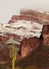
From there, the hard of work of Yoder and his wife really starts to shine, with rocks outlining the trail and big, sturdy, beautiful cairns. The trail is very fresh through pristine desert. It provides several opportunities for hikers new to the Sonoran desert to practice giving a wide berth to barrel cactus, saguaros, cholla, and ocotillo. The soil is loose and my toddlers slipped about a hundred times each, After the relatively flat stretch among the saguaros, it was a quick descent to the second stream bed and then a bit of a climb. The steps notched into the slope were super helpful. My boys developed a basic sense of which rocks were secure in the trail and which would not support any weight.

We made it right up to the boulder near the arch and had a snack in the afternoon shade, enjoying the outstanding views. We could see the roof of our vehicle parked along the road half a mile away. After a peek around the back of the butte top to see Weaver's Needle and some extended negotiations over the size of souvenir rocks (pretty big for toddlers) and who would carry them (me), we started our painfully slow way down the trail. The trail is fine, but the toddlers were weary and nervous. :lol:

Among the saguaros on the way down, one of them said to me "I don't like hiking." "You didn't like this hike?" "I didn't." "You didn't. That's alright, there will other hikes you like better."

I expect that after a lot more use, the soil will be compacted more and firm footing will be much better for little ones. In the meantime, for any party with a taller minimum height than ours, this is an awesome trail that quickly gets you into and above the desert.

Amazing job on the trail, Yoder!
wildflower observationwildflower observationwildflower observationwildflower observationwildflower observation
Wildflowers Observation Isolated
Pale purple wildflowers on simple green stems with a few other grass-like leaves were growing right in the trail, mostly in the Saguaro stretch between stream beds. Most were under 7 inches tall, but some that grew off the trail were up to a foot with a deeper purple petal color.

Three or four Mexican Gold Poppies warmly greeted us as we climbed after crossing the 2nd stream bed.
_____________________
 
Jan 22 2022
avatar

 Routes 167
 Photos 973
 Triplogs 130

male
 Joined Mar 17 2021
 Phoenix, arizona
Sunset Arch Family Hike, AZ 
Sunset Arch Family Hike, AZ
 
 Hiking avatar Jan 22 2022
JackArizonaTriplogs 130
 Hiking1.13 Miles 412 AEG
 Hiking1.13 Miles   1 Hour   33 Mns   0.82 mph
412 ft AEG      10 Mns Break
 
1st trip
Linked   linked  
Partners none no partners
Route Scout Route Recorded  on Route Scout | Pop | Map | Popup | MapDEX
 
Nov 21 2021
avatar

 Guides 8
 Routes 70
 Photos 3,208
 Triplogs 273

59 male
 Joined Oct 07 2017
 Chandler, AZ
Sunset ArchPhoenix, AZ
Phoenix, AZ
Hiking avatar Nov 21 2021
YoderTriplogs 273
Hiking1.00 Miles 550 AEG
Hiking1.00 Miles
550 ft AEG10 LBS Pack
 
Linked   none no linked trail guides
Partners none no partners
Me and the wife just finished the trail today(2021-11-21). Looks like John10s let the cat out of the bag before we completed the final touches. :)

I have emailed Joe & HAZ_hikebot on the process of updating the trail guide including description, and GPS route so expect that to be updated shortly The new trail is well defined with cairns, and some rocks lining the trail in some sections. I will include photos of various sections of the trail so you can get an idea of how it is marked.

The new official trail is almost 0.5 miles one way, so this is a short one, but it's a fantastic location for sunset/sunrise photos.
_____________________
J. Yoder
 
Nov 20 2021
avatar

 Guides 25
 Routes 376
 Photos 5,897
 Triplogs 346

40 male
 Joined Mar 01 2018
 Chandler, AZ
Sunset ArchPhoenix, AZ
Phoenix, AZ
Hiking avatar Nov 20 2021
John10sTriplogs 346
Hiking1.05 Miles 389 AEG
Hiking1.05 Miles      59 Mns   1.29 mph
389 ft AEG      10 Mns Break
 
1st trip
Linked   none no linked trail guides
Partners partners
TboneKathy
Route Scout Route Recorded  on Route Scout | Pop | Map | Popup | MapDEX
After hiking to Music Mountain earlier in the day, we pulled off SR 88 on the drive back from Tortilla Pass Trailhead for a quick hike to Sunset Arch, which seemed appropriate since it was approaching sunset. It's only about half a mile up to the arch, and the trail is well defined and clearly marked with very tall cairns...someone went to a lot of work to balance rocks out there. There are some steep sections of the trail, but given how short it is, it's an easy hike, with ~400 feet of AEG.

The sky had a lot of great color as we hiked up, and we reached the arch at just about the perfect time to snap some pictures as the color began to fade and the city lights came into view. The official route is a lasso loop, but we hiked it as an out-and-back of just over a mile. It got dark quickly, and we finished with our headlamps out...a nice way to end a fun day of hiking in the Superstitions. Sunset Arch is a worthwhile stop for a quick hike if you happen to be driving by on SR 88, especially around sunset :).
 Named place
 Named place [ checklist ]
[ checklist ]  Sunset Arch - Goldfield Mtns
 Meteorology
 Meteorology [ checklist ]
[ checklist ]  Sunset
 
Oct 24 2021
avatar

 Guides 8
 Routes 70
 Photos 3,208
 Triplogs 273

59 male
 Joined Oct 07 2017
 Chandler, AZ
Sunset ArchPhoenix, AZ
Phoenix, AZ
Hiking avatar Oct 24 2021
YoderTriplogs 273
Hiking1.60 Miles 715 AEG
Hiking1.60 Miles      57 Mns   1.68 mph
715 ft AEG   1 Hour   50 Mns Break10 LBS Pack
 
Linked   none no linked trail guides
Partners none no partners
Weather conditions looked pretty good for a decent sunset so we decided to hop on over to check out Sunset Arch. Got there a little early, checked out the top of the Butte. A pretty decent sunset.
 Flora
 Flora [ checklist ]
[ checklist ]  Saguaro
 Named place
 Named place [ checklist ]
[ checklist ]  Sunset Arch - Goldfield Mtns
 Meteorology
 Meteorology [ checklist ]
[ checklist ]  Sunset
_____________________
J. Yoder
 
Jan 13 2021
avatar

 Guides 187
 Routes 989
 Photos 12,068
 Triplogs 864

72 male
 Joined Jun 27 2015
 Tucson, Arizona
Sunset Arch, AZ 
Sunset Arch, AZ
 
Hiking avatar Jan 13 2021
markthurman53Triplogs 864
Hiking1.21 Miles 388 AEG
Hiking1.21 Miles   1 Hour   32 Mns   0.85 mph
388 ft AEG      7 Mns Break
 
Linked   linked  
Partners partners
mamakatt22
On the first day of our three day Apache Junction trip we hiked to Sunset Arch. Of course we had to wait till just before sunset to do this hike. I have done this hike before and was quite impressed by the display the setting sun put on, this trip was no different. We were fortunate enough to have a light overcast sky with a break at the horizon which made the sunset spectacular. We arrived at the arch about 20 minutes before sunset so we waited around for the show to begin. It was spectacular again.

There is no trail to this arch so it is completely a bushwhack. No cairns to guide the way, so just go uphill toward the arch. We headed to the saddle to the north of the arch and the arch is about 200 yards from that. There are great sunset views to the East over the Superstitions from the saddle. Once the sun put on its show we headed back down. You want to be able to get down before it gets dark because the terrain is very rocky and unforgiving. I will be glad when the area gets some moisture because the saguaros are looking a bit thin, very different from when I was here a year or so ago.
_____________________
 
Mar 17 2019
avatar

 Guides 187
 Routes 989
 Photos 12,068
 Triplogs 864

72 male
 Joined Jun 27 2015
 Tucson, Arizona
Sunset Arch, AZ 
Sunset Arch, AZ
 
Hiking avatar Mar 17 2019
markthurman53Triplogs 864
Hiking1.30 Miles 442 AEG
Hiking1.30 Miles   1 Hour   14 Mns   1.70 mph
442 ft AEG      28 Mns Break15 LBS Pack
 
Linked   linked  
Partners none no partners
Did something a little different on this trip to Apache Junction, I left Sunday afternoon instead of getting up at zero dark thirty to arrive in the Superstitions early Monday morning. As a result I had time to get in a short hike before it got dark. This would be a sunset hike and what would be more appropriate than sunset Arch. There is no trail to this arch but the cross country route to the arch is fairly easy. The return trip was a little different from the way in because from above the easiest route is more apparent. Could not get a picture of the sunset through the arch because it was not oriented properly and I was unable to rotate the arch or move the sun. I did play around with the camera on a few saguaros with the sun set (kind of a Rayhuston effect). Great views to the Northeast over Salt River Canyon, Weavers Needle and Superstition Ridge to the Southish.
_____________________
 
Dec 27 2018
avatar

 Guides 2
 Routes 267
 Photos 9,816
 Triplogs 402

62 male
 Joined Dec 02 2014
 Mesa, AZ
Sunset ArchPhoenix, AZ
Phoenix, AZ
Hiking avatar Dec 27 2018
adillingTriplogs 402
Hiking1.40 Miles 550 AEG
Hiking1.40 Miles
550 ft AEG
 
1st trip
Linked   none no linked trail guides
Partners none no partners
I had a few hours free today and decided to visit this neat little arch off Hwy 88. The weather was nice in Gilbert when I left, but there was a nice chilly breeze blowing and lots of cloud cover out when I parked at the turn in the road where this trail starts.

I hike up here once before many moons ago. It's a nice little jaunt with some nice views of the Goldfields, the Superstition Mountain and Weavers Needle on the little saddle to the north of the little peak the arch is on. You get a nice view of Little Four Peaks from the opposite hill as well.

Always a treat to hike during the week and definitely a treat to hike in the Supes.
_____________________
"Jobs fill your pockets, adventures fill your soul."

instagram: @andydilling
 
Dec 06 2012
avatar

 Guides 14
 Routes 71
 Photos 474
 Triplogs 71

male
 Joined Nov 24 2006
 Mesa, AZ
Sunset ArchPhoenix, AZ
Phoenix, AZ
Hiking avatar Dec 06 2012
sventreTriplogs 71
Hiking1.40 Miles 550 AEG
Hiking1.40 Miles
550 ft AEG
 
1st trip
Linked   none no linked trail guides
Partners none no partners
Terrific morning to go an find the Sunset Arch. This little gem is impossible to spot from SR88 despite the fact that you are looking right at it. Poised in a west-southwest direction, it becomes apparent as you take the clockwise route up and over a short string of peaks to the north of that one which houses the arch. Scrambling up and down loose rock was preferable to hacking through the vegetation in the washes. Definitely a hike worth the effort.
_____________________
 
Dec 06 2011
avatar

 Guides 4
 Photos 542
 Triplogs 573

46 male
 Joined Oct 19 2010
 Mesa, AZ
Sunset ArchPhoenix, AZ
Phoenix, AZ
Hiking avatar Dec 06 2011
Charger55Triplogs 573
Hiking1.40 Miles 550 AEG
Hiking1.40 Miles   1 Hour      1.40 mph
550 ft AEG
 no routesno photosets
1st trip
Linked   none no linked trail guides
Partners none no partners
An arch in the Goldfields I haven't seen yet? Thanks for posting this, Mr. AZLOT! This is a short off-trail trip and an easy peak bag if you want to summit the butte. There's a summit cairn covered in bird scat but no register that I could find. Good views down into the First Water TH area.
_____________________
"I've driven across deserts, driven by the irony, that only being shackled to the road could ever I be free"
- Frank Turner "The Road"
 
Nov 26 2011
avatar

 Guides 177
 Routes 249
 Photos 10,213
 Triplogs 2,215

74 male
 Joined Feb 12 2002
 Gold Canyon, AZ
Sunset ArchPhoenix, AZ
Phoenix, AZ
Hiking avatar Nov 26 2011
AZLOT69Triplogs 2,215
Hiking1.50 Miles 659 AEG
Hiking1.50 Miles   2 Hrs      0.75 mph
659 ft AEG
 
1st trip
Linked   none no linked trail guides
Partners none no partners
Cooler weather means bushwhacking and fresh discoveries.
_____________________
It's best for a man to remain silent and be thought a fool, than to open his mouth and remove all doubt.
--Mark Twain
 
average hiking speed 1.21 mph

WARNING! Hiking and outdoor related sports can be dangerous. Be responsible and prepare for the trip. Study the area you are entering and plan accordingly. Dress for the current and unexpected weather changes. Take plenty of water. Never go alone. Make an itinerary with your plan(s), route(s), destination(s) and expected return time. Give your itinerary to trusted family and/or friends.

helpcommentissue

end of page marker