|
| | | |
| |
|
| Canyoneering | 10.00 Miles |
3,200 AEG |
| | Canyoneering | 10.00 Miles | 12 Hrs | | 0.83 mph |
| 3,200 ft AEG | | | | |
|
|
| | Intermediate Canyoneering - Difficult or dangerous; Tech Climb; rope reqd; descent anchor; exit technical; | | B - Up to light current; wading/swimming; possible wet/dry suit | | IV - Long, full day, bivy possible |
| |
| Partners |
|
[ show ]
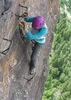
| partners | | So this canyon was on my list for last spring but I didn't quite get to it before summer arrived and I turned my attention to the Mogollon Rim. The temps have dropped again and now I'm playing in the mountains of central AZ again.  The thing about Y Bar is that it's a bit of a haul to get there and an even longer haul to get back... The thing about Y Bar is that it's a bit of a haul to get there and an even longer haul to get back...  From the Barnhardt TH, we headed south on the Y Bar trail past Shake Tree, over Cactus Saddle, and down into Y Bar Basin. The canyon quickly starts out with down climbs and pools and before we knew it we were gearing up at the first drop. It looked down climbable but it was a lil sketchy and we hauled the ropes all the way in here so we might as well use them. From the Barnhardt TH, we headed south on the Y Bar trail past Shake Tree, over Cactus Saddle, and down into Y Bar Basin. The canyon quickly starts out with down climbs and pools and before we knew it we were gearing up at the first drop. It looked down climbable but it was a lil sketchy and we hauled the ropes all the way in here so we might as well use them.  They anchor pulled right out but it was the best option so I rammed some more rocks into the crack, crossed my fingers, and hoped it held. They anchor pulled right out but it was the best option so I rammed some more rocks into the crack, crossed my fingers, and hoped it held.  It really was a decent anchor after some work, but everyone was a lil nervous on it. So we dropped down to Fritzski's secret pools from a decade ago but even though we had shorty wetsuits, no one wanted anything to do with the water. It really was a decent anchor after some work, but everyone was a lil nervous on it. So we dropped down to Fritzski's secret pools from a decade ago but even though we had shorty wetsuits, no one wanted anything to do with the water.  A little cold water won't kill ya! Fearing a mutiny, I setup a dirty cliff rappel off to the side to avoid the two clear inviting pools and instead was dodging agave and loose rocks. A little cold water won't kill ya! Fearing a mutiny, I setup a dirty cliff rappel off to the side to avoid the two clear inviting pools and instead was dodging agave and loose rocks.  We'll have to come back on a warm spring day when it's flowing a bit more and really rock this canyon out! We'll have to come back on a warm spring day when it's flowing a bit more and really rock this canyon out!  Some more down climbs and then the canyon goes thru some scenic slickrock narrows before arriving at the top of a HUGE triple drop. Some more down climbs and then the canyon goes thru some scenic slickrock narrows before arriving at the top of a HUGE triple drop.  The first drop we did a 50ft class 3 downclimb thru a chute on the right side. The next drop was a ~120ft sloped drop with two chutes to choose and of course we had to choose the dry chute... The final drop was a super sweet ~140ft drop next to the falls down into a grotto with a deep pool below. I angled towards the left and got wet up to mid-thigh in the refreshing water but it was funny to watch my buddies do funky maneuvers to prevent themselves from getting wet. This was followed by what looked to be a down climb & swimmer but thankfully we found a class 3/4 sloped wall on the right side to avoid it. Okay, that time I didn't mind avoiding the water. We thoroughly enjoyed that sweet narrows, but I wasn't going to lie to them so I reminded them we had a LOT of hopping rock to get back to our lower shuttle vehicle... The first drop we did a 50ft class 3 downclimb thru a chute on the right side. The next drop was a ~120ft sloped drop with two chutes to choose and of course we had to choose the dry chute... The final drop was a super sweet ~140ft drop next to the falls down into a grotto with a deep pool below. I angled towards the left and got wet up to mid-thigh in the refreshing water but it was funny to watch my buddies do funky maneuvers to prevent themselves from getting wet. This was followed by what looked to be a down climb & swimmer but thankfully we found a class 3/4 sloped wall on the right side to avoid it. Okay, that time I didn't mind avoiding the water. We thoroughly enjoyed that sweet narrows, but I wasn't going to lie to them so I reminded them we had a LOT of hopping rock to get back to our lower shuttle vehicle... ](https://hikearizona.com/dex2/images/smilies/eusa_wall.gif "Brick wall") Dropped the gear, and after much boulder hopping & down climbing & creek avoiding we finally reached the main Bars Creek. On a side note, that lower Y Bar had loads of trash & irrigation tubing left from Marijuana growers. Dropped the gear, and after much boulder hopping & down climbing & creek avoiding we finally reached the main Bars Creek. On a side note, that lower Y Bar had loads of trash & irrigation tubing left from Marijuana growers.  Took a light snack break at the confluence, rechecked the topo on my iPhone to confirm that yep we're in the middle of nowhere, and continued rock hopping down canyon. Hopping along Bars Canyon and about an hour later around sunset, we hit a small narrows section with a couple short drops into pools. Took a light snack break at the confluence, rechecked the topo on my iPhone to confirm that yep we're in the middle of nowhere, and continued rock hopping down canyon. Hopping along Bars Canyon and about an hour later around sunset, we hit a small narrows section with a couple short drops into pools.  Hmm, well we don't have time to play in this today so let's find a way to bypass. After much thrashing on the northside while trying to stay on a faint use trail, we eventually came to the confluence with Shake Tree and took the ridge back down to the now dry creek. The Deer Creek trail comes in just down canyon from there but it was pitch black by now and while following the rocky dry creek by headlamp we probably paralleled the trail a half mile or so before linking up with it. I'm blaming it on the old topo on my phone not showing the trail like the new ones online do. Once on the trail, we picked up the pace and as it left the creek and headed south towards the new TH along the highway. After two hours of hiking in the dark and 12 hours of mucho rock hopping, it was SO nice to be back to a vehicle though we still pick up the other one. Hmm, well we don't have time to play in this today so let's find a way to bypass. After much thrashing on the northside while trying to stay on a faint use trail, we eventually came to the confluence with Shake Tree and took the ridge back down to the now dry creek. The Deer Creek trail comes in just down canyon from there but it was pitch black by now and while following the rocky dry creek by headlamp we probably paralleled the trail a half mile or so before linking up with it. I'm blaming it on the old topo on my phone not showing the trail like the new ones online do. Once on the trail, we picked up the pace and as it left the creek and headed south towards the new TH along the highway. After two hours of hiking in the dark and 12 hours of mucho rock hopping, it was SO nice to be back to a vehicle though we still pick up the other one.  |
| _____________________
| Yea, canyoneering is an extreme sport... EXTREMELY dramatic!!! =p |
| | |
|
|
|
 Route Editor