|
| | | |
| |
|
| Canyoneering | 14.00 Miles |
3,000 AEG |
| | Canyoneering | 14.00 Miles | 14 Hrs | | 1.00 mph |
| 3,000 ft AEG | | | | |
|
|
| | Intermediate Canyoneering - Difficult or dangerous; Tech Climb; rope reqd; descent anchor; exit technical; | | B - Up to light current; wading/swimming; possible wet/dry suit | | Risky - Extraordinary risk factors exist; solid skills/judgement reqd; no beginners | | IV - Long, full day, bivy possible |
| |
| Partners |
|
[ show ]
| partners | | Easily the most amAZing & scenic technical canyon in the Mazzies that I know of!!! 
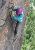
Going in with just beta on the tallest drop, I wasn't expecting much... It was just the next major canyon north of Barnhardt.  That Rock Creek trail isn't the easiest to follow but it's def much better with all the tape & cairns along the way. Once at that first bypassible waterfalls, we geared up, slung the tree, and rapped down that 80ft double drop. Some rock hopping takes you quickly to the next drop of like 30ft. There was no webbing for this drop either so I suspect it was either removed or they found some way to down climb around... This was followed by a fair amount of rock hopping & down climbing thru slick red quartzite & bypassing a few pools before the canyon dropped very quickly. That Rock Creek trail isn't the easiest to follow but it's def much better with all the tape & cairns along the way. Once at that first bypassible waterfalls, we geared up, slung the tree, and rapped down that 80ft double drop. Some rock hopping takes you quickly to the next drop of like 30ft. There was no webbing for this drop either so I suspect it was either removed or they found some way to down climb around... This was followed by a fair amount of rock hopping & down climbing thru slick red quartzite & bypassing a few pools before the canyon dropped very quickly.  Now the rock layer had been at that funky 45* angle but it was VERY pronounced thru this steep technical section. Kinna trippy and sweet to descend the next technical section involving a steep 40ft down climb thru agave & some slick angled down climbing before hitting the next unique cascading falls rappel of about 120ft. We made sure to get back and to the right LUC to avoid sticking the block in the chockstones of that crack alongside that drop. This was quickly followed by a 40ft drop to a flat ledge with some trees where I slung another tree for yet another 40ft drop into a V-shaped hallway. After popping out of the hallway, you get the impression that the rappelling is done but just around the corner is another 50ft drop to a boulder pile. Most of these Mazzie canyons just have a small steep narrows with a handful of narrows, so we got comfortable in thinking the technical stuff was over as we proceeded to navigate thru loads more rock hopping & down climbing along the bubbling creek over greenish grey slickrock. Well a little further down canyon and just around the corner were the canyon starting to narrow up a bit, we run smack-dab into a 180ft steeply cascading waterfall. We can see the end of the canyon in the distance but as the daylight is quickly slipping away it becomes apparent we'll be doing a fair amount of night hiking. Now the rock layer had been at that funky 45* angle but it was VERY pronounced thru this steep technical section. Kinna trippy and sweet to descend the next technical section involving a steep 40ft down climb thru agave & some slick angled down climbing before hitting the next unique cascading falls rappel of about 120ft. We made sure to get back and to the right LUC to avoid sticking the block in the chockstones of that crack alongside that drop. This was quickly followed by a 40ft drop to a flat ledge with some trees where I slung another tree for yet another 40ft drop into a V-shaped hallway. After popping out of the hallway, you get the impression that the rappelling is done but just around the corner is another 50ft drop to a boulder pile. Most of these Mazzie canyons just have a small steep narrows with a handful of narrows, so we got comfortable in thinking the technical stuff was over as we proceeded to navigate thru loads more rock hopping & down climbing along the bubbling creek over greenish grey slickrock. Well a little further down canyon and just around the corner were the canyon starting to narrow up a bit, we run smack-dab into a 180ft steeply cascading waterfall. We can see the end of the canyon in the distance but as the daylight is quickly slipping away it becomes apparent we'll be doing a fair amount of night hiking.  So we make haste in safely getting down the BIG beautiful falls but two more flowing rappel are also encountered. The first is a double drop of about 50ft and the second is about 30ft. Below the lower narrows, we encountered a pot growing site that looked in fairly good shape that may have been recently used. I called it into the local sheriff and they informed me that it was raided in 2006 but this tubing looked much newer that 6 years old. After quickly looking that place over, we decide to push thru all the heavy boulder hopping & down climbing and take advantage of what day light we have left. So we make haste in safely getting down the BIG beautiful falls but two more flowing rappel are also encountered. The first is a double drop of about 50ft and the second is about 30ft. Below the lower narrows, we encountered a pot growing site that looked in fairly good shape that may have been recently used. I called it into the local sheriff and they informed me that it was raided in 2006 but this tubing looked much newer that 6 years old. After quickly looking that place over, we decide to push thru all the heavy boulder hopping & down climbing and take advantage of what day light we have left.  About an hour later when it got too dark to proceed w/o headlamps, we stopped and dropped all the technical gear & wetsuits & put on the headlamps. Another half hour or so in the dark got us thru the thick boulder section and into the flatter rocky section. Hmm, those growers had to be using an easier route then this... I'll have to come back and scout that northern ridge out. Another half hour in the easier rocky section and we finally hit the Half Moon trail crossing the creek and not too far off from the road to the Rock Creek TH... Now I had made not exactly the wisest decision in starting from the more familiar Barnhardt TH and coming across the easy Half Moon trail since my beta on the road into Rock Creek TH was that it was quite the rough 4x4 road. So instead of just jumping the northern embankment to the nearby TH, we now had a few miles in the dark of trying to follow & find that sometimes faint Half Moon trail. About an hour later when it got too dark to proceed w/o headlamps, we stopped and dropped all the technical gear & wetsuits & put on the headlamps. Another half hour or so in the dark got us thru the thick boulder section and into the flatter rocky section. Hmm, those growers had to be using an easier route then this... I'll have to come back and scout that northern ridge out. Another half hour in the easier rocky section and we finally hit the Half Moon trail crossing the creek and not too far off from the road to the Rock Creek TH... Now I had made not exactly the wisest decision in starting from the more familiar Barnhardt TH and coming across the easy Half Moon trail since my beta on the road into Rock Creek TH was that it was quite the rough 4x4 road. So instead of just jumping the northern embankment to the nearby TH, we now had a few miles in the dark of trying to follow & find that sometimes faint Half Moon trail.  It took some skill, playing with the iPhone & determination but we eventually rolled into the Barnhardt TH. It took some skill, playing with the iPhone & determination but we eventually rolled into the Barnhardt TH.
That ALL day experience and knowing others will most definitely be back to descend this canyon once they see our photos, I came back a couple weeks later to scout out the road and a quicker route from the lower narrows back to the TH. The road turned out to be in much better shape than I was told and remembered and I succeeded in finding a much quicker route to the lower Rock Creek falls. It utilizes use trails along the ridge and most likely part of the route that the pot growers used... So about a quarter mile from the last rappel/waterfall, you'll rock hop downstream to the 4500ft elevation and look for markers indicating a use trail, the route contours along the northern slope at 4500ft until it reaches the top of the ridge east of 'peak' 4637, from there you follow the top of the ridge east to 'peak' 4204, and from there you'll again follow a use trail north down that side ridge to the rocky Center Creek below and pick up Rock Creek trail and briefly follow it east to the new trailhead/parking area along that FR442. Hope this helps future groups in making a much speedier exit hike from this amAZing canyon. 
I gave the canyon an R due to a many large slippery rappels and the funky geology makes for some awkward rappels & slippery exposed climbing/traversing. This canyon is best suited for experienced canyoneers... |
| _____________________
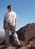
| Yea, canyoneering is an extreme sport... EXTREMELY dramatic!!! =p |
| | |
|
|
|
 Route Editor