|
| | | |
| |
|
| Hiking | 6.52 Miles |
3,571 AEG |
| | Hiking | 6.52 Miles | 6 Hrs 23 Mns | | 1.36 mph |
| 3,571 ft AEG | 1 Hour 36 Mns Break | | | |
|
|
| |
| Partners |
|
none
[ show ]
| no partners | | This amazing little wilderness area was our final stop in our short car camping tour of Colorado. I knew zero about the area, but came across it while buying some fuel at a sportsman store in Gunnison. We were looking at Nat Geo maps for Colorado and searching for ideas of what to do next when we noticed a map for the funny sounding wilderness area. Intrigued by the name and area, we bought the map on the spot and made that our final destination.
However, getting there was a small adventure. From a quick glance at the map it appeared Telluride was the nearest town to Mount Sneffles, so we plugged the mountain town into google maps and were on our way. Telluride did prove to be the closest town to Mount Sneffles, in fact, it is only 4.5 miles from the summit as the crow flies. Unfortunately, there is no real vehicle access from Telluride and we found ourselves on the complete opposite side of the mountain range and two hours from Ouray the town that Sneffles is reached from. Telluride ended up being a cool detour and I would recommend a visit to the town if in the area, however, it did add a couple hours to our drive, but all we could do was laugh at our error.
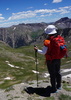
Despite silent objections and a little stress from the passenger, we were able to make it all the way to the top TH of Yankee Boy Basin. In my passenger's defense, the road up may have been one of the most aggressive and difficult roads I have driven, but the reward was an amazing car camping spot at 12,200 feet. I could not get over it, I had driven up to and we were camping at an elevation of just a few hundred feet below Humphreys! We enjoyed a simply amazing night on the tundra and woke up early the next day for an attempt at Sneffles and possibly a trip down to the Blue Lakes afterwards.
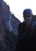
The first thing we noticed was the sign at the TH saying the peak was not dog friendly. We decided we would play it by ear, not knowing that it would be the snow that would end up being our biggest obstacle to the summit. Other than flipping open a map, I really did zero research on this one. Nevertheless, we continued on to the short but extremely steep climb to the saddle (13,600 feet) that offers the final route up Sneffles. The dogs did just fine for this part, but I knew it was the final chute that would prove to be the most difficult, so I was not getting overly excited about reaching the summit. About half way up, I passed two guys wearing helmets, carrying ice axes and traction. Both asked me if I had any traction or poles. I said yes on poles, but they are in the car and no on traction. The one guy laughed and said well there is a 35 yard snow field that needs to be negotiated to reach the summit and its "bullet proof" hard. He said I might be able to make it, but others were turning around.
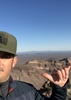
When I reached the saddle, I was surprised to see it was as bad looking and as nasty as the guy had described. I told Jackie it probably was not for her and definitely not for the dogs, but I was giving it a shot. So armed with a stick and about a 15 inch piece of pointed wood that I had found by the pure luck on the way up I took off up the boulder strewn chute to the snow field guarding the top. I met a girl who dejected explained that her boyfriend had turned her around and told her she was not going up. I told her that I was not in the habit of climbing up to 13,900 feet and turning around and they were welcome to share my sticks and follow me. The boyfriend said no way and started making his way down, but surprisingly she was game. I started kicking out one icy foothold after another and switching off with our "ice" sticks until we finally cleared the field. For future reference it takes like ten kicks to carve out a good foothold in "bullet proof" snow and this was a very tiring process. But we made it and after a borderline class three scramble and a wrong turn we were on the top! I know I sound redundant, but amazing views yet again. The views coupled with the challenge in making it to the top, immediately vaulted this one to the top of my short 14er list. Number nine on the trip and perhaps the best. From the summit, it was clear why the poor girl wanted to make it to the top so badly, she had her own sign made and everything, so we took a couple photos for each other and headed back down. Although, she was a little disappointed because her boyfriend was carrying their two summit brews, oops.
There was a little more traffic in the chute on our way back and a ray of sunlight was now on the snow, making it much more manageable. However, the majority of hikers were still wearing traction or carrying an ax, or poles at the very least. I found a nice run along the wall of the chute and threw the sticks back to my new summit partner and did not see her again. Jackie was with the BF and I told her his girl made it, which did not surprise him, but he had no regrets not going up. Jackie was a little disappointed, but I put it into perspective for her. I said at the end of the day, you still climbed a thousand feet higher than anyone in the state of Arizona can climb today and that there was no shame in hanging out at 13,600 while I finish off a peak. She liked the little analogy and we both headed down pretty satisfied with the first hike of our day.
From the summit, I could very clearly see the amazing Blue Lakes that were just a name on our map the day before. I knew right there, that we had to go see them and that is where we headed after slipping and sliding down the chute that served as the main route to the saddle.
The Blue Lakes were absolutely amazing and the views heading down into them almost other-worldy. Other than the additional AEG we enjoyed the area thoroughly and it certainly lived up to some of the hype we had read about the area after the fact. For example, some consider Mount Sneffles to be the most beautiful mountain in Colorado and it is perhaps its most photographed. There was also a reference to Mount Sneffles belonging to a stretch of the San Juan mountains that is sometimes referred to as America's Switzerland. I have never been to Switzerland, but I can attest to it being one of the most scenic areas I have visited and probably equal to some areas in the Sierra Nevada. Just an amazing area and a great cap to my three weeks in Colorado.
Our only regret was not making it down to the final Blue Lake, which from the summit was clearly the most picturesque, but it simply was not in the cards. I had already led Jackie and the dogs up to a nearly 14,000 foot saddle only to drop down them down two thousand feet so they can make another climb to the 12,900 feet Blue Lakes Pass, this was followed by another 2000 foot drop to the first of the three Blue Lakes that would inevitably be followed by an eventual climb out. Not daring to suggest we drop a few more hundred feet and another mile, or so to the final Blue Lake, we headed back after a picture perfect lunch along the lake with the pups.
The climb out was not that and we were happy to make it back to the car after maybe the toughest little six mile hike I have did in awhile. From the car it was the nerve racking trip back down the old mining road to semi-decent road and eventually the very scenic 550 all the way to Durango. |
|
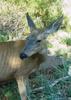
Wildflowers Observation Extreme
Simply put....a flower lovers paradise above the treeline.. |
|
| _____________________
| | |
|
|
|
 Route Editor