username
X
password
register
for free!
help
ArticlesGuidesRoutes
 
Photosets
 
 Comments
triplogs   photosets   labels comments more
Vista Trail - Boynton - 17 members in 24 triplogs have rated this an average 3.1 ( 1 to 5 best )
1, 2  Next
24 triplogs
login for filter options
Sep 28 2024
avatar

 Guides 69
 Routes 37
 Photos 3,010
 Triplogs 2,387

55 male
 Joined Oct 24 2010
 Phoenix,Az
Vista Trail - BoyntonSedona, AZ
Sedona, AZ
Hiking avatar Sep 28 2024
mt98dewTriplogs 2,387
Hiking2.00 Miles 117 AEG
Hiking2.00 Miles   1 Hour   30 Mns   1.33 mph
117 ft AEG
 no routes
Linked   none no linked trail guides
Partners none no partners
Morning hike to the vortex. The idea was to get there early to grab a covered parking spot, but trying to get 10 people moving in the same direction after a late night is like herding cats. Ended up getting there around 7:30 and having to park down the road. :( This added a bit to the mileage. Three of us scrambled to the top, much to the chagrin of the wives and mothers in the group. Never did find the “vibe” of the vortex. Not much of a hike, but it appealed to the wide age group (4-62) and we were able to visit a vortex.
_____________________
 
Jul 31 2020
avatar

 Guides 69
 Routes 37
 Photos 3,010
 Triplogs 2,387

55 male
 Joined Oct 24 2010
 Phoenix,Az
Vista Trail - BoyntonSedona, AZ
Sedona, AZ
Hiking avatar Jul 31 2020
mt98dewTriplogs 2,387
Hiking1.00 Miles 117 AEG
Hiking1.00 Miles
117 ft AEG
 no routes
Linked   none no linked trail guides
Partners none no partners
Belated post. Did this hike with my family in the late afternoon. Started from the Boynton TH. This is fee area. Parking for about 15 cars. Bathrooms are available. When we got there only 3 other cars were there, which was nice, as this can be crowded area. The hike in was very easy. There is a map at the TH and the trails are all well signed. Trail was fairly flat to the Vista turn off where there is some minor elevation change as you climb to the top of the knoll. There were a couple of other families taking in the views where arrived, but in the end we had the sunset to ourselves. Incredible views, great feelings....must be the vortex. This was one of the few days where Sedona had clouds and it added for a fantastic sunset. The kids climbed to the top of the spire, despite my wife's reservations. :scared: Very nice way to close our Sedona vacation.
_____________________
 
Apr 05 2019
avatar

 Guides 47
 Routes 96
 Photos 850
 Triplogs 385

81 male
 Joined Dec 24 2005
 Phoenix, AZ
Boynton Canyon Trail #47Sedona, AZ
Sedona, AZ
Hiking avatar Apr 05 2019
MEWhitemanTriplogs 385
Hiking7.60 Miles 1,040 AEG
Hiking7.60 Miles   3 Hrs   30 Mns   2.17 mph
1,040 ft AEG
 no routesno photosets
1st trip
Linked   linked  
Partners partners
hiazny10
This was my first time doing this hike and I really enjoyed it. While there was some uphill at the end of the canyon and on the Vista trail it wasn’t too taxing. The views through the trees were nice. Trailhead parking was tough so I parked at pullouts at the turn just before the TH.
_____________________
 
Apr 15 2017
avatar

 Routes 189
 Photos 7,244
 Triplogs 1,742

57 male
 Joined Apr 25 2011
 Goodyear, AZ
Boynton Canyon Trail #47Sedona, AZ
Sedona, AZ
Hiking avatar Apr 15 2017
NightstalkerTriplogs 1,742
Hiking4.30 Miles 737 AEG
Hiking4.30 Miles   2 Hrs   43 Mns   2.10 mph
737 ft AEG      40 Mns Break16 LBS Pack
 no routes
Linked   linked  
Partners none no partners
Went up to Sedona today to find some off trail cliff dwellings. Started on Boynton, went up to the Vista, and then made our way to the lower cliff dwellings on the east side of the Boynton trail. Great views of the resort below ;). Tried to find a route to the upper dwellings, but the suspected route looked like a shredder, so we headed over to Loy Canyon to do some exploring.
_____________________
 
Jan 01 2017
avatar

 Guides 94
 Routes 842
 Photos 22,068
 Triplogs 1,994

52 male
 Joined Sep 18 2002
 Tempe, AZ
Boynton trio, AZ 
Boynton trio, AZ
 
Hiking avatar Jan 01 2017
chumleyTriplogs 1,994
Hiking10.57 Miles 1,956 AEG
Hiking10.57 Miles   4 Hrs   55 Mns   2.29 mph
1,956 ft AEG      18 Mns Break
 
1st trip
Partners none no partners
The goal was to enjoy the stormy weather and hit a new trail. I decided on Boynton's Backyard after a quick glimpse on HAZ, and seeing that Mr Jamy, Dave, and Joe had enjoyed it I figured it was good for me too. I had hopes of getting up high enough to reach the snow, but I ended up turning around well short of the goal.

All the creeks and side drainages were running lightly and I was able to keep my feet dry in waterproof high-top boots. Unfortunately, as I got higher up in the backyard, the brush closed in and required me to go into full rain gear to stay dry. After my rain pants had soaked through and I wasn't close to the top, I admitted defeat and turned back down canyon. Along the way, I found an excellent use path on the southwest side of the creek. View all the GPS tracks posted here and you'll see what I mean. Absolutely avoid the official track and those that stay in the creek bottom. It is completely unnecessary and much slower!

Back on the trail, I changed into dry clothes before heading up the official Boynton trail. The views at the top were spectacular, and a nice waterfall was flowing off the cliffs above.

On the way out, I hit up the trifecta with the Vista Trail. By this point it was raining pretty hard again, but that didn't prevent a few tourists from venturing out as well. The rain soaked rocks prevented me from making the final move to the summit of the vortex butte, and the vortex energy had me all twisted in knots and craving a beer.

I hadn't done any of these hikes before so it was nice to visit a new area. The rain and temps in the 30s prevented what I'm sure is normally an obnoxiously crowded area that I would typically avoid like the plague.

I'd still like to explore farther up the backyard sometime.
 Meteorology
 Meteorology [ checklist ]
[ checklist ]  Flash Flood
_____________________
I'm not sure what my spirit animal is, but I'm confident it has rabies.
 
Feb 02 2014
avatar

 Guides 10
 Routes 673
 Photos 7,281
 Triplogs 4,660

67 female
 Joined Nov 17 2008
 phoenix, az
Mescal MountainSedona, AZ
Sedona, AZ
Hiking avatar Feb 02 2014
trekkin_geckoTriplogs 4,660
Hiking5.97 Miles 690 AEG
Hiking5.97 Miles   1 Hour   53 Mns   3.29 mph
690 ft AEG      4 Mns Break
 
1st trip
up early sunday morning to do this loop
deadman's pass to long canyon to mescal trail
took a side trip up vista trail
think there's a vortex up there
23 degrees to start with, maybe upper 30s when i finished
no wind, so it was fine
no people until i got back on deadman's pass
nice
_____________________
hazhole
 
Nov 23 2012
avatar

 Guides 8
 Routes 20
 Photos 512
 Triplogs 194

54 male
 Joined Apr 22 2008
 Mesa, AZ
Boynton Canyon Trail #47Sedona, AZ
Sedona, AZ
Hiking avatar Nov 23 2012
charlieazTriplogs 194
Hiking6.50 Miles 685 AEG
Hiking6.50 Miles
685 ft AEG
 no routes
1st trip
Linked   linked  
Partners none no partners
We arrived at the trail at about 9:00 am and made I way to the Vista Trail and up to the knoll where the infamous energy vortex is located. Then we went up the canyon looking for a good trail to the cliff dwellings. I located 5 separate ruins with the binoculars. The trail we chose took us right up to a vertical cliff so we back-tracked and continued on. We didn't demonstrate much effort, I know, but it was a day trip and didn't have time for more than one attempt. Further up the canyon it really cooled off. I had to throw on a beanie and long-sleeve shirt. We were probably a month too late for the leaves but still found a few trees with leaves still hanging on. No water in the stream. Very easy hike which made it busy with people. Beautiful scenery.
foliage observationfoliage observationfoliage observationfoliage observationfoliage observation
Autumn Foliage Observation Isolated
_____________________
 
May 28 2012
avatar

 Photos 25
 Triplogs 17

56 male
 Joined Jan 02 2012
 Prescott, AZ
Boynton Canyon Trail #47Sedona, AZ
Sedona, AZ
Hiking avatar May 28 2012
DarwinJrTriplogs 17
Hiking5.00 Miles 685 AEG
Hiking5.00 Miles   3 Hrs   45 Mns   1.54 mph
685 ft AEG      30 Mns Break
 no routes
1st trip
Linked   linked  
Partners none no partners
:PMIC: Boynton Canyon - Sedona - Memorial Day 2012

Did the Vista Trail Vortex-thing... ] ](*,)

...then to the end of Boynton Box Canyon...

..and back.

:PMIC:
_____________________
  1 archive
May 26 2012
avatar

 Guides 10
 Routes 673
 Photos 7,281
 Triplogs 4,660

67 female
 Joined Nov 17 2008
 phoenix, az
Boynton Canyon Trail #47Sedona, AZ
Sedona, AZ
Hiking avatar May 26 2012
trekkin_geckoTriplogs 4,660
Hiking7.73 Miles 1,567 AEG
Hiking7.73 Miles   5 Hrs   32 Mns   2.28 mph
1,567 ft AEG   2 Hrs   9 Mns Break
 no routes
Linked   linked  
Partners partners
tibber
was fortunate to get an invite from angela to hike in sedona saturday
plan A was wilson mountain, but when we arrived at midgely bridge at 8:30, it was chilly at 4500 feet with projected winds of up to 40 mph
that didn't sound very promising, so we decided to go with plan B, which was boynton canyon
i've done this before several years ago, but it was on angela's wish list and is so beautiful that i was happy to do it again
the canyon was sheltered, and we were quite comfortable
went along taking pictures and enjoying the scenery
at the end of the official trail, took a lunch break on the sandstone bench
in almost a natural amphitheater, you sit up high looking over the canyon - gorgeous
on the way back, we took two side trails, which we thought would lead to...something
didn't research this hike as well, and we wanted to do a second hike, so cut those short
afterwards we looked at a map that showed cliff dwellings in those areas - next time
took the vista trail to a spire and a vortex for another nice side trip
great views all around
enjoyed your company, angela, and thank you for the invite :)
 Geology
 Geology [ checklist ]
[ checklist ]  Cross-bedding
_____________________
hazhole
 
May 26 2012
avatar

 Guides 21
 Routes 1,183
 Photos 36,909
 Triplogs 1,571

69 female
 Joined Feb 26 2004
 Phoenix, AZ
Boynton Canyon Trail #47Sedona, AZ
Sedona, AZ
Hiking avatar May 26 2012
tibberTriplogs 1,571
Hiking7.73 Miles 1,567 AEG
Hiking7.73 Miles   5 Hrs   32 Mns   2.19 mph
1,567 ft AEG   2 Hrs    Break
 
1st trip
Linked   linked  
Partners partners
trekkin_gecko
I was pleasantly surprised Kelly was able to join me for my hike to Sedona. She suggested Wilson Mtn and though I hemmed and hawed I knew if anyone could help get me up that mountain it would be her so that would be the plan. We met at my house at 6AM for our drive north. The drive went so fast we blew by the Sedona turnoff and laughed at ourselves because: why were the windows fogging up a little, why were the trees taller and thicker and oh ya, there was that sign that said "chain up" area :doh: . SILLY!

Soon enough though, we were at Wilson Mtn TH at Midgley Bridge. I stepped out of Tonto and :o , what the heh? It was freezing. I looked thru my hike bag to see if I had anything to keep me warmer and all I had was a thin wind breaker. The cold probably would have been tolerable but the wind and projected wind gusts caused us to go for a Plan B. We didn't actually have a Plan B :-s but Boynton Canyon was the obvious choice.


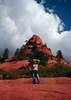
We visited with the ranger at Boynton TH for a moment under cloud covered skies. He told us there is a new trail off of Deadman's called Mescal that he said is pretty neat so we kept that in mind for the 2nd half of our hike day. We basically had the trail to ourselves until we started heading back; then it started getting a little more crowded with all sorts of different kinds of people. Getting to the end of the canyon and sitting down to observe what laid before you was all kinds of 8) . The tall canyon walls with the varnished waterfall and different colors was so sweet! :DANCE: (PS, Kelly brot me a very special yogurt: anybody wanna guess what flavor? are you thinking Glacier Park? if so you know it was HUCKLEBERRY.)

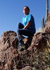
On our way back, we thot we would hit some of the side trails we saw. The first one took us up some pretty tough terrain. We were hoping maybe toward some Ruins but from what we could tell, no Ruins, just an incredible view :y: that we tried to stand upright long enough for a photograph as the wind up here was blowing big time! We scurried around a bit trying to see why we should be up here just in case we were missing something but to no avail.
We headed back down but it was a little hard to find the track back. Fortunately some other hikers had seen us and decided they needed to check it out. This worked out well as we realized we had gone down a tad too far before crossing back the way we came.

Our next little off trail was just to the creek and apparently nature's restroom as we caught a lady coming out :oops: . Back on the main trail, Kelly spotted some ruins off to the SE and moments later you couldn't see them anymore. A little further down we took what looked like one of the wider trails to the east. It narrowed down very quickly and we turned our way through the brush. It kept seeming like the trail would end but then you would see it again.

Soon we saw a tee-shirt hanging on a bush :-k so we thot we might be onto something. Later we came across a straw cowboy hat just before a bit of a dead-end. Kelly went right, I went left. She was able to get up on the bedrock of the canyon wall but determined it would be too much trouble to keep moving along the canyon wall. I could have found a way up onto the bottom of the canyon wall where I had stopped but based on her recon, decided it was time to just turn back.

We took a slightly different trail back as it branched off but it led basically nowhere :oplz: until one could finally see the main trail and a hop, skip, jump later we were on our way again. Not too much further, it was my turn to spot the ruin high up in the canyon wall to the SE? (I'm a little turned around in this canyon). On our way past the edge of the hotel property we went to inspect the 4 tall colored crosses. There were also several sawed tree trunks in a circle. Must be a vortex thing ;) .

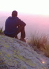
Next up was the trek over to the Boynton Vista. The sign said 2 miles RT. Well this satisfied us just fine and would give us a little more miles. I don't know who made the sign but they were way off base... and it was a fancy sign. It was about 1/4 mile to the Vista which was pretty crowded. We made an attempt to get up the Vista rock formation but the wind gusts scared me down after being 1/2 way up. Kelly was about 3/4 but decided to forego the final push.

This was just another absolutely beautiful :y: hike I would HIGHLY recommend. It has so much to offer. I couldn't quit smiling and I am sure Kelly got a little tired of the "WOW" after about the 25th time :D . We had a blast! So much bang for your buck!!
 Flora
 Flora [ checklist ]
[ checklist ]  Bear grass
 Named place
 Named place [ checklist ]
[ checklist ]  Doe Mountain  Kachina Woman Spire
wildflower observationwildflower observationwildflower observationwildflower observationwildflower observation
Wildflowers Observation Isolated
_____________________
For me, sometimes it's just as much about the journey as the destination.
Oh, and once in awhile, don't forget to look back at the trail you've traveled.
 
Jan 15 2012
avatar

 Guides 4
 Routes 93
 Photos 302
 Triplogs 698

51 male
 Joined Jul 05 2008
 Gilbert, AZ
Vista Trail - BoyntonSedona, AZ
Sedona, AZ
Hiking avatar Jan 15 2012
adeniumTriplogs 698
Hiking0.50 Miles 187 AEG
Hiking0.50 Miles      45 Mns   0.67 mph
187 ft AEG
 no routesno photosets
1st trip
Linked   none no linked trail guides
Partners none no partners
Slow and leisurely walk up the Vista Trail.
_____________________
 
Dec 15 2011
avatar

 Guides 170
 Routes 148
 Photos 5,914
 Triplogs 2,097

48 male
 Joined Apr 12 2004
 Tucson, AZ
Boynton Canyon Trail #47Sedona, AZ
Sedona, AZ
Hiking avatar Dec 15 2011
PrestonSandsTriplogs 2,097
Hiking2.70 Miles 365 AEG
Hiking2.70 Miles      45 Mns   3.60 mph
365 ft AEG5 LBS Pack
 no routesno photosets
Linked   linked  
Partners none no partners
Lunch break hike up Boynton Vista Trail, then on Boynton Canyon Trail for a bit.
_____________________
"…you never know when a hike might break out" -Jim Gaffigan
 
Jan 01 2011
avatar

 Guides 25
 Routes 36
 Photos 2,890
 Triplogs 658

39 male
 Joined May 30 2008
 Peoria, AZ
Vista Trail - BoyntonSedona, AZ
Sedona, AZ
Hiking avatar Jan 01 2011
hippiepunkpirateTriplogs 658
Hiking0.50 Miles 187 AEG
Hiking0.50 Miles
187 ft AEG
 no routes
1st trip
Linked   none no linked trail guides
Partners none no partners
New Year's morning, zero degree cold, snow, Sedona red rocks, sunrise, hot air balloons, icy facial hair, smiles.
 Meteorology
 Meteorology [ checklist ]
[ checklist ]  Rime Ice
_____________________
My blog: Mountain Tripper
My book: Arizona: A Photographic Journey
 
Oct 11 2008
avatar

 Guides 1
 Photos 484
 Triplogs 64

58 female
 Joined May 27 2006
 Apache Junction,
Vista Trail - BoyntonSedona, AZ
Sedona, AZ
Hiking avatar Oct 11 2008
DanaLee67Triplogs 64
Hiking1.30 Miles 187 AEG
Hiking1.30 Miles   1 Hour      1.30 mph
187 ft AEG
 no routes
1st trip
Linked   none no linked trail guides
Partners none no partners
Nice hike for people out of shape....like us! Short hike with a great destination! I don't know anything about vortexes, we didn't feel any energy other than the wind blowing us off the rocks! The high wind warnings didn't stop us, but it kept us from exploring too much up there!
_____________________
 
Apr 13 2008
avatar

 Photos 7
 Triplogs 177

45 male
 Joined Nov 14 2007
 Phoenix
Vista Trail - BoyntonSedona, AZ
Sedona, AZ
Hiking avatar Apr 13 2008
kgmolsonTriplogs 177
Hiking1.00 Miles 187 AEG
Hiking1.00 Miles      30 Mns   2.00 mph
187 ft AEG
 no routesno photosets
Linked   none no linked trail guides
Partners none no partners
_____________________
 
Jan 28 2008
avatar

 Photos 7
 Triplogs 177

45 male
 Joined Nov 14 2007
 Phoenix
Vista Trail - BoyntonSedona, AZ
Sedona, AZ
Hiking avatar Jan 28 2008
kgmolsonTriplogs 177
Hiking1.00 Miles 187 AEG
Hiking1.00 Miles      30 Mns   2.00 mph
187 ft AEG
 no routesno photosets
Linked   none no linked trail guides
Partners none no partners
_____________________
 
Sep 03 2007
avatar

 Triplogs 26

female
 Joined Oct 10 2006
 Flagstaff, AZ
Vista Trail - BoyntonSedona, AZ
Sedona, AZ
Hiking avatar Sep 03 2007
atticusTriplogs 26
Hiking0.50 Miles 187 AEG
Hiking0.50 Miles
187 ft AEG
 no routesno photosets
Linked   none no linked trail guides
Partners none no partners
_____________________
 
Mar 17 2007
avatar

 Triplogs 26

female
 Joined Oct 10 2006
 Flagstaff, AZ
Vista Trail - BoyntonSedona, AZ
Sedona, AZ
Hiking avatar Mar 17 2007
atticusTriplogs 26
Hiking0.50 Miles 187 AEG
Hiking0.50 Miles
187 ft AEG
 no routesno photosets
Linked   none no linked trail guides
Partners none no partners
_____________________
 
Oct 21 2006
avatar

 Guides 3
 Routes 4
 Photos 8,687
 Triplogs 931

46 male
 Joined Mar 28 2005
 Gilbert, AZ
Vista Trail - BoyntonSedona, AZ
Sedona, AZ
Hiking avatar Oct 21 2006
VapormanTriplogs 931
Hiking0.50 Miles 187 AEG
Hiking0.50 Miles      15 Mns   2.00 mph
187 ft AEG
 no routes
1st trip
Linked   none no linked trail guides
Partners none no partners
_____________________
Yea, canyoneering is an extreme sport... EXTREMELY dramatic!!! =p
 
Sep 03 2006
avatar

 Guides 11
 Routes 88
 Photos 2,649
 Triplogs 243

93 male
 Joined May 16 2005
 Scottsdale, AZ
Boynton Canyon Trail #47Sedona, AZ
Sedona, AZ
Hiking avatar Sep 03 2006
Al_HikesAZTriplogs 243
Hiking5.00 Miles 685 AEG
Hiking5.00 Miles
685 ft AEG
 
Linked   linked  
Partners none no partners
Hiked with my wife. Her first real hike. Great hike for a beginner. Included the Vista trail and the Vortex. Breakfast at the Coffee Pot Restaurant - home of 101 omelettes.
_____________________
Anybody can make a hike harder. The real skill comes in making the hike easier.
life is like a roll of toilet paper. The closer it gets to the end, the faster it goes. Andy Rooney
 
average hiking speed 1.82 mph
1, 2  Next

WARNING! Hiking and outdoor related sports can be dangerous. Be responsible and prepare for the trip. Study the area you are entering and plan accordingly. Dress for the current and unexpected weather changes. Take plenty of water. Never go alone. Make an itinerary with your plan(s), route(s), destination(s) and expected return time. Give your itinerary to trusted family and/or friends.

helpcommentissue

end of page marker