username
X
password
register
for free!
help
ArticlesGuidesRoutes
 
Photosets
 
 Comments
triplogs   photosets   labels comments more
Encinas Trail - 2 members in 11 triplogs have rated this an average 2.5 ( 1 to 5 best )
11 triplogs
login for filter options
Apr 05 2025
avatar

 Guides 93
 Routes 397
 Photos 4,984
 Triplogs 4,124

49 male
 Joined Jun 20 2003
 Tucson, AZ
Manville - Cactus Wren loopTucson, AZ
Tucson, AZ
Run/Jog avatar Apr 05 2025
fricknaleyTriplogs 4,124
Run/Jog11.33 Miles 916 AEG
Run/Jog11.33 Miles   2 Hrs   32 Mns   4.59 mph
916 ft AEG      4 Mns Break3 LBS Pack
 no routesno photosets
1st trip
Linked   linked  
Partners none no partners
Finishing off more trails in the far western part of Tucson district of SNP. I thought the sand might be tamped down a little from the rain - it was not :lol:
_____________________
hi
 
Jul 20 2024
avatar

 Guides 93
 Routes 397
 Photos 4,984
 Triplogs 4,124

49 male
 Joined Jun 20 2003
 Tucson, AZ
Saguaro West Tour 3, AZ 
Saguaro West Tour 3, AZ
 
Run/Jog avatar Jul 20 2024
fricknaleyTriplogs 4,124
Run/Jog16.75 Miles 1,399 AEG
Run/Jog16.75 Miles   3 Hrs   42 Mns   4.53 mph
1,399 ft AEG10 LBS Pack
 no routesno photosets
1st trip
Partners none no partners
Cam-Boh Trailstarted at camboh and took that to golden gate road. ran that out to picnic area.


Encinas TrailNice donwhill at sunrise. saw a sunrise rainbow, that was a first


Manville - Cactus Wren loop


Manville Trail


got hot and the humidity caught up with me the last couple miles, despite starting at 430. felt decent overall though
_____________________
hi
 
Feb 04 2023
avatar

 Guides 93
 Routes 397
 Photos 4,984
 Triplogs 4,124

49 male
 Joined Jun 20 2003
 Tucson, AZ
Saguaro West Tour 2, AZ 
Saguaro West Tour 2, AZ
 
Run/Jog avatar Feb 04 2023
fricknaleyTriplogs 4,124
Run/Jog15.15 Miles 1,296 AEG
Run/Jog15.15 Miles   3 Hrs   2 Mns   5.11 mph
1,296 ft AEG      4 Mns Break7 LBS Pack
 no routesno photosets
1st trip
Partners none no partners
Needed the miles today and being 5 days into another week of nights I didn't have the wherewithal to come up with something new, so I just hit up this route again. Really nice day. Solid effort given the exhaustion
_____________________
hi
 
Jan 21 2023
avatar

 Guides 93
 Routes 397
 Photos 4,984
 Triplogs 4,124

49 male
 Joined Jun 20 2003
 Tucson, AZ
Saguaro West Tour, AZ 
Saguaro West Tour, AZ
 
Run/Jog avatar Jan 21 2023
fricknaleyTriplogs 4,124
Run/Jog15.20 Miles 1,335 AEG
Run/Jog15.20 Miles   3 Hrs   3 Mns   5.12 mph
1,335 ft AEG      5 Mns Break5 LBS Pack
 no routesno photosets
Partners none no partners
Big route out in the foothills of SNP west. Started at Golden Gate TH and took that to Encinas trail at the Ez-Kim-In-Zin picnic area. Encinas out to the Cactus Wren/Manville Loop with a trip up Signal Hill. First time on some of these trails so it was nice to scratch them off the list. Nice cool, sunny and overall pleasant day.
_____________________
hi
 
Sep 22 2017
avatar

 Guides 187
 Routes 990
 Photos 12,079
 Triplogs 865

72 male
 Joined Jun 27 2015
 Tucson, Arizona
Encinas Sendero Esperanza Trails, AZ 
Encinas Sendero Esperanza Trails, AZ
 
Hiking avatar Sep 22 2017
markthurman53Triplogs 865
Hiking7.80 Miles 864 AEG
Hiking7.80 Miles   2 Hrs   56 Mns   3.12 mph
864 ft AEG      26 Mns Break10 LBS Pack
 
1st trip
Partners none no partners
Some days the trails you pick to hike are nothing to write home about. The Encinas trail is one of those. Started at sunrise at the EZ-Kim-In-Zin Picnic Ground and headed west to the Cactus Wren Trail crossing. Any time you start a hike in the desert at sunrise is a good hike, Love the desert in the morning. This trail has a lot of walking in sandy washes which isn't bad going down but the return trip up hill is a workout, especially if you maintain the 2.5 to 3 MPH pace. The one thing that really stood out for me was just how far down hill this trail goes. The views over the valley to the west are memorable although nothing like views from a peak. The northern portion of the Sendero Esperanza Trail to the junction with the Dobe Wash Trail is not real exciting either. This trail follows an old road that use to head off into the hills (In fact much of the Encinas Trail is along an old Road). The Sendero Esperanzo Trail gets a little more interesting and scenic as you head into the hills toward the Hugh Norris Trail. I turned around at the Dobe Wash Trail because next week I will be doing the Hugh Norris Dobe wash Loop and will finish up the Sendero Esperanza trail then.
_____________________
 
Apr 13 2015
avatar

 Guides 16
 Routes 81
 Photos 1,269
 Triplogs 1,145

51 male
 Joined Apr 30 2008
 Tucson, AZ
Encinas TrailTucson, AZ
Tucson, AZ
Hiking avatar Apr 13 2015
azdesertfatherTriplogs 1,145
Hiking12.35 Miles 1,782 AEG
Hiking12.35 Miles   4 Hrs   15 Mns   3.40 mph
1,782 ft AEG      37 Mns Break
 
no photosets
1st trip
Did a nice loop from Ez-Kim-in-Zin parking lot...I did all of Encinas, then hiked the 0.4 mi back to Cactus Wren and took it south to Signal Hill. From Signal Hill I followed the road out of that picnic area to the Wild Dog Trail. I took Wild Dog to the end, then did Valley View real quick and back, then picked up Bajada Wash heading south to Hohokam Road, where I crossed the road to pick up the west end of Hugh Norris. I took Hugh Norris to Sendero Esparanza going north to return to Ez-Kim-in-Zin parking lot.

Encinas was part wash and part old road, a slight decline down to Cactus Wren. The others were ok also...the better trail was Hugh Norris for sure. Nice views. It incidentally was the real trail with any notable elevation (though Sendero Esparanza was a quick drop of elevation from the ridgeline that Hugh Norris started off as and continued as, on the way to Amole & Wasson Peaks).
_____________________
"I went to the woods because I wished to live deliberately, to front only the essential facts of life, and see if I could not learn what it had to teach, and not, when I came to die, discover that I had not lived." — Henry David Thoreau
 
Feb 20 2014
avatar

 Photos 19
 Triplogs 13

69 female
 Joined May 15 2008
 Tucson, Arizona
Encinas TrailTucson, AZ
Tucson, AZ
Hiking avatar Feb 20 2014
amcole6Triplogs 13
Hiking1.56 Miles 164 AEG
Hiking1.56 Miles   1 Hour   5 Mns   1.44 mph
164 ft AEG
 no routes
1st trip
Linked   none no linked trail guides
Partners none no partners
This was a delightful little hike! I did not do a long distance. My main goal today was to get a Virtual geocache on the Encinas Trail, "Surveying the Desert", GC27BF. True geocaches are not allowed in Saguaro National Park and so this virtual, requiring information from a benchmark, works instead.

I approached from Tucson by way of Golden Gate Road. The road was in great shape, recently graded, and fine for passenger cars. While I usually always cache with my dog, they are also not allowed in Saguaro National Park so today, I hiked alone. I parked at the Ezkiminzin Picnic area. Not finding a real trailhead in the picnic area, I may have missed it, I just dropped down the hill to the wash and headed generally west until I figured out that the trail was basically a mostly level, open wash, quite sandy, which made the journey a bit more work.

The views were nice, the trail empty, and the smaller wildflowers were starting to bloom. Again, I only did about .8 miles in and then returned. The climb back out was a bit of a workout for me, but if I can do it, anyone can! :) I took an hour, but that was with lots of stops for taking pictures, gathering the needed info at the benchmark, and just goofing off.

Lastly, originally I was going to do this as a night hike with a friend. Last minute, I got lucky and found that there is a sign at Golden Gate Road and Picture Rocks prohibiting entrance on Golden Gate after sunset. I am glad I didn't waste a trip!
wildflower observationwildflower observationwildflower observationwildflower observationwildflower observation
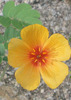
Wildflowers Observation Light
Small wildflowers in bloom as well as the Creosote. Lupine are growing in the wash and will likely be blooming in a couple weeks.
_____________________
 
Feb 12 2014
avatar

 Guides 1
 Routes 136
 Photos 22,415
 Triplogs 1,041

77 male
 Joined Feb 28 2003
 Tucson, AZ
Saguaro NP West Loop, AZ 
Saguaro NP West Loop, AZ
 
Hiking avatar Feb 12 2014
rwstormTriplogs 1,041
Hiking6.00 Miles 400 AEG
Hiking6.00 Miles
400 ft AEG
 no routes
1st trip
Partners none no partners
SAHC - Group
Judy and Pete Cowgill led us on a nice loop hike from the the Sendero Esperanza TH along Golden Gate Road. We proceeded west on the Encinas Trail, which we picked up across the road by the picnic area, then bushwhacked to the Golden Gate Road west of Apache Peak. From there we took the Wild Dog Trail southbound until we reached the Bajada Wash Trail, which we followed until we reached Hohokam Road. After a section of road walking, we headed east on the Dobe Wash Trail for a ways, before bushwhacking over to the Blue Windmill and old wildlife water pond (dry). After a break there, it was a cross country jaunt back toward the parking area, finishing with a short section of the Sendero Esperanza Trail. Fun desert stroll! :)
 Culture
 Culture [ checklist ]
[ checklist ]  Windmill
wildflower observationwildflower observationwildflower observationwildflower observationwildflower observation
Wildflowers Observation Isolated
_____________________
 
Jul 04 2011
avatar

 Guides 2
 Routes 4
 Photos 3,873
 Triplogs 362

51 female
 Joined Feb 12 2008
 Tucson, AZ
Encinas TrailTucson, AZ
Tucson, AZ
Hiking avatar Jul 04 2011
sirenaTriplogs 362
Hiking4.50 Miles 480 AEG
Hiking4.50 Miles   1 Hour   15 Mns   3.60 mph
480 ft AEG
 no routesno photosets
1st trip
Linked   none no linked trail guides
Partners none no partners
Weather was great for the hike out, but by the time I turned back the cloud cover was gone and it was toasty! A yawn of a hike that I wouldn't probably waste my time on in the wintertime, but it was good to at least get out for a bit.
_____________________
 
Feb 01 2011
avatar

 Triplogs 12

male
 Joined Dec 05 2006
 Tucson, AZ
Encinas TrailTucson, AZ
Tucson, AZ
Hiking avatar Feb 01 2011
jivensTriplogs 12
Hiking6.90 Miles 680 AEG
Hiking6.90 Miles
680 ft AEG
 no routesno photosets
1st trip
Linked   none no linked trail guides
Partners none no partners
This hike is pretty boring. You do have the advantage of hiking between two areas with picnic tables so you can relax and eat and have some shade. Nothing much to see except a couple of saguaros, although heading down hill you get better views than on the way back. This would be a good trail on which to horseback ride, and I did in fact run into a man doing just that. Definitely not a summer hike.
_____________________
 
Dec 03 2008
avatar

 Guides 93
 Routes 397
 Photos 4,984
 Triplogs 4,124

49 male
 Joined Jun 20 2003
 Tucson, AZ
Encinas TrailTucson, AZ
Tucson, AZ
Hiking avatar Dec 03 2008
fricknaleyTriplogs 4,124
Hiking6.90 Miles 680 AEG
Hiking6.90 Miles   2 Hrs   10 Mns   3.18 mph
680 ft AEG
 no routes
1st trip
Linked   none no linked trail guides
Partners none no partners
Out before a beating at work. Nice pleasant stroll.
_____________________
hi
 
average hiking speed 1.44 mph

WARNING! Hiking and outdoor related sports can be dangerous. Be responsible and prepare for the trip. Study the area you are entering and plan accordingly. Dress for the current and unexpected weather changes. Take plenty of water. Never go alone. Make an itinerary with your plan(s), route(s), destination(s) and expected return time. Give your itinerary to trusted family and/or friends.

helpcommentissue

end of page marker