|
| | | |
| |
|
| Canyoneering | 9.63 Miles |
859 AEG |
| | Canyoneering | 9.63 Miles | 1 Day | | |
| 859 ft AEG | | | | |
|
|
| | |
| Partners |
|
[ show ]
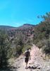
| partners | | | Got in a fun and easy weekend trip up to the Agua Fria NM. We had been looking at this one for a while as a backpack trip going from Silver Creek down to Sunset Point, but we had considerable doubts about water availability due to the lack of winter rain this year. We got the idea to park an extra car at Badger Springs for some water just in case there was not much to filter, but then got to thinking that we could just leave our big packs there as well and do the trip as a series of two day hikes, with an easy 2 mile backpack in the middle. Saturday started off great, we started hiking about 10 after we set up our shuttle and took a nice leisurely pace. Turns out that the small storm we had in Phoenix the weekend before was more than enough in the northern part of the state to fill up the Agua Fria. There were still some large dry expanses, but pools to moderate flow were the norm for this part of the trip. We made it back to the Earthiest's car about 2:30, grabbed our big packs, and headed back for the confluence. Great little spot right on the bank of the river, nice bit of shade and we were able to scavenge a surprising amount of wood for a campfire. Unfortunately, the Droog got a pretty wicked headache and started feeling ill, after a few hours he thought he would be better off spending the night at home. We helped get his gear all packed up, doused the fire, and hiked back out Badger Springs wash to get him to his truck parked down by Sunset Point. Hiked back in to camp for the rest of the night, weather was great and the wind stayed calm until about 9 or so Sunday morning. The Earthiest and I spent a nice lazy morning in camp since we were not completing the second leg of our trip, made it back to Phoenix in time to catch some lunch with my family. Bummer that we could not get the whole hike in, but a fun trip nonetheless. |
  |
Badger Spring Wash |
Pools to trickle |
Pools to trickle |
| | | A few small pools and wet sand, large pools and good flow at confluence with AF | | _____________________
| | |
|
|
|
 Route Editor