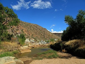
Badger Springs offers a short trail for non-motorized users within the Agua Fria National Monument. The trail leads down the Badger Springs Wash to the Agua Fria River canyon, an area rich in archaeological resources. The confluence of Badger Springs and the Agua Fria is the location of a fantastic panel of petroglyphs. At the confluence, hikers can travel either upstream or downstream to explore this high desert canyon. Most years the river flows through early summer. Mule deer, white-tail deer, javelina, and coyotes roam the area.
Consider: This seems to be the only posted trail in the Agua Fria National Monument. For a much better extended option check out Agua Fria via Badger.
WARNING! Hiking and outdoor related sports can be dangerous. Be responsible and prepare for the trip. Study the area you are entering and plan accordingly. Dress for the current and unexpected weather changes. Take plenty of water. Never go alone. Make an itinerary with your plan(s), route(s), destination(s) and expected return time. Give your itinerary to trusted family and/or friends.
Permit $$
None
Directions
Road
FR / Jeep Road - Car possible when dry
To hike Off Interstate 17, take exit #256, the Badger Springs exit. Follow the rough, sometimes muddy gravel road for approximately one mile east to the trailhead parking area.
 Route Editor


 Badger Springs offers a short trail for non-motorized users within the Agua Fria National Monument. The trail leads down the Badger Springs Wash to the Agua Fria River canyon, an area rich in archaeological resources. The confluence of Badger Springs and the Agua Fria is the location of a fantastic panel of petroglyphs. At the confluence, hikers can travel either upstream or downstream to explore this high desert canyon. Most years the river flows through early summer. Mule deer, white-tail deer, javelina, and coyotes roam the area.