|
| | | New River Mountains Ridgeline, AZ | | | |
|
|
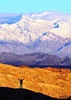
New River Mountains Ridgeline, AZ
| | |
| |
|
| Hiking | 11.59 Miles |
3,921 AEG |
| | Hiking | 11.59 Miles | 7 Hrs 28 Mns | | 1.76 mph |
| 3,921 ft AEG | 53 Mns Break | | | |
|
|
| |
| Partners |
|
none
[ show ]
| no partners | | It's been on my winter wishlist to get out on the ridgeline before the weather gets too warm, but with the hassle of setting up a shuttle, too many influencer-tourists, and the Ren Fest, I opted to find another ridgeline instead.
A few weeks ago on Brooklyn Peak, I caught a view of some mountains that looked pretty impressive, and piqued my interest. I hadn't even looked at a map of this area since truck-quad-boat-cabin-chick-apelli cheated by getting deep in here on his OHV a decade ago.
I put some possible routes on a map and headed out. The drive turned out great. FR41 and FR37 were in fine shape and the uncertainty of FR603 seemed like it might be tolerable. Until it wasn't. Unfortunately by the time I decided I didn't want to continue, there was no option for stopping, pulling over, or turning around. So after a mile farther and a dozen scrapes or clunks of rock on metal, I settled into a nice spot to park.
I started with a 1300 foot ridgeline ascent to the summit of Benchmark Mountain, a rugged and rocky summit with fun scrambling. Along the way I took a short detour over to point 5167 along the ridge to check out some rocks that looked promising and some unusual cattle exclosure structures.
From Benchmark, I had to go north a bit before being able to descend a ridge to the saddle at the upper end of Top of the Mountain Canyon. From here it was a 500-ft climb to the unnamed 5,936ft highpoint of the New River Mountains. Both Benchmark and the highpoint had summit registers with only about a dozen entries over their 40 year lifespans. These points don't see a whole lot of visitation!
Next, I headed south-ish following the ridge for about 3.5 miles, all at an elevation above 5500ft, heading for the peak surveyed with the "New River 2" benchmark and with a communications antenna structure. Along the way I came within 15-feet of something in the brush that vocalized a pissy growl-hiss and rustled away under the cover of the foliage. I never saw what it was, but the sound was reminiscent of the mtn lion that I almost got to pet in Virgus Canyon years ago. So while I broke into song with a rendition of my Grammy-nominated lyrical masterpiece "I'm a people" I wondered what it could have been. I'd think a lion would have been large enough for me to see some part of it, so perhaps just a sweet little bobcat or a cute fox instead? Not sure what else could have made that sound. Oh well. Didn't die.
Once up on the New River 2 antenna peak it was a steep downhill toward the southwest and the Maricopa-Yavapai County border marked by Frustum #24. It was a few feet downhill from what should have been the "Summit" benchmark. Sadly, it appeared that this one has been stolen as there was a hole in the ground surrounded by the lumber and wire from a former height of light structure. I also did not find any reference marks here.
From the Summit Frustum I followed the ridge down to a saddle where the former FR603 once ended. This old two-track has not been driven in many years, presumably not since flood erosion that followed the 2005 Cave Creek Complex Fire that burned this area.
My plan was to follow the old roadbed back to my truck, but I decided to make the 400 foot climb to the Bilby benchmark, which was still intact (though I didn't see either reference mark -- and didn't put a lot of effort looking for them either).
I followed the ridge for half a mile -- it was brushy and rocky -- before heading down the slope toward the road half a mile downstream of the dry Brushy Tanks. It was 3.5 miles on the old roadbed back to the start. It's not much more than a singletrack anymore, with some places totally overgrown and every drainage completely blown out from flooding.
I stopped by all the marked springs along the way, surprised that there was at least some water in all of them. The weather was great all day. A cool breeze helped knock down the warmth of the sun and the elevation kept temps mostly in the low 60s, but just 55 during my break on the high point.
The two mile drive on the 603 back to 37 took half an hour but I managed to limit rock hits to less than a handful! Beautiful views on the drive along the 41 with a newfound familiarity looking back at the ridgeline I had just traversed. |
 |
Brushy Tanks |
Dry |
Dry |
| | | Aerial photo looks like a lake. Today it was a dustbowl. |
  |
Bull Spring |
Dripping |
Dripping |
| | | Dripping is a stretch. It looked dry and the trough is full of dirt, but a few yards upcanyon I did find two spots with very small, shallow pools. Maybe 2 quarts total. |
|
Grapevine Canyon |
Pools to trickle |
Pools to trickle |
| | | No flow in Grapevine proper, but New River was lightly flowing at the Grapevine confluence. |
|
Lion Canyon |
Pools to trickle |
Pools to trickle |
| | | Lion was dry, but New River had light flow at the Lion confluence. |
|
Lion Canyon Spring |
Dripping |
Dripping |
| | | Appears to be a seep in the bottom of the canyon. A couple of shallow pools of clear cool water. Just a drip of flow for a few yards in the bedrock. |
|
Magazine Canyon |
Pools to trickle |
Pools to trickle |
| | | Magazine was dry, but New River was lightly flowing at the Magazine confluence. |
|
Tunnel Spring |
Dripping |
Dripping |
| | | I didn't go in the tunnel and it seemed dry at the opening. But there is piping in place leading to a water tank and trough down the hill. That trough was full of clear water. | | _____________________
| I'm not sure what my spirit animal is, but I'm confident it has rabies. |
| | |
|
|
|
 Route Editor