|
| | | |
| |
|
| Canyoneering | 2.00 Miles |
720 AEG |
| | Canyoneering | 2.00 Miles | 6 Hrs | | 0.38 mph |
| 720 ft AEG | 45 Mns Break | | | |
|
|
| | |
| Linked |
|
none
[ show ]
| no linked trail guides |
| Partners |
|
none
[ show ]
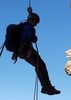
| no partners | | Descend Frye Creek Canyon | 08.24.14
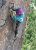
We rappeled through clear, flowing waterfalls of the beautiful smooth-surfaced granite canyon eroded by the cold water perennial stream of Frye Creek on the north side of Mount Graham, 10,719, the most-prominent peak in Arizona.
Frye Creek Canyon
Coronado National Forest, below Mt. Graham and near Safford, Ariz.
Rating: 3CII
Rappels: 8-10, with the longest about 125 feet. Rappel count in approximate feet: 125, 75, 60, 65, 40, 60, 70 and 50
Anchors: Except for the first pinch-point natural anchor, nearly all rappels have been anchored with recently installed dual bolts with rock-colored coated bolt hangers. There are some poorly attached, questionable nylon hand lines and one anchor constructed of webbing attached to a steel T fence post hammered into a crack. Don't use it, as its spine has been removed, and it wobbles out of the crack. This drop can be safely bypassed on a rock slope on canyon left along a hand line. Some rappels are two-staged, and look carefully so that the next set of bolts are not mistakenly passed by.
Total distance: Approx. 2 miles
Duration: 3-7 hours, depending on size and speed of group
Elevation: 5,602 feet at canyon entrance and 4,882 feet at canyon exit at Fry Creek Reservoir = 720 feet of descent
GPS coordinates: Park at N 33.49073 | W 111.90112 and enter canyon at N 32.74435 | W 109.83844 at 5,602 feet elevation
Conditions: Air temperature of 95-85 degrees, mostly clear to some cumulus clouds later in the day and some cool breeze in the canyon
Water conditions: Steady, clear water flow, 60-66 degrees. Most rappels involved navigating over, in and through active waterfalls. The U.S. Geological Survey streamflow meter gage station registered 1.0 cubic feet of water a second on Aug. 24, 2014:
http://waterdata.usgs.gov/az/nwis/curre ... station_nm
Gear: Wetsuits not required during the hottest days of the summer, but canyoneering shoes with 5.10-type rubber soles are highly recommended to try to stick to the black algae coated smooth, slick granite.
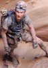
Wildlife: We spotted a large coatimundi as we entered the canyon, green lizards, canyon frogs and large water beetles
*Cautions: Extreme care should be taken in navigating the super slick polished granite water chutes and waterfalls, which are coated with an extremely slippery black algae.
Also, some of the water chutes are eroded deeply, but narrowly, into the granite. Be careful not to knock your knees and elbows against the granite, get stuck in the narrow-cut rock chutes or choke in the active waterfalls. Another hazard are the water slides, which are tempting for a seemingly, fun, quick slide into the pools, but beware, as some have hidden underwater benches, that will stop your slide dead, unexpectedly. Rather, bend your knees, and slide slowly.
Also, be aware of the crowds of local hangers-on hanging out at the swimming holes at the reservoir. And, you cannot ignore the "Class of 2014" and "Class of 2015" and other amateur graffiti defacing the walls of the canyon with black spray paint at the final waterfall and pool before the creek enters the Frye Mesa Reservoir, dammed for local drinking water. We picked up and hauled out two bushels of beer cans, bottles and other assorted trash.
Some rappels can be safely bypassed by downclimbing. Water holes are mostly waders, but some are short swimmers at depths of 6-feet-plus. There were no keeper potholes when we descended the canyon, but there may be keepers in drier conditions. A beached-whale technique is required to exit some of the pools. Plenty of bushwacking is required, some of it through stands of heavy poison ivy. Gloves and long pants are recommended.
The canyon plays as two parts with the first half ending at a perfect place within sight of the trailhead -- a great place to stop and have lunch before bushwacking to the second set of waterfalls.
Getting there: Park at the gate leading to Frye Mesa Reservoir. Either hike or continue driving a 4 x 4 up the final .67 miles of rough, rocky road to the official trailhead of Frey Canyon Trail #36 and park by the gate. Hike up on your left up a faint trail and find a suitable location to enter the canyon. A good place is just left of the U.S. Geological Survey streamflow meter gage station.
With Jason N., Tommy, Josh, Megan and Jennifer
*Note: This trip report is meant as an informational report only. Do not rely on it fully as trip beta. Use your own judgement and caution in this canyon, as flowing water, slick surfaces and changing conditions are inherently dangerous.
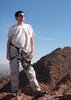
-- Matt Kalina | Scottsdale, Ariz. | 08.24.14 |
| _____________________
| | |
|
|
|
 Route Editor