|
| | | |
| |
|
| Hiking | 13.00 Miles |
3,200 AEG |
| | Hiking | 13.00 Miles | 5 Hrs 20 Mns | | 2.48 mph |
| 3,200 ft AEG | 5 Mns Break | 10 LBS Pack | | |
|
|
| |
| Linked |
|
none
[ show ]
| no linked trail guides |
| Partners |
|
[ show ]
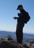
| partners | | At least I now know why no one ever comes out here to do this peak ( and Harcuvar Peak, too).
I had this on my wish list for a long time. I was considering Harcuavar, but Scott preferred Smith as there was a road to follow. I was fine with that. It took longer to get here than I thought, and we left town later than expected, so we started later. This was OK, as everything went smoothly for me, and though rushed I was able to tag the summit, snap some pics and head down. It was chilly and windy, so I didn't want much more. This, like Harquahala, and possibly Harcuvar, may be better in Spring when it is warmer, than in winter after a cold front.
Following the description directions was very easy, but the road that parallels the utility lines is over grown. I had to back up out of an extremely eroded section, and my AWD saved me when I was able to get up out of that section onto a newer crude 2 track above it, before continuing on. Lots of new AZ pinstripes on the car, but whatever, I bought it for that! I must have creosote somewhere under the car (drove over a fair amount of crushed ones) as I smelled it in the garage when I got home. Personally, if I did this again, I would drive the official Smith Peak Road, which is minimally signed and departs from the west heading section of Eagle Eye Road. It goes to the summit, and is graded up high. Would I hike this summit? Maybe.
When it comes to the desert, so far my experience with desert peaks has been that the I-10 corridor south, is where the action truly is. This area is slightly interesting to look at, but it simply isn't as rugged appearing, diverse (to me) or as appealing as the area south of Harquahala down to the Mexican Border, or I-8, at least. The valley to the north, and the appearance of larger hills, uninteresting summits, and the sea of endless eroded hills did not spark my interest or have me thinking that I want to head over there. This is OK. Not everywhere can be like the Eagle Tails, or Bighorn Mts. I should have been able to see the Hualapai Mountains, and the Juniper Mts, or some other lesser range west of the Colorado Plateau, which is nice. I was not able to see familiar summits like The Peaks, or Bill Williams. Granite, Mt Union, perhaps some other Bradshaw Summits I am unfamiliar with, those were there. I was able to make out the Mazatzals, I think, and either the 4-Peaks or something else, and I believe I could see the McDowell Mountains clearly.
South, that was what where the action was. However, Harquahala blocked most of it! Through a pass, I could see a nice line up of Bighorn, Saddle, and Woolsey! I like that. The White Tanks, and Estrellas were there, and to the SW, the Kofa Mountains. At first, I thought Castle Dome, but I realized that is not likely, and since I could not see the Eagle Tails, I must be looking more at the Signal Peak area, and a spire to the east of that massif, but not Castle Dome. Besides, Black Mt or Mesa was just north of it. Unless I get a wild hair, Harcuvar, to the west, was there, but I am not thinking of that anytime soon.
Scott only went part of the way, and really I don't think he would have cared. I like a new summit, and enjoyed my time out, but in my world of benefits to cost, this is a one time hike with high cost and only slightly greater benefits via this route. Had I damaged my car, I would be a lot less happy. Next time, should that ever happen, I will drive the graded road to the near the top. Enjoy the views with none of the pin stripes. |
| _____________________
| | |
|
|
|
 Route Editor


 seems pretty unlikely.