username
X
password
register
for free!
help
ArticlesGuidesRoutes
 
Photosets
 
 Comments
triplogs   photosets   labels comments more
Montezuma Sleeping - 4 members in 5 triplogs have rated this an average 4 ( 1 to 5 best )
5 triplogs
login for filter options
Apr 14 2023
avatar

 Guides 59
 Routes 1,100
 Photos 1,191
 Triplogs 1,290

male
 Joined Jan 01 2023
 Arizona
Torote Loop - NorthPhoenix, AZ
Phoenix, AZ
Hiking avatar Apr 14 2023
pseudalpineTriplogs 1,290
Hiking17.72 Miles 6,124 AEG
Hiking17.72 Miles   9 Hrs   33 Mns   2.08 mph
6,124 ft AEG   1 Hour   3 Mns Break
 
1st trip
Partners none no partners
I'd guess that every Arizona outdoor enthusiast has a bucket list ready for days like today. Well, one of the many on my list was this hike. The forecast was for a break in the recent hot temperatures. The day did not disappoint. Almost perfect, except for those pesky gnats! I had three goals on this hike. The first was to find Mel's bandana she had lost on our previous trip to Hayes Peak. The second was to not get bit by a viper. The final goal was linking up three of the Sierra Estrella's main summits. I closely followed our previous route and quickly found the lost bandana, so after that I was elated to put the phone away, transitioning into sheep mode and trying to step up the pace. Hayes Peak didn't seem that difficult, as well as most of the traverse south towards Montezuma Sleeping. There surprisingly were well-worn sheep trails in many places on the ridgeline and remnants of the 1945 plane crash. Nearing the north side of MS though, the topography became more challenging and didn't really let up at all until Quartz Peak. I saw one large ram below me when ascending MS. He quickly distanced himself from me with what seemed like very minimal effort. An old friend gave me some advice about this ridgeline, stating that it's best to stay on the ridgeline proper. I tried to keep to that great advice, except the last three very rocky peaks before reaching Quartz seemed tough to go over, so I traversed the northeast side of them. It was a jenky, grueling bushwhack to say the least. If (unlikely) I repeat this route, I'd try it CCW, up the Quartz Peak trail first and try to crest those three peaks when fresher in the hike. This is a more difficult hike. It would be insane to attempt this without prior experience hiking. : wink :
 Culture
 Culture [ checklist ]
[ checklist ]  Trash Hauled Out
  7 archives
Dec 13 2020
avatar

 Guides 73
 Routes 176
 Photos 10,174
 Triplogs 2,324

46 male
 Joined Sep 08 2006
 
Montezuma SleepingPhoenix, AZ
Phoenix, AZ
Hiking avatar Dec 13 2020
JimTriplogs 2,324
Hiking8.00 Miles 2,677 AEG
Hiking8.00 Miles   7 Hrs      1.26 mph
2,677 ft AEG      40 Mns Break10 LBS Pack
 no routes
Linked   none no linked trail guides
Partners none no partners
Rain finally came and so I was able to journey to the Rainbow Valley to hike this. I had been planning to hike it last spring, but my toe injury put a stop to that. After the dry summer, I didn't really feel like dealing with more dust, so I was putting this off until it rained, and it was worth the wait. The road was nicely packed and almost free of any of the normally powder dry dust on Riggs Rd. It won't last. I came and went by the north route and I-10, as well as the brief section of the 303 dumping on to Cotton Lane. I did think about driving home using the south route, but I finished too late to see anything.

Once again, this is one of the hardest off trail peaks in this range. Everything still looks dry, but the soil is moist. Elephant Trees are just starting to leaf out after the rain, and smell great as usual. The summit was nice, and the views great as always. It was, however, very cold on top, and pretty chilly for the entire hike. The wind didn't help.

I didn't see or hear much wildlife. Guess the season is wrong, and it was cold.

Route finding was pretty easy from memory, but this is a straight forward summit.
 Flora
 Flora [ checklist ]
[ checklist ]  Elephant Tree
_____________________
🍭
 
Mar 21 2020
avatar

 Routes 27
 Photos 189
 Triplogs 29

52 male
 Joined May 27 2013
 Apache Junction,
Montezuma SleepingPhoenix, AZ
Phoenix, AZ
Hiking avatar Mar 21 2020
TeamBillyGoatTriplogs 29
Hiking4.00 Miles 2,677 AEG
Hiking4.00 Miles
2,677 ft AEG
 
1st trip
Linked   none no linked trail guides
Partners none no partners
A close friend of mine took these photos. I wasn’t actually there. He’s really good at photo shop too. But he told me this was an amazing hike. A real kick in the pumpkin. He also said you better be in top physical condition to attempt this. And bring plenty of water and electrolytes. 😅
_____________________
  2 archives
Mar 23 2019
avatar

 Guides 73
 Routes 176
 Photos 10,174
 Triplogs 2,324

46 male
 Joined Sep 08 2006
 
Montezuma SleepingPhoenix, AZ
Phoenix, AZ
Hiking avatar Mar 23 2019
JimTriplogs 2,324
Hiking8.00 Miles 2,677 AEG
Hiking8.00 Miles   7 Hrs   30 Mns   1.14 mph
2,677 ft AEG      30 Mns Break10 LBS Pack
 no routes
Linked   none no linked trail guides
Partners none no partners
Harder than anticipated, but off trail often can be. I do not recommend ascending the gully that trends North to south, just off the summit, and instead suggest using the slope that is the natural extension of the drain you hike up.

Not a highly visited peak, but some do come. Pretty challenging. Did the trick.
wildflower observationwildflower observationwildflower observationwildflower observationwildflower observation
Wildflowers Observation Substantial
A sneezy slope covered nightmare of flowers!
_____________________
🍭
 
Dec 26 2016
avatar

 Guides 10
 Routes 673
 Photos 7,281
 Triplogs 4,660

67 female
 Joined Nov 17 2008
 phoenix, az
Montezuma Sleeping, AZ 
Montezuma Sleeping, AZ
 
Hiking avatar Dec 26 2016
trekkin_geckoTriplogs 4,660
Hiking10.45 Miles 3,484 AEG
Hiking10.45 Miles
3,484 ft AEG
 no routes
1st trip
Linked   linked  
Partners partners
johnlp
john had the day off, so we made the night before decision to hit montezuma sleeping in the estrellas
he's done all five, but this is his favorite, and along with montezuma peak, it's been on my to-do list
the drive in was fine in my truck, sand packed down somewhat with recent rains
some frost on the sand and on rainbow valley vegetation
turned left where you would turn right for quartz and parked at about the 5th transmission tower
probably 40 degrees when we got going at 8:25
john had drawn up a track in route manager that went up a drainage
it's too bad we didn't follow it on the ascent :lol:
ended up north and took a different one, which worked, although we eventually had to bushwhack up to a ridgeline
we could have topped out on the north side of the peak, too
this hike is 100% off trail
except for the lower open desert, there is nowhere to relax; you always have to watch your footing and you're never on level ground
let's just say that we ended up making this hike more difficult than it needed to be
navigational and electronic issues led to some backtracking and a long day
the summit is steep with some scrambling, loose rock and sticker bushes
the same could be said for anything along the ridgelines
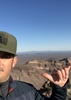
it's a cool summit area - great views of ord, four peaks and the pinals with snow on top
a bit chilly so we didn't stay long
our descent line was a good one
the initial drop into the original drainage wasn't fun, but the drainage had little brush, decent footing and some cool bedrock
a few pour-offs required a work-around or a downclimb
we stayed in the wash a little too long, ending up south of where we parked
the route john drew up is viable, and we may put that together with my partial descent for a good track
a good hike, certainly a challenge for me and i know i slowed john down
don't mind a little off trail for a peak ;)
the estrellas are beautiful, rugged and remote for being so close to the valley
nice to have been up on four of the five major peaks
fun to see where i've been looking up at the ridgeline every day
thanks for a great idea, john, and for being willing to go up there again
_____________________
hazhole
  3 archives
average hiking speed 1.5 mph

WARNING! Hiking and outdoor related sports can be dangerous. Be responsible and prepare for the trip. Study the area you are entering and plan accordingly. Dress for the current and unexpected weather changes. Take plenty of water. Never go alone. Make an itinerary with your plan(s), route(s), destination(s) and expected return time. Give your itinerary to trusted family and/or friends.

helpcommentissue

end of page marker