Quartz Peak Trail is your only legal non-permit ticket to a view on the Estrella ridge. It's a hardy continuous push to the white-capped peak. Judging by the trail log entries, "bites" describes it best. The trail starts as an old jeep route to a mine. In a short quarter-mile, the double tracks go away, and the ascent begins. You'll be ascending a spur ridge (whatever that's called) up to the real ridge. The views are distant. Although I was only thirty miles from home, I couldn't name a mountain without a map.
I live on the opposite side of the Estrellas and never imagined it was so flat. The real surprise was driving to the trailhead. There are some huge neighborhoods on the west side of the Estrellas. No wonder Phoenix has grown threefold since I moved here in the mid-'80s. Closer to the trailhead, you pass huge wells pumping tons of water for the crops blanketing this valley. It reminded me of being on the farm in Nebraska more than the Arizona desert. Rest assured, when you get within 4 miles of the trailhead, the desert comes back in grand fashion.
I figured this trail to be a double dose of Squaw Peak. The terrain is very similar, excluding the crowds. The trail keeps going up and up. Personally, I really liked this trail. I can see why most would hate it though. My buddy cursed the whole way. We both agreed the closer you get to that damn white peak, the further away it looks. It's like you push and push, come around a turn to a view, look up, and you swear it looks further.
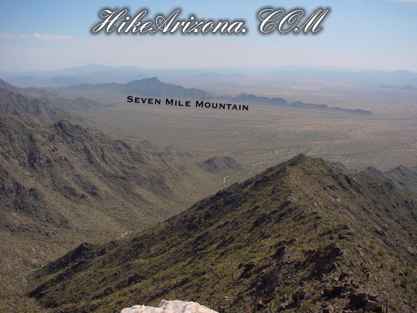
The BLM says the final quarter-mile is a scramble to the peak. I'd say it's more like the final half-mile. It's nothing difficult to figure out, but it does slow your pace. The trail was well cairned on this outing. I enjoyed the upper sections, where views can be seen going down both sides of the ridge. That's what I call hiking! The final ascent to the peak is steep. The white quartz boulders feel cool and are nice to relax on. As I said, I like this trail. I like it for the workout and peacefulness. The views from the top... well, they kind of bite. You won't get a good look at Phoenix cause it's too far away. I could barely make out Ahwatukee aside South Mountain. The real shocker was how tiny South Mountain looked. Looking to the southwest, you do pick up a great view of Seven Mile Mountain.
Hey, look on the bright side. If you can do this hike twice in a row, you can probably tackle the Grand Canyon to the river. Ew, there's encouragement. I probably won't be back because it's a long drive from home. On the other hand, it's worthy if you haven't done it in my opinion.
Phoenix - Lower Sonoran BLM Division Details GENERAL INFORMATION: Quartz Peak Trail, in the 14,400-acre Sierra Estrella Wilderness, leads visitors from the floor of Rainbow Valley (elevation 1,550 feet) to the summit ridge of the Sierra Estrella at Quartz Peak (elevation 4,052 feet) in just 3 miles. Along the way, visitors are treated to a variety of Sonoran Desert plants and wildlife, scenic vistas, and evidence of the area's volcanic history. The views from the summit are spectacular--to the west is a dramatic panorama of rugged mountain ranges and desert plains, and to the east metropolitan Phoenix unfolds over the valley of the lower Salt River.
Quartz Peak Trail is extremely steep and difficult to follow in places. This is a hike for experienced and well-conditioned hikers only! The trail begins at Quartz Peak Trailhead by following a closed four-wheel-drive track approximately 1/4 mile. Look to the left as you walk up the old road and see a narrow trail ascending the ridge to the north (see map below). The trail is poorly marked in places and does not extend to the summit--the final 1/4 mile to Quartz Peak is a scramble over boulder and talus slopes that requires careful footing. Quartz Peak is a point on the spine of the Sierra Estrella capped with an outcrop of white quartz.
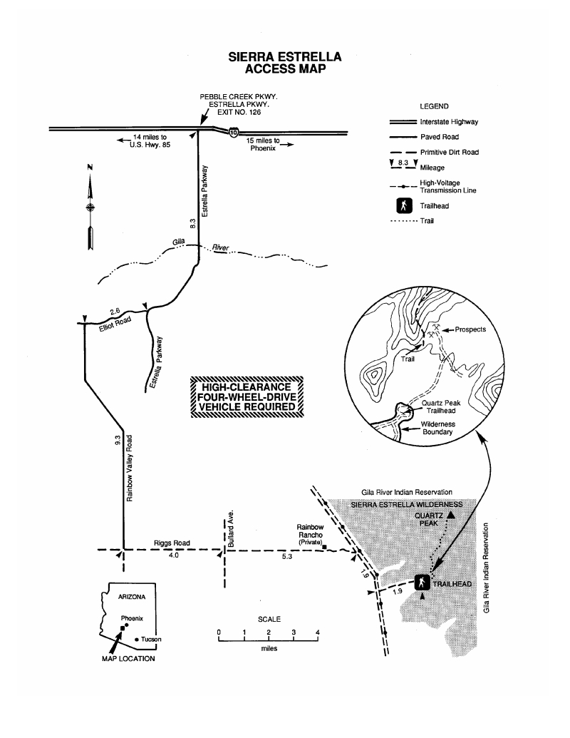
ACCESS: Quartz Peak is accessed from Rainbow Valley and Riggs Roads in Rainbow Valley, approximately 25 miles southwest of Phoenix. See the map below for mileages and directions.
FACILITIES: There are no facilities at Quartz Peak Trailhead.
MAPS: Quartz Peak Trail is not mapped, but the route is covered by USGS 7.5-minute topographic map "Montezuma Peak, Ariz." The Sierra Estrella Wilderness is covered by the USGS 7.5-minute topographic maps "Mobile, NE Ariz." and Montezuma Peak, Ariz."
NOTES:
Quartz Peak Trail receives very little use and the terrain is extremely rugged and remote. Always tell a friend or relative where you are going and when you plan to return.
Drinking water is not provided at Table Top Trailhead, so bring plenty.
The Sierra Estrella and surrounding area is prone to heavy rains and flash floods. Do not attempt to cross flooded washes.
You may encounter rattlesnakes or other poisonous creatures; watch for them and be careful where you put your hands and feet. Do not harass reptiles ? most bites result from people playing with, collecting or attempting to kill them.
Fires are not allowed in the Sierra Estrella Wilderness.
Due to the extremely rugged nature of the Sierra Estrella, horses and packstock are not allowed on Quartz Peak Trail.
WARNING! Hiking and outdoor related sports can be dangerous. Be responsible and prepare for the trip. Study the area you are entering and plan accordingly. Dress for the current and unexpected weather changes. Take plenty of water. Never go alone. Make an itinerary with your plan(s), route(s), destination(s) and expected return time. Give your itinerary to trusted family and/or friends.
Permit $$
None
Directions
Road
High Clearance possible when dry
To Quartz Trailhead North GPS Driving Directions North & West Valley Access by @sarichter
To get to the Quartz Peak Trailhead drive west out of Phoenix on I-10 to the Pebble Creek Parkway/Estrella Parkway exit (#126). Take the Estrella Parkway south 8.3 miles to the intersection with Elliot Road. Turn right on Elliot and drive 2.6 miles to the left branching Rainbow Valley Road. Turn left and follow Rainbow Valley Road 9.3 miles to the signed junction with the dirt Riggs Road (about 1/2 mile past the Cotton Citrus Feed store). Turn left (east) onto Riggs and continue on Riggs 4 miles to a 4-way junction with an unsigned road (listed as Buzzard Rd on the BLM map). Continue straight at this junction (still on Riggs) following the phone lines on your right. After an additional 5.3 miles (along the way passing Rainbow Rancho - which has some airplanes, hangers, and a mortar launcher in the front yard, you will arrive at a 'T' junction with a road running parallel to some large high tension lines. Follow the small trail sign and turn right. Drive 1.9 miles further to a left branching road with another 'trail' sign and arrow (this left turn leads to the Quartz Peak Trailhead). Continue straight for another 1.2 miles and turn left. Follow this somewhat rougher dirt road 2.4 miles and turn left again. Follow an even rougher and rockier road about a mile and park.
Southern Access by @hikeaz
All mileages are taken from my trip-meter, and are approximate.
1) From I-10 & Maricopa Road, take Maricopa Road south approx 14 miles to the intersection with Hwy 238 (soon after mile marker 175)
2) Turn right (west) on Hwy 238 and drive approx 9 miles to mile marker 35. A cattle guard crosses the road exactly at mile marker 35, and immediately past the cattle guard on the right side of the road is an unsigned dirt road with a wire gate.
3) Turn right at this unsigned dirt road at mile-marker 35. (At this point you are at the far (south)end of the road that will take you to the Quartz Peak trailhead road about 9.1 miles away according to the tripmeter)
You may need to have a 4WD vehicle for the first 4 miles or so on this road to be safe . The road is mostly friendly to just about any vehicle, but there is one hill near the beginning and a few deep washes after that for which you should have good clearance and 4WD (in case).
4) So, you follow the high tension line towers for approx 9.1 miles from Hwy 238 (passing thru another wire gate after about 3.4 miles).
Note: There are many unsigned turnoffs along this road, including quite a few in the vicinity of the Quartz Peak trailhead turnoff, so it's important to note that the Quartz Peak turnoff will be almost directly underneath one of the high tension line towers (I think we actually had to pass under the guy wires of the tower at the turnoff), and there should be a small "trail" sign at the turnoff as well (although it may be facing north)
5) Turn right at the Quartz Peak trailhead road and follow it 1.9 miles to the trailhead.
Simplified Southern Access by @rwstorm
A better approach from the South versus the traditional turnoff from Highway 238 at mile marker 35, is to continue on for another mile or two on 238 and turn off at 91st Avenue and work your way around the Waste Management Landfill and Mobile Airport. Then continue north and intersect with the traditional drive in road, bypassing the steep hill, deep wash crossings, and wire gates. Much easier and only adds a few miles to the drive. Here is the gps drive route I put together in 2014 for this: South GPS Driving Directions
From PHX (I-10 & AZ-51) 56.0 mi - about 1 hour 42 mins From TUC (Jct 1-10 & Grant) 127 mi - about 2 hours 38 mins From FLG (Jct I-17 & I-40) 186 mi - about 3 hours 37 mins
 Route Editor

 Quartz Peak Trail is your only legal non-permit ticket to a view on the Estrella ridge. It's a hardy continuous push to the white-capped peak. Judging by the trail log entries, "bites" describes it best. The trail starts as an old jeep route to a mine. In a short quarter-mile, the double tracks go away, and the ascent begins. You'll be ascending a spur ridge (whatever that's called) up to the real ridge. The views are distant. Although I was only thirty miles from home, I couldn't name a mountain without a map.
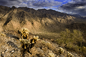


