username
X
password
register
for free!
help
ArticlesGuidesRoutes
 
Photosets
 
 Comments
triplogs   photosets   labels comments more
Table Top Trail - 43 members in 103 triplogs have rated this an average 3.8 ( 1 to 5 best )
1, 2, 3, 4, 5, 6  Next
103 triplogs
login for filter options
Jan 26 2025
avatar

 Guides 1
 Routes 209
 Photos 1,231
 Triplogs 196

male
 Joined Mar 14 2015
 Phoenix, AZ
Table Top TrailSouthwest, AZ
Southwest, AZ
Hiking avatar Jan 26 2025
astrobrewerTriplogs 196
Hiking9.45 Miles 2,479 AEG
Hiking9.45 Miles   5 Hrs   17 Mns   2.00 mph
2,479 ft AEG      33 Mns Break
 
Linked   none no linked trail guides
Partners none no partners
Route Scout Route Recorded  on Route Scout | Pop | Map | Popup | MapDEX
Only my second time on this trail. I really enjoyed Table Top when I hiked it in 2017 and have been looking forward to doing it again every since.

The long dirt road to the trailhead was in decent shape. My Cherokee had no problems. High ground clearance vehicle is strongly recommended. There is one sandy spot about 5 or 6 miles in from I-8 that made me a little nervous, but otherwise no problems. Google maps said that the speed limit on the dirt road is 55mph, but I drove a lot slower than that.

The pit toilet door doesn't close all the way, but at least it wasn't stinky. Not much tp, so bring your own.

There was a car with a camper trailer in the campground, but we didn't see it hear any people.

If was sunny with a cool breeze. As we climbed the 50 it so switchbacks the wind got strong and cold. Unfortunately it was a bit hazy. Could barely make out Picacho Peak, and couldn't see Four Peaks at all. Bummer. But the view of the nearby dessert was still gorgeous.

On the way down saw a little snake. He was right on the side of the trail. The first two in our group walked right past him. He waited for me to snap a couple of pictures then took off. Saw some quail and a couple of lizards too.

When we got back to the sign in log we saw that we were the only ones to sign in that day. We had the whole mountain to ourselves. It was great.
 Culture
 Culture [ checklist ]
[ checklist ]  Benchmark
_____________________
 
Dec 31 2024
avatar

 Routes 30
 Photos 893
 Triplogs 28

male
 Joined Oct 14 2021
 Tucson, AZ
Table Top TrailSouthwest, AZ
Southwest, AZ
Hiking avatar Dec 31 2024
BubbaJuiceTriplogs 28
Hiking9.44 Miles 2,457 AEG
Hiking9.44 Miles   5 Hrs   33 Mns   1.92 mph
2,457 ft AEG      38 Mns Break
 
1st trip
Linked   none no linked trail guides
Partners none no partners
The drive was not that bad with fwd 8 inches of clearance. We were the only ones at the trailhead except for some campers who were gone by the time we got back. The bathroom doesn't have toilet paper or hand sanitizer but somehow didn't stink. The trail was pretty flat to the old trailhead and to mile 2. There was no breeze so the 50 degree heat was draining. From there the trail goes up a slope and starts switchbacking and a relieving breeze joined us. It is notable how consistent the grade is with the switchbacks, very impressive and consistently tiring. There was an odd rock wall that was when the switchbacks end and the trail ascends the slope to the south summit. Very quickly the views started appearing all around us and was pretty cool. From here the trail was obviously less maintained but nonetheless very defined. The slope of the mountain was also pretty unique.

Before the true summit we found reference mark 2 (1960) which was an "eccentric" mark to see other benchmarks that were blocked by the flatness of the mountain. The main benchmark (1910) was apart of the Coastal and Geodetic Survey's initial triangulation across Arizona which took azimuths (directions) to other benchmarks in the network to calculate their individual positions. From TABLE, the original survey took measurements towards WHITE TANK, SUPERSTITION, CATALINA, and MARICOPA all of which have been destroyed at some point. There was a bunch of ocotillo blocking the views. We found the cross reference and 1936 reference mark.

On the way down right after the summit there was an overlook where we found a car battery and a steep slope that allowed for some scenic photos and views. Going down the rock was a bit loose at first but nothing thoughtful foot placement couldn't avoid. I was going pretty fast downhill but my hiking partner wasn't. I didn't take long until we were back we just had to get through the mileage.
_____________________
Check out my benchmarks website :D : https://bubbajuice.github.io/benchmarks WIP!
 
Feb 28 2024
avatar

 Guides 59
 Routes 1,100
 Photos 1,191
 Triplogs 1,290

male
 Joined Jan 01 2023
 Arizona
Table Top TrailSouthwest, AZ
Southwest, AZ
Hiking avatar Feb 28 2024
pseudalpineTriplogs 1,290
Hiking9.24 Miles 2,410 AEG
Hiking9.24 Miles   3 Hrs   18 Mns   2.95 mph
2,410 ft AEG      10 Mns Break
 no routesno photosets
1st trip
Linked   none no linked trail guides
Partners none no partners
  1 archive
Jan 20 2024
avatar

 Routes 9
 Photos 490
 Triplogs 20

female
 Joined May 20 2016
 AZ
Table Top TrailSouthwest, AZ
Southwest, AZ
Hiking avatar Jan 20 2024
WildForAZTriplogs 20
Hiking9.19 Miles 2,384 AEG
Hiking9.19 Miles   5 Hrs   15 Mns   1.75 mph
2,384 ft AEG
 
1st trip
Linked   none no linked trail guides
Partners none no partners
Headed out to another southern volcanic wilderness area. After a challenging off-trail hike to the summit of Woolsey Peak last month, today's hike up Table Top seemed luxurious :lol:

Saw about ten wild horses within the first mile of the hike :)

The desert is gorgeous here, with plenty of saguaros, chollas & ocotillos. The silence was incredible. Four small planes passing by at different times made the only sounds for the entire day (other than the horses walking away from me and the wind on top of the peak).

After reaching the top, I headed across to the survey markers. The summit log was next to the Table benchmark, and the older of two notebooks inside began in 2003. The last signature was from New Year's Eve of 2023.

The views were nice, but not optimal due to smog and cloud cover. The wind was a bit chilly at the top. A nice trail swings around the eastern edge of the top to get to the northern side, and the trail is lined with rocks at times.

The driving route is high clearance, and currently easily done with 2WD. One section was washed out pretty deep on one side, but I was able to hug the other side of the road and squeeze around it. I think the drive would be a nightmare if it wasn't dry.

Had the entire wilderness to myself, which surprised me on a Saturday of cloudy, perfect weather.

It was a very enjoyable day here.
 Fauna
 Fauna [ checklist ]
[ checklist ]  Wild horse
 Geology
 Geology [ checklist ]
[ checklist ]  Basalt
_____________________
  2 archives
Jan 06 2024
avatar

 Guides 17
 Routes 297
 Photos 1,808
 Triplogs 276

female
 Joined Mar 11 2002
 Gilbert, AZ
Table Top TrailSouthwest, AZ
Southwest, AZ
Hiking avatar Jan 06 2024
VashtiTriplogs 276
Hiking9.69 Miles 2,444 AEG
Hiking9.69 Miles   5 Hrs   54 Mns   1.85 mph
2,444 ft AEG      40 Mns Break
 
1st trip
Linked   none no linked trail guides
Partners none no partners
Route Scout Route Recorded  on Route Scout | Pop | Map | Popup | MapDEX
First trip out to table Top! It's been on my list for a while, and I was finally able to make it happen today!

Long drive from Gilbert, but the spectacular diversity and sheer amount of cacti made it worth it! It was glorious to hike through so many different types of cacti, and so very many of them! The saguaros are my favorites, but some ocotillo were starting to leaf out, and the cholla were glowing in the late afternoon sun. There are also some great views from the top, as well as along the way.

Table top is a remote location, and we didn't see anyone else driving in until we reached the Trailhead where there seemed to be a party! A big group was camping, and sadly two parties were in an aggressive argument over moving their vehicles in the parking lot (!). The lot itself was bigger than I thought it would be, and full! I was happy and surprised to see a pit toilet.

The road itself wasn't too bad. I never had to put my Cherokee into 4wd. That being said, I would not bring a sedan on this road with the many washes and some sandy areas. You would know not to bring a passenger car though, as there were multiple signs about how the road is not maintained and how a 4wd is recommended, high clearance is required. There was also an interesting sign about smuggling and illegal immigration. I've never seen a sign like that before.

The trail itself was great. Easy to follow. I wish I had brought some pruning shears to cut back some pokey shrubs encroaching on the trail, but even without them, the trail wasn't too bad. We enjoyed all the different rocks on this trail, too, from beautiful quartz to various colors of lava rock. Someone made an impressive wall of basalt nearer to the top after the steeper switchbacks end.

We were almost last to start up for the day, and we had the trail to ourselves up until the last mile to the top when we met everyone coming down in a pretty big group. As a result, we also had the summit to ourselves which was nice. After a leisurely hike down, we arrived back to an empty Trailhead. We had an uneventful drive out (no smugglers in sight!), and we were treated to an amazing sunset on our way out of Maricopa.

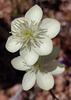
We saw one lone flower the entire hike,and I'm not sure what type of plant it is. 🌿😊
_____________________
:D
 
Mar 12 2023
avatar

 Guides 104
 Routes 256
 Photos 16,118
 Triplogs 528

53 male
 Joined Dec 30 2005
 Tucson, AZ
Table Top TrailSouthwest, AZ
Southwest, AZ
Hiking avatar Mar 12 2023
Mike_WTriplogs 528
Hiking10.50 Miles 2,538 AEG
Hiking10.50 Miles   5 Hrs   30 Mns   1.91 mph
2,538 ft AEG
 no routes
1st trip
Linked   none no linked trail guides
Partners none no partners
Hiked with Brian and Tim starting at around 10:20 am. The drive on the dirt road was better than I expected based on what I've heard and it ended up being about a total of 15 miles on dirt road. I didn't have to put the truck into 4 wheel drive once. So, high clearance was all that was needed today, but the road was dry. If the road happens to be wet, you may need 4 wheel drive to get to the trailhead. At the trailhead, there was nobody else there on a Sunday morning. We started hiking and the trail was in great shape and easy to follow. From a distance it was difficult to see which way the trail went up the mountain. The trail was a bit rocky in some places, with a lot of lava rock, and there weren't any dangerous or exposed areas the entire way. Once we reached what we thought was the top, we realized we still had roughly 1/2 mile to go. The true summit was 15 feet taller on the Northern side. We saw at least 3 different solar panel / antenna systems up there are wondered what they were all used for and why there were several. The peak had a lot of prickly pear, yucca, ocotillo, some agave, and of course a lot of lava rock. At the peak, we saw a few turkey vultures circling around the area to our West. We saw one land near the edge of the peak and then take off again. Maybe there was a nest in that area. All in all it was a great hike, fairly easy because of the well-maintained trail. We also learned it was a P2K hike with 2000 feet of prominence. We'd like to go back in a few weeks and hike the nearby Antelope peak, which we believe is a shorter hike, but a complete bushwhack, as far as we could tell.
_____________________
Michael Williams
IT Professional
Rocky Point Vacation Rentals
Ocean Front Condo in Rocky Point, Sonora, Mexico
www.beachfrontmexico.us
Image
 
Feb 27 2023
avatar

 Guides 110
 Routes 2,246
 Photos 8,982
 Triplogs 2,600

45 female
 Joined Dec 24 2007
 Ahwatukee, AZ
Table Top TrailSouthwest, AZ
Southwest, AZ
Hiking avatar Feb 27 2023
LindaAnnTriplogs 2,600
Hiking9.19 Miles 2,400 AEG
Hiking9.19 Miles   4 Hrs   51 Mns   2.01 mph
2,400 ft AEG      17 Mns Break
 
Linked   none no linked trail guides
Partners partners
gummo
Route Scout Route Recorded  on Route Scout | Pop | Map | Popup | MapDEX
I thought it might be fun to pinstripe a brand new truck today. The road in is in fairly good condition, most of the rocks are gone, but has some sandy spots. Some vegetation encroaching on the sides.

Scott and I were pleasantly surprised that the 31 degree temp at the start didn’t feel cold at all. Headed uphill. Saw a helicopter land at the helipad up top, then take off again. Some vegetation to dodge along the trail, mostly palo verde, but overall the trail is in decent shape. Rocky as usual just before you top out on the west side.

At the top, there were some Border Patrol agents (dropped off from the helicopter) fixing a repeater they had set up last week. They seemed eager to chat, so we talked for a few minutes before continuing over to the summit. Quick stop at the summit, then retraced our steps back across the top. Watched the helicopter land again, and said our goodbyes to the agents as they were getting ready to leave.

The descent seemed rockier than the ascent, but was uneventful. Crossed paths with one couple about a mile or so from the trailhead. Warming up by the finish, but the breeze felt good. Nice to hike with Scott again, and always good to visit Table Top.
wildflower observationwildflower observationwildflower observationwildflower observationwildflower observation
Wildflowers Observation Isolated
Flowers just starting.
_____________________
Stop crying and just go do the hike.
 
Dec 16 2022
avatar

 Guides 8
 Routes 70
 Photos 3,208
 Triplogs 273

59 male
 Joined Oct 07 2017
 Chandler, AZ
Table Top TrailSouthwest, AZ
Southwest, AZ
Hiking avatar Dec 16 2022
YoderTriplogs 273
Hiking9.40 Miles 2,384 AEG
Hiking9.40 Miles   4 Hrs   30 Mns   2.47 mph
2,384 ft AEG      42 Mns Break10 LBS Pack
 no routes
Linked   none no linked trail guides
Partners none no partners
We hadn't done this hike for a while, so we thought we would go back to it. It is quite a nice hike and the trail is easy to follow. Views are great as you are going up the mountain, and when you are on top.

The drive out there isn't very fun though.
 Fauna
 Fauna [ checklist ]
[ checklist ]  Bighorn Sheep
_____________________
J. Yoder
 
Nov 06 2022
avatar

 Guides 10
 Routes 673
 Photos 7,281
 Triplogs 4,660

67 female
 Joined Nov 17 2008
 phoenix, az
Table Top TrailSouthwest, AZ
Southwest, AZ
Hiking avatar Nov 06 2022
trekkin_geckoTriplogs 4,660
Hiking9.07 Miles 2,384 AEG
Hiking9.07 Miles   3 Hrs   45 Mns   2.53 mph
2,384 ft AEG      10 Mns Break
 
Linked   none no linked trail guides
Partners partners
chumley
plan b for the day, with an excellent suggestion by chums to hike table top
45 degrees on the drive in but felt warmer with no wind, especially once we started the uphill
the steeper switchback section is always a good challenge
i was just trying to stay close :sweat:
nice up top with great views and an easy final half mile to the summit
we wandered around for a few minutes, checking out the relay station and the benchmark
the switchbacks down seemed to have better footing on loose rock than i remember
the return went quickly and we finished up with temps in the low 70s
saw one other hiker
love the desert out there
the road in seemed a little more washed out this time
thanks for driving, todd
enjoyed hiking with you again
_____________________
hazhole
 
Nov 06 2022
avatar

 Guides 94
 Routes 840
 Photos 22,055
 Triplogs 1,993

52 male
 Joined Sep 18 2002
 Tempe, AZ
Table Top TrailSouthwest, AZ
Southwest, AZ
Hiking avatar Nov 06 2022
chumleyTriplogs 1,993
Hiking9.31 Miles 2,475 AEG
Hiking9.31 Miles   3 Hrs   45 Mns   2.48 mph
2,475 ft AEG
 
Linked   none no linked trail guides
Partners partners
trekkin_gecko
This was a last minute decision after another hike option fell through. It's a solid hike in beautiful desert terrain, not too far from town and allows for a half-day commitment. Kelly was able to come along, which made for some nice company and conversation along the way.

There were a few wash crossings on the road in that might pose a problem for those who typically find such things to be problematic. Summer flooding has cut some deeper channels resulting in approach and departure angles playing a factor for some users.

There was jeep at the trailhead and we found the owner about halfway up the trail. He seemed curiously out of place.

The weather was perfect, a little chilly to start but once moving uphill no problem. The antenna when initially reaching the tabletop isn't there anymore, but a new one now stands at the north end of the peak.

Only found one of the reference marks. Can't remember if the other was ever there, and for some reason, the search for datasheets on the USGS website isn't working for me the past few tries, so I wasn't able to figure out which direction and distance to look for it.

Views were a bit hazy with dust in the air, but still nice views including Four Peaks, Saddle Mtn, Babo, Lemmon, Turnbull, and the Supes. A great day out in the monument. :)
_____________________
I'm not sure what my spirit animal is, but I'm confident it has rabies.
 
Jan 22 2022
avatar

 Guides 12
 Routes 192
 Photos 863
 Triplogs 356

42 male
 Joined Nov 30 2015
 Phoenix, AZ
Table Top TrailSouthwest, AZ
Southwest, AZ
Run/Jog avatar Jan 22 2022
ShatteredArmTriplogs 356
Run/Jog9.07 Miles 2,384 AEG
Run/Jog9.07 Miles   2 Hrs   50 Mns   3.40 mph
2,384 ft AEG      10 Mns Break
 no routesno photosets
1st trip
Linked   none no linked trail guides
Partners none no partners
Wanted an easier route today, so headed down to Table Top, which I have always wanted to check out for some reason. Fun drive through the Vekol Valley to get to the TH.

Nice desert vegetation in the lower elevations. The climb up the mountain seemed a little relentless, but it was nice once on top. Wandered over to the summit, then back. Good amount of cacti up there.

Jogged most of the way down, but it was pretty chunky on the side of the mountain, so couldn't really get a good stride until the flat part.

Didn't see anybody on the trail, but saw a lot more people than I expected in the valley.
_____________________
 
Jan 18 2022
avatar

 Guides 7
 Routes 79
 Photos 2,440
 Triplogs 652

34 male
 Joined Jan 10 2010
 Pomona, CA
Table Top TrailSouthwest, AZ
Southwest, AZ
Hiking avatar Jan 18 2022
PatrickLTriplogs 652
Hiking9.40 Miles 2,480 AEG
Hiking9.40 Miles   4 Hrs   35 Mns   2.21 mph
2,480 ft AEG      20 Mns Break12 LBS Pack
 no routes
1st trip
Linked   none no linked trail guides
Partners none no partners
Finally got around to this one and it did not disappoint. The 30% chance of rain made for a classic desert day with puffy clouds and shade. It sprinkled briefly on the drive in but that was all.

The road is much better than I anticipated - lots of dips and a little sand. I kept waiting for it to worsen and it never did. IMO, the road to Quartz is worse.

The trail was pretty good but it’s becoming a little overgrown in spots, mostly palo verde branches and rogue ocotillo stalks. I loved the Sonoran scenery with Table looming overhead the whole time. It’s like AZ’s miniature Kilimanjaro. Views up top were great in all directions. Visibility was just okay as I couldn’t make out the White Tanks to the north. The Catalinas seemed shrouded as well.
Super happy about this one. What a great day!
 Culture
 Culture [ checklist ]
[ checklist ]  Benchmark  Fliver
_____________________
 
Feb 20 2021
avatar

 Guides 4
 Routes 491
 Photos 10,890
 Triplogs 1,257

55 male
 Joined Nov 20 2012
 Phoenix, AZ
Table Top TrailSouthwest, AZ
Southwest, AZ
Hiking avatar Feb 20 2021
BiFrostTriplogs 1,257
Hiking9.62 Miles 2,384 AEG
Hiking9.62 Miles   5 Hrs   6 Mns   2.14 mph
2,384 ft AEG      36 Mns Break
 no routes
1st trip
Linked   none no linked trail guides
Partners partners
slowandsteady
We were looking for a new desert peak to hike and figured giving Table Top a shot. The drive was interesting as I’ve always wondered what was down Vekol Road off I-8. It’s about 15 miles of decent dirt road to the trailhead. When we arrived, there were about 8 off roaders blocking the trailhead and flying drones. Fortunately, there were only interested in the trailhead and we had the trail to ourselves. The first 2 mile is gradual up and a good warm up for the steep ascent at the end. There is a consistent series of switchbacks that leads to the first summit. According to the topo the first summit is 17 feet lower than the second. We continued on to the second summit and had lunch before hiking back down. On the way back down the trail…is that guy naked? Yep there was a naked guy hiking on the trail. Fortunately, it was at a distance and by the time we caught up he managed to put some clothes on. Other than that nice desert stroll back to the trailhead.
_____________________
  1 archive
Jan 02 2021
avatar

 Guides 1
 Routes 447
 Photos 4,407
 Triplogs 938

68 male
 Joined Mar 09 2012
 Gilbert, AZ
Table Top TrailSouthwest, AZ
Southwest, AZ
Hiking avatar Jan 02 2021
rayhustonTriplogs 938
Hiking9.14 Miles 2,382 AEG
Hiking9.14 Miles   4 Hrs   46 Mns   2.27 mph
2,382 ft AEG      44 Mns Break
 no routes
1st trip
Linked   none no linked trail guides
Partners 8 partners
Eaglet
johnlp
JuanJaimeiii
LindaAnn
PrestonSands
The_Eagle
Tortoise_Hiker
trekkin_gecko
These year end hikes with Bruce and Denny haven’t always fared well for me, but this one turned out great.

A little chilly at the start, but we warmed up quickly with a nice, relatively flat two mile power walk before the steep switchbacks began. Then most started shedding layers.

The views along the way were splendid. Although dry out here like everywhere, this area looked better than most I’ve seen recently. It must look amazing with a fair amount of rainfall.

I had the good fortune of hiking with @PrestonSands for the first time. Nice to meet you Preston! Nice seeing the rest of the gang again!

The road was in pretty good shape according to those that have been here before. No problem driving in but I hit a sandy rut a little too quickly and bottomed out once on the way back. No harm done.

Great day, great company, good times!
 Flora
 Flora [ checklist ]
[ checklist ]  Soaptree Yucca
 Named place
 Named place [ checklist ]
[ checklist ]  Table Top 4373
_____________________
  1 archive
Jan 02 2021
avatar

 Guides 10
 Routes 673
 Photos 7,281
 Triplogs 4,660

67 female
 Joined Nov 17 2008
 phoenix, az
Table Top TrailSouthwest, AZ
Southwest, AZ
Hiking avatar Jan 02 2021
trekkin_geckoTriplogs 4,660
Hiking9.14 Miles 2,382 AEG
Hiking9.14 Miles   4 Hrs   46 Mns   2.27 mph
2,382 ft AEG      44 Mns Break
 
Linked   none no linked trail guides
Partners 8 partners
Eaglet
johnlp
JuanJaimeiii
LindaAnn
PrestonSands
rayhuston
The_Eagle
Tortoise_Hiker
bruce and denny's new year's hike this year featured table top
third one of these i've been on
always fun with a good group of haz members
nice to meet preston for the first time
table top is a nice peak - my second time up
flat warm up, then some moderate uphill, then some steep uphill
after topping out, the trail curves around to the high point another half mile or so away
good views on the entire hike with interesting desert terrain
cool temps to start with, but warmed up on the ascent and then perfect conditions on the return
snacked and took photos at the summit
thanks to linda, ray and jj for driving, and thanks to bruce and denny for the invite
good hike to start off 2021
_____________________
hazhole
 
Jan 02 2021
avatar

 Guides 110
 Routes 2,246
 Photos 8,982
 Triplogs 2,600

45 female
 Joined Dec 24 2007
 Ahwatukee, AZ
Table Top TrailSouthwest, AZ
Southwest, AZ
Hiking avatar Jan 02 2021
LindaAnnTriplogs 2,600
Hiking8.86 Miles 2,379 AEG
Hiking8.86 Miles   4 Hrs   46 Mns   2.31 mph
2,379 ft AEG      56 Mns Break
 
Linked   none no linked trail guides
Partners 8 partners
Eaglet
johnlp
JuanJaimeiii
PrestonSands
rayhuston
The_Eagle
Tortoise_Hiker
trekkin_gecko
Route Scout Route Recorded  on Route Scout | Pop | Map | Popup | MapDEX
The road on the drive in is in good shape. Medium clearance is fine. Vekol Rd has some sandy spots that might require AWD or better but I had enough momentum to cross the largest sandy section in 2WD. The road heading east (8024?) is in the best shape I’ve ever seen—the large rocks are gone and the brush has been trimmed back.

Got started around 0800. Cold to start, but we kept a pace that had us warm within the first half mile. I always like this hike, the first couple miles are a nice gradual warmup, then the steep climb, followed by an easy walk across the top to get to the highpoint. Great views in all directions, although it was hazy today. Easy hike back down, with some loose rock in a few places.

Fun group, great conversation, and nice to meet Preston and Ben. Thank you to Bruce and Denny for the invitation.
_____________________
Stop crying and just go do the hike.
 
Jan 02 2021
avatar

 Guides 41
 Routes 1,626
 Photos 14,983
 Triplogs 2,760

69 male
 Joined Jan 20 2009
 Far NE Phoenix,
Table Top TrailSouthwest, AZ
Southwest, AZ
Hiking avatar Jan 02 2021
The_EagleTriplogs 2,760
Hiking9.61 Miles 2,419 AEG
Hiking9.61 Miles   4 Hrs   46 Mns   2.39 mph
2,419 ft AEG      45 Mns Break12 LBS Pack
 
1st trip
Linked   none no linked trail guides
Partners 8 partners
Eaglet
johnlp
JuanJaimeiii
LindaAnn
PrestonSands
rayhuston
Tortoise_Hiker
trekkin_gecko
Route Scout Route Recorded  on Route Scout | Pop | Map | Popup | MapDEX
The 10th annual New Years Eve-ish hike for Denny and myself. This years goal was Table Top Mountain, which was a first time for me. The thermometer on JJ's jeep had us a bit scared on the way in, getting as low as 19, before settling at 40 at the TH at 8am. He was more sane then normal on the drive in.

After exchanging pleasantries at the TH, it was time to get moving, to take the chill off. I like the way this one starts off gradual to let you warm up before the steepness begins. There are great views all around on the climb up. It gets a bit steep approaching the first peak. The speedsters waited at the first peak for the rest of us to gather, before we headed off to to the high point.

At the second peak we had a break/lunch/snacks before taking the obligatory group shot. As we were leaving the peak, a group of four was approaching.

I really enjoyed this hike. Alway great catching up with the cast of characters from the Island of Misfit Toys. It's a treat hiking with my son Ben. Preston, thanks for joining us for your first time. John, John, Linda, Ray, Kelly, thanks for coming along again. Denny, another successful get together. Don't be a stranger. All, Hopefully we can get together more than once this coming year. Happy New Year all!

The drive out with JJ, was more JJ like :o He had places to be. Thanks? for driving :scared:
 Culture
 Culture [ checklist ]
[ checklist ]  Benchmark
_____________________
There is a very fine line between "hobby" and "mental illness."
Dave Barry 🦅
  2 archives
Jan 02 2021
avatar

 Routes 596
 Photos 9,604
 Triplogs 2,400

58 male
 Joined Jan 30 2011
 Chandler, AZ
Table Top TrailSouthwest, AZ
Southwest, AZ
Hiking avatar Jan 02 2021
JuanJaimeiiiTriplogs 2,400
Hiking9.14 Miles 2,382 AEG
Hiking9.14 Miles   4 Hrs   46 Mns   2.27 mph
2,382 ft AEG      44 Mns Break
 
Linked   none no linked trail guides
Partners 8 partners
Eaglet
johnlp
LindaAnn
PrestonSands
rayhuston
The_Eagle
Tortoise_Hiker
trekkin_gecko
I wasn't a 100% sure I was going to be able to make this one but I am super glad it worked out. Table Top is always a fun one and this trip was no exception. We had a great group and it was great to see Preston even come up from Tucson to join in the festivities. At the start the temperature was about 50 degrees below my preferred hiking weather so I had to break out the wool cap and gloves. As soon as we hit some sunlight and got the blood pumping I was fine.

Up top we noticed that the old communication device that was once there is now gone. I also noticed that the helipad that was on the northern portion is no longer well marked and easily to see.

A big thanks to Denny for bringing the 2021 glasses for the group photo. Good times with Great people. Happy New Year and thank God that 2020 is behind us.
_____________________
 
Jan 02 2021
avatar

 Guides 1
 Routes 14
 Photos 7,202
 Triplogs 5,208

68 male
 Joined Mar 16 2008
 chandler,az
Table Top TrailSouthwest, AZ
Southwest, AZ
Hiking avatar Jan 02 2021
johnlpTriplogs 5,208
Hiking9.14 Miles 2,382 AEG
Hiking9.14 Miles
2,382 ft AEG
 no routes
Linked   none no linked trail guides
Partners 8 partners
Eaglet
JuanJaimeiii
LindaAnn
PrestonSands
rayhuston
The_Eagle
Tortoise_Hiker
trekkin_gecko
Bruce & Denny's 10th annual New Year's-ish hike. Excellent group but missing a couple HAZ all stars.
Table Top is a great hike. Getting to the trailhead isn't so great, thus it doesn't see a lot of hiking traffic.
Chilly start though we all warmed up once we got going and hiked out of the shade into the sun. Once we started up the mountain slope layers were shed. Beautiful desert along the way with nice long distance views as well.
We took a couple nice breaks up top and celebrated making it to 2021.
Nice to hike with everyone again. Hadn't hiked with Preston since 2012. Cool to meet Bruce's son Ben. I think we may have bored him with our moderate pace.
Thanks Bruce and Denny for organizing and the invite. Thanks Ray, Linda, & JJ for driving. Stay healthy and happy in 2021! :)
_____________________
“Good people drink good beer.” Hunter S Thompson
 
Jan 02 2021
avatar

 Guides 170
 Routes 148
 Photos 5,914
 Triplogs 2,097

48 male
 Joined Apr 12 2004
 Tucson, AZ
Table Top TrailSouthwest, AZ
Southwest, AZ
Hiking avatar Jan 02 2021
PrestonSandsTriplogs 2,097
Hiking9.61 Miles 2,419 AEG
Hiking9.61 Miles   4 Hrs   46 Mns   2.39 mph
2,419 ft AEG      45 Mns Break
 no routes
1st trip
Linked   none no linked trail guides
Partners 8 partners
Eaglet
johnlp
JuanJaimeiii
LindaAnn
rayhuston
The_Eagle
Tortoise_Hiker
trekkin_gecko
I rolled in to the Table Top trailhead just in time to meet everyone in the group. After introductions and throwing some gear in my pack, I hustled up the trail to join them. The winter morning’s chill was quickly chased away as the sun rose higher and my blood started circulating. This was my first time hiking this trail and in this region, and the healthy desert scenery was especially nice. Our group moved steadily up the foothill ridges and onto the steep and rocky mountain slopes, where hazy silhouettes of distant desert ranges were framed by statuesque saguaros.

Concluding a healthy workout on the switchbacks, we regrouped on the mountain top and began the last leg to the northern summit plateau across a basalt and prickly pear covered mesa. Amazing 360 views from up on top. At the true summit we relaxed for a bit before donning 2021 glasses (thanks Denny!) and getting a group photo (thanks Bruce!). Following a steady descent to the trailhead far below, we all headed for home. So very nice to finally meet Ray, Kelly, Linda and Ben, and great to see Denny, Bruce, JJ and John again! Great chatting and catching up with everyone. Had a great time with you all! Thanks so much for organizing this and for the invite. :D
_____________________
"…you never know when a hike might break out" -Jim Gaffigan
  2 archives
average hiking speed 2.23 mph
1, 2, 3, 4, 5, 6  Next

WARNING! Hiking and outdoor related sports can be dangerous. Be responsible and prepare for the trip. Study the area you are entering and plan accordingly. Dress for the current and unexpected weather changes. Take plenty of water. Never go alone. Make an itinerary with your plan(s), route(s), destination(s) and expected return time. Give your itinerary to trusted family and/or friends.

helpcommentissue

end of page marker