|
| | | |
| |
|
| Hiking | 6.85 Miles |
792 AEG |
| | Hiking | 6.85 Miles | 3 Hrs 20 Mns | | 2.19 mph |
| 792 ft AEG | 12 Mns Break | | | |
|
|
| |
| Linked |
|
none
[ show ]
| no linked trail guides |
| Partners |
|
none
[ show ]
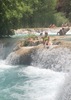
| no partners | | We had no trouble getting to the parking area. As we descended into the canyon, I was thinking of was a nice easy trail, just walking in the forest. But the further we went, the more interesting the trail became. Rock formations on both sides of the canyon were beautiful and fun to explore! We continued to the end of the track, where we could hear ATVers on the nearby forest road. We saw a handful of other hikers and about 10 mountain bikers. Not bad for Labor Day weekend! The wildflowers were on display, which was a fun surprise. The skier was also fun to see!
There were pockets of water with lots of tadpoles, but nothing I would have wanted to drink unless the situation was really dire. |
|
Wildflowers Observation Moderate
Scarlet cinquefoil, Indian paintbrush, daises, spiderwort |
|
| _____________________
| | |
|
|
|
 Route Editor