|
| | | |
| |
|
| Hiking | 7.22 Miles |
1,010 AEG |
| | Hiking | 7.22 Miles | 4 Hrs 33 Mns | | 2.20 mph |
| 1,010 ft AEG | 1 Hour 16 Mns Break | | | |
|
|
| |
| Partners |
|
none
[ show ]
| no partners | | I set out to do a shorter version of the Garwood Trail loop. I took some wrong turns along the way. I had a fine time, but I don't recommend retracing my steps for reasons I'll explain.
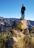
This is my first time hiking in this area. This is a well-used section of the park, and there's quite a network of trails connecting to one another. This isn't like backcountry hiking where you're not sure if you're still on the trail or not. You can't get lost that way. With so many trails here, the challenge is figuring out WHICH trail you should be on. There are parts with five-way intersections, and the NPS signs work differently than the Forest Service signs.
The first thing I realized is that I missed the turn for Garwood Trail and did the loop clockwise instead of counter-clockwise like I intended. There's nothing wrong with this, except the approach of some of the landmarks is a little less dramatic, and heading up the Douglas Springs Trail right away hits you with a bit of elevation gain right off the bat. If you take the right onto Garwood Trail, you'll stay in the cactus forest a bit longer before meeting a more gradual elevation gain.
After slogging up the Douglas Springs Trail, I considered heading to up the Bridal Wreath Falls, but a returning hiker tipped me off there was just a trickle in the falls that day, so I hooked a right onto the Carillo Trail to take the shorter loop I intended.
After hiking down this span of trail a little ways, you come into this weirdly serene valley. It's got a little ridge on one side blocking exposure to the foothills, and another little ridge heading up on the Rincon side. It was completely silent in this valley. No wind or rustling. No birds or insects. It was really strange and if not for the sound of my own feet I'd have worried I went deaf. You can spy some interesting looking canyons here too, all very inviting. (Please don't hike off-trail in Saguaro NP.) After making your way through this quiet zone, the terrain turns into a riparian section, with green grass, although I didn't see an open river. This section comes out over a little wash/canyon which had some water running through it on this day, and downstream from that is the Steel Tank.
The steel tank didn't have any water in in this day, but it's always pretty neat stumbling across a big manmade structure in the wilderness. It's here I made my next mis-step. I hooked a right and followed a few other hikers west down the prominent Three Tank Trail. Except, the trail that goes to Garwood Dam is the Carillo Trail, which is south of the tank and a little harder to spot.
Oh well. The Three Tank Trail is still a nice hike, with good vistas that overlook deep canyons and dropoffs, and at this point you're gently losing elevation. The next junction, for Wildhorse Trail, was particularly scenic, but I also failed to realize that was the next best route to Garwood Dam.
My phone (recording the GPS track) was running low on battery, but I was feeling pretty confident about the time I'm making as I decend back into the cactus forest, when I come to one of those 5-way intersections. This warrants pulling out my device to realize I completely missed the highlight of the hike, Garwood Dam!
So now my loop has gained an extra out-and-back spur down Garwood Trail. It's easy hiking... did I mention this trail system is shared with horses? So in addition to the usual challenges of putting your feet on stable ground and not putting your feet into sharp plants, there's a bonus challenge of not putting your feet on horse presents, which sometimes takes a little extra footwork. Anyway, this section of trail is easy except for jumping over not a few horse bombs. There's a particularly beautiful crested cactus along this span too, right at Bajada Wash.
You hook a right a the fork and follow that until it overlooks Wild Horse Canyon, and there it is up the canyon, the Garwood Dam. It predates this place's status as a National Park and it's not the hugest thing in the world but it's pretty impressive when you learn it was built by one guy to provide water to his house! There's this stone and rebar pad overlooking the canyon - this was where the house electrical generator sat - that provides a good viewing point for the dam and the canyon.
I hiked up the trail to the dam. There was some water flowing through the canyon today, although the old reservoir has silted up and turned into a verdant patch of mud, and the dam has holes in it so water runs through and not over. I took a lot of pictures from the outcropping on the near side of the dam, but heeded the posted warning sign about not scrambling across the top of the dam itself. That would be an unfortunate fall.
When I was satisfied at the dam, I backtracked back to the five way intersection. Like, there are actually two junctions, each with their own set of signs. I managed to set off on the wrong trail again before realizing the mistake, backtracking to the junction, and finally heading down the Garwood Trail back to the trailhead. My phone had completely died at this point. |
| _____________________
| | |
|
|
|
 Route Editor