|
| | | |
| |
|
| Canyoneering | 6.00 Miles |
1,000 AEG |
| | Canyoneering | 6.00 Miles | 7 Hrs | | 0.86 mph |
| 1,000 ft AEG | | | | |
|
|
| | Intermediate Canyoneering - Difficult or dangerous; Tech Climb; rope reqd; descent anchor; exit technical; | | B - Up to light current; wading/swimming; possible wet/dry suit | | III - Normally requires most of a day |
| |
| Partners |
|
none
[ show ]
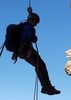
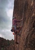
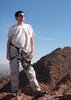
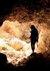
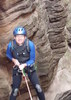
| no partners | | So I didn't fully believe the weather forecast as it slowly decreased the chance of rain on this weekend, so by Sat evening I watching to go hike a wet hike in the Supes and just take my chances.  I couldn't get anyone else interested in this crazy adventure, so I woke up early and made the drive towards Canyon Lake. I was rewarded with sweet views of Flatiron covered in clouds & snow, loads of snow surrounding the Canyon Lake & Tortilla Flat area, and even much more snow as I slowly made the snowy, wet & slippery drive to and down to Fish Creek Canyon. I couldn't get anyone else interested in this crazy adventure, so I woke up early and made the drive towards Canyon Lake. I was rewarded with sweet views of Flatiron covered in clouds & snow, loads of snow surrounding the Canyon Lake & Tortilla Flat area, and even much more snow as I slowly made the snowy, wet & slippery drive to and down to Fish Creek Canyon.  It was so amAZing so see everything above 2500ft covered in at least 2-3 inches of snow. It was so amAZing so see everything above 2500ft covered in at least 2-3 inches of snow.  The approach hike up that ridge out of Fish Creek Canyon was def much slower than usual as I'm battliing the slippery snow, soaking in the sweet views, and taking loads of photos. Even up on the bench of Horse Mesa was rather slow going and I dropped into upper Sierra Canyon and up and over into Tango Canyon. The approach hike up that ridge out of Fish Creek Canyon was def much slower than usual as I'm battliing the slippery snow, soaking in the sweet views, and taking loads of photos. Even up on the bench of Horse Mesa was rather slow going and I dropped into upper Sierra Canyon and up and over into Tango Canyon.  Again, the views up there with it completely covered in snow was so absolutely breathtaking as I watched a wall of rain slam into Superstition Mountain. Upper Tango Canyon is usually dry as a bone but at that confluence the two upper drainage we both flowing rather well. I had to wade a waist high chilly pool to get to the top of the narrows, which were full of chilly deep pools and falls. Hmm, yea... Again, the views up there with it completely covered in snow was so absolutely breathtaking as I watched a wall of rain slam into Superstition Mountain. Upper Tango Canyon is usually dry as a bone but at that confluence the two upper drainage we both flowing rather well. I had to wade a waist high chilly pool to get to the top of the narrows, which were full of chilly deep pools and falls. Hmm, yea...  This is usually a 3A canyon so I didn't have wetsuit with me and instead bypassed the upper narrows and found a side drainage to build an anchor and rappel 40ft back into the main drainage. That usually dry 50ft falls was now flowing very nicely and thankfully I was able to rappel between the many falls and the pool below was only waist high. This is usually a 3A canyon so I didn't have wetsuit with me and instead bypassed the upper narrows and found a side drainage to build an anchor and rappel 40ft back into the main drainage. That usually dry 50ft falls was now flowing very nicely and thankfully I was able to rappel between the many falls and the pool below was only waist high.  Below this falls the canyon opens up with some cool slickrock sections, the water slowly goes underground, its sunny & warm again, and the snow slowly disappeared... Eventually after some light down climbing & falls bypassing you reach the chute with the final 70ft rappel. Seeing that previously falls flowing nicely, I was afraid this lower falls would really be rocking but thankfully it was only lightly flowing. This is by far the sweetest rappel of the canyon and during the 40ft free hanging section I was treated to a refreshing cold shower. Below this falls the canyon opens up with some cool slickrock sections, the water slowly goes underground, its sunny & warm again, and the snow slowly disappeared... Eventually after some light down climbing & falls bypassing you reach the chute with the final 70ft rappel. Seeing that previously falls flowing nicely, I was afraid this lower falls would really be rocking but thankfully it was only lightly flowing. This is by far the sweetest rappel of the canyon and during the 40ft free hanging section I was treated to a refreshing cold shower.  Dropped the gear, did some more rock hopping down to Fish Creek Canyon and was treated to a beautiful sunny warm afternoon for the creek hike back up to the highway. Dropped the gear, did some more rock hopping down to Fish Creek Canyon and was treated to a beautiful sunny warm afternoon for the creek hike back up to the highway. |
| _____________________
| Yea, canyoneering is an extreme sport... EXTREMELY dramatic!!! =p |
| | |
|
|
|
 Route Editor