username
X
password
register
for free!
help
ArticlesGuidesRoutes
 
Photosets
 
 Comments
triplogs   photosets   labels comments more
O'Leary Peak - 27 members in 65 triplogs have rated this an average 3.7 ( 1 to 5 best )
1, 2, 3, 4  Next
65 triplogs
login for filter options
Aug 05 2025
avatar

 Guides 104
 Routes 256
 Photos 16,118
 Triplogs 528

53 male
 Joined Dec 30 2005
 Tucson, AZ
O'Leary PeakFlagstaff, AZ
Flagstaff, AZ
Hiking avatar Aug 05 2025
Mike_WTriplogs 528
Hiking10.57 Miles 2,285 AEG
Hiking10.57 Miles   6 Hrs   43 Mns   2.55 mph
2,285 ft AEG   2 Hrs   34 Mns Break
 no routes
1st trip
Linked   none no linked trail guides
Partners none no partners
Note: my stats involve both the summit and the fire tower nearby.

I've been wanting to do this hike for a couple of years now. Finally, I had a plan to do it. After this hike I finished the AZ 20-20 challenge!

The hike to the fire lookout tower is all well-maintained road. To get to O'leary peak, you will hike about 4.7 miles to the high saddle, then you will ascend a steep slope for the final 700 feet. There is a faint use trail and the terrain is scree-like in that you will take a step and sometimes slide 20-50% backwards! This makes this final part of the climb quite challenging. I found a registry at the top and signed it. There are some great views looking West toward Mt Humphreys and some of the other high peaks. Looking East I could see some of the Sunset Crater Volcano National Monument.

I also went to the fire tower, found a registry there and signed it. I was surprised to learn it's still being used today but there was nobody working the tower on the day I was there. I met a couple from Northern Cali near the tower who ascended after me. We had a nice chat about peaks in Cali, AZ, and Colorado. We hiked together for part of the way down. It was quite hot in the afternoon.

It was nice to see many wildflowers on the higher elevation part of this hike. Something you rarely see in the summer, at least in Southern AZ.

Stats:
---------
10.57 miles round trip
2285 feet AEG
strava moving time 4 hrs 9 mins
strava elapsed time 6 hrs 43 mins

Driving directions
-------------------
** (Any passenger car can make it)
From anywhere in Flagstaff take Historic Rte 66 / Business route 40 EAST
Continue onto N 89 for 12.1 mi
Turn right onto Fire Rd 545/Loop Rd
Continue to follow Loop Rd for 1.8 mi
Turn left onto Forest Service Rd 545A
Continue for 0.35 miles
Do not turn into the group camping area
You will see parking for 7 or 8 cars on the right
_____________________
Michael Williams
IT Professional
Rocky Point Vacation Rentals
Ocean Front Condo in Rocky Point, Sonora, Mexico
www.beachfrontmexico.us
Image
 
May 22 2025
avatar

 Guides 69
 Routes 37
 Photos 3,010
 Triplogs 2,387

55 male
 Joined Oct 24 2010
 Phoenix,Az
O'Leary PeakFlagstaff, AZ
Flagstaff, AZ
Hiking avatar May 22 2025
mt98dewTriplogs 2,387
Hiking10.06 Miles 2,016 AEG
Hiking10.06 Miles   3 Hrs   20 Mns   3.02 mph
2,016 ft AEG
 no routes
1st trip
Linked   none no linked trail guides
Partners none no partners
Belated post. Last day in Flagstaff allowed for one last early morning hike. Love summer for that reason. At the TH a little after 5.00 with the pre-morning light already illuminating the road. I didn’t need too much light, because the trail was a road all the way to the top. You start off flat or even losing some elevation before the trail starts to climb. Pretty gradual for the first 3.6 miles, but at that time you reach a saddle and pass through an open road gate and the road starts ramp up the incline. Views were nice as I was climbing, but I wished I had started earlier so I could catch the “morning blush” of the San Francisco Peaks. Nearing the top, there is a metal track to help vehicles gain traction on the last ascent. Very disappointed in the views. The view to Sunset Crater was ok, but not overly revealing. I had really enjoyed my drive from Sunset to Wupatki the previous day and was looking forward to the southern view from the top of O’Leary. However, the previous day there had been a controlled burn around Mormon Lake and the smoke from the fire had created a haze that blanketed the southern desert. Really unfortunate, because I’m sure that view could be fantastic. There was a vehicle and a (I assume) a Ranger at the lookout, but they are on “duty for visitors” from 8-5pm so I didn’t get chance to climb the tower.

Views weren’t as spectacular as I had hoped, but it was a good hike for wildlife. Saw 6 deer and 3 coyotes :) Encountered 1 trail runner as I headed down :app: and three hikers just as I got back to my vehicle.
_____________________
 
Jan 22 2023
avatar

 Routes 386
 Photos 49
 Triplogs 792

43 female
 Joined Jun 23 2015
 Phoenix, AZ
O'Leary PeakFlagstaff, AZ
Flagstaff, AZ
Hiking avatar Jan 22 2023
emilystardustTriplogs 792
Hiking9.97 Miles 2,112 AEG
Hiking9.97 Miles   6 Hrs   55 Mns   1.65 mph
2,112 ft AEG      53 Mns Break
 
Linked   none no linked trail guides
Partners none no partners
Route Scout Route Recorded  on Route Scout | Pop | Map | Popup | MapDEX
First snowshoeing experience. We set a turnaround time that I didn’t think we’d make due to slowness and tiredness. Very challenging but worth it. One set of tracks ahead of us after we got part way up the switchbacks but it looked like they took a few shortcuts that we did not so made our own track part of the way to the tower. Now to get more comfortable boots for the snowshoes. :)
_____________________
 
Aug 29 2020
avatar

 Guides 17
 Routes 297
 Photos 1,808
 Triplogs 276

female
 Joined Mar 11 2002
 Gilbert, AZ
O'Leary PeakFlagstaff, AZ
Flagstaff, AZ
Hiking avatar Aug 29 2020
VashtiTriplogs 276
Hiking9.39 Miles 2,240 AEG
Hiking9.39 Miles   4 Hrs   52 Mns   2.32 mph
2,240 ft AEG      49 Mns Break
 
no photosets
1st trip
Linked   none no linked trail guides
Partners none no partners
Route Scout Route Recorded  on Route Scout | Pop | Map | Popup | MapDEX
Nice views from the fire look out. Beautiful day for a hike, though I don't much love walking up a road for so many miles!
_____________________
:D
 
Jul 26 2020
avatar

 Routes 8
 Photos 2,243
 Triplogs 204

38 male
 Joined Mar 07 2009
 Colorado Springs
O'Leary PeakFlagstaff, AZ
Flagstaff, AZ
Hiking avatar Jul 26 2020
ultrazonaTriplogs 204
Hiking9.70 Miles 1,996 AEG
Hiking9.70 Miles
1,996 ft AEG
 no routesno photosets
1st trip
Linked   none no linked trail guides
Partners none no partners
_____________________
 
Jul 08 2020
avatar

 Guides 7
 Routes 72
 Photos 14,456
 Triplogs 627

62 female
 Joined Aug 19 2011
 Scottsdale, AZ
OLeary LO and Peak, AZ 
OLeary LO and Peak, AZ
 
Hiking avatar Jul 08 2020
outdoor_loverTriplogs 627
Hiking11.00 Miles 2,225 AEG
Hiking11.00 Miles
2,225 ft AEG
 
1st trip
Linked   linked  
Partners none no partners
2nd Hike of the Day
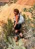
After Picture Canyon, I was waffling on doing this one as it was getting pretty warm. I was worried there wouldn't be enough shade. Turns out there was JUST enough. :sweat:

Didn't start until 11:30 so it was warm enough. The first mile is shaded so I wasn't feeling bad, but after that it was actually probably too warm with the intense sun to boot. But, about every couple of hundred feet or so, there would be a Pine Tree casting shade on the roadway, so it literally became a "shade to shade" hike to the top. If the shade hadn't been there, I think I would have aborted this hike for another time. The Heat and the Uphill took it's toll, but I made it and managed to enjoy the views on the way up. I hit the Peak first, knowing it was the steeper and higher of the two points and that was an interesting ascent. Just enough people have done it to make a slight use trail, but you still sank in and the effort was still there. It was kind of fun coming down as you could almost glissade it, but not quite as good as if you were on pure, very fine cinders.

Then it was over to the Lookout. I knew from Liz's triplog that I couldn't go up, but the Lookout and I exchanged hellos anyway. The Wind had come up and was almost howling at the top so it was difficult for her to hear me. But it was good. I took a small break up there and then started back down. Funny, it didn't seem as hot when you move twice as fast. :sweat: It was also after 4:00 before I headed down. Made good time back to the truck and was certainly ready to be done when I got there. :lol:

In spite of the Heat and the fact that I'm not big on Road Walks, it was a good hike and I felt like I did something. Will I do it again? Maybe, would love to go up in the Tower sometime. :)
wildflower observationwildflower observationwildflower observationwildflower observationwildflower observation
Wildflowers Observation Isolated
Almost Non-Existent, but there were a few here and there.
_____________________
Life is not a journey to the grave with the intention of arriving safely in a pretty & well preserved body, but rather to skid in broadside, totally worn out & proclaiming, "Wow What a Ride!"
 
Jul 04 2020
avatar

 Guides 27
 Routes 518
 Photos 5,861
 Triplogs 883

72 female
 Joined Jan 21 2006
 Eagar AZ
O'Leary PeakFlagstaff, AZ
Flagstaff, AZ
Hiking avatar Jul 04 2020
azbackpackrTriplogs 883
Hiking10.35 Miles 2,208 AEG
Hiking10.35 Miles   5 Hrs   46 Mns   2.52 mph
2,208 ft AEG   1 Hour   40 Mns Break
 
Linked   none no linked trail guides
Partners none no partners
This was a good one to do on a busy holiday weekend. As far as I could tell, only one other hiker went to the summit, and possibly a couple of trail runners did as well, before I got there. I started hiking at 6:15 or so. This hike can be hot, but it had rained the day before, and it was quite cool. It never got very warm until I was halfway down, but by then it was late morning.

The woman working the fire tower wanted to chat, but said that even with masks she wasn't allowed to have visitors inside the tower this year. Understandable. So she stayed on her perch and I stayed on the ground, and we chatted.

The views are great. Sunset Crater, the peaks, the long views to the south and east.

This is the longest hike I've done since hiking Humphreys Peak in August a couple of years ago. My left foot and both hips were a bit achy, but not to the point of real pain. I'll need to rest the foot for a few days, ride my bike instead.
wildflower observationwildflower observationwildflower observationwildflower observationwildflower observation
Wildflowers Observation Isolated
Penstemon
_____________________
There is a point of no return unremarked at the time in most lives. Graham Greene The Comedians
A clean house is a sign of a misspent life.
 
May 30 2020
avatar

 Guides 41
 Routes 1,626
 Photos 14,983
 Triplogs 2,760

69 male
 Joined Jan 20 2009
 Far NE Phoenix,
O'Leary PeakFlagstaff, AZ
Flagstaff, AZ
Hiking avatar May 30 2020
The_EagleTriplogs 2,760
Hiking10.20 Miles 2,038 AEG
Hiking10.20 Miles   3 Hrs   31 Mns   3.08 mph
2,038 ft AEG      12 Mns Break12 LBS Pack
 
1st trip
Linked   none no linked trail guides
Partners partners
joebartels
Route Scout Route Recorded  on Route Scout | Pop | Map | Popup | MapDEX
Joe through together a couple hikes up in Flag in an attempt to escape the death star in the Valley.

We started at the O'Leary Peak TH. I opened the door to a hissing sound and nail in a tire. After changing the tire we started up. It was already getting a little warm.

This is a good workout hike for practicing SD. A steady climb, a wide trail (road) and great views to Sunset Crater, the Bonita Lava Field and The Peaks. The breezes kicked in, making it cooler. The lady in the tower was very friendly and asked if we had any questions.

After a short break past the tower on a rock outcropping, we headed back down. Back down, I made the decision to get the tire fixed not wanting to head down the hill on a doughnut tire.

Joe headed off for the 2nd planned hike.
_____________________
There is a very fine line between "hobby" and "mental illness."
Dave Barry 🦅
 
May 30 2020
avatar

 Guides 264
 Routes 2,797
 Photos 14,494
 Triplogs 5,894

55 male
 Joined Nov 20 1996
 
O'Leary PeakFlagstaff, AZ
Flagstaff, AZ
Hiking avatar May 30 2020
joebartelsTriplogs 5,894
Hiking10.31 Miles 2,299 AEG
Hiking10.31 Miles   3 Hrs   31 Mns   3.05 mph
2,299 ft AEG      8 Mns Break
 
Linked   none no linked trail guides
Partners partners
The_Eagle
Route Scout Route Recorded  on Route Scout | Pop | Map | Popup | MapDEX
I did not have a burning desire to return here but it worked out well with another hike in the area.

The tiny parking lot was full but I anticipated seriously overflowing @ 8am. Then again it seemed oddly warm driving up in 77° looking at Humphrey's at the end of May.

Cheery lady at the lookout tower let us know that it was closed to visitors and suggested some lookout options. The views over the National Monument are pretty sweet! Nice patterns of rock on the mountains.

Yesterday morning hiking down Piestewa I was chittin' n chatting about how it was the coolest 111 degrees day ever... well at 10 am anyhow. Turn the record over dawg, this was the hottest Flagstaff hike I remember. It isn't even summer yet!

Unfortunately Bruce had tire trouble on the road in. Which is typically sedan friendly, he just got unlucky.

Synopsis
Not my favorite hike. Like any hike, it's a good hike with good company.
 Culture
 Culture [ checklist ]
[ checklist ]  Marston Mat
wildflower observationwildflower observationwildflower observationwildflower observationwildflower observation
Wildflowers Observation None
Arizona penstemon
_____________________
- joe
 
Oct 05 2019
avatar

 Routes 386
 Photos 49
 Triplogs 792

43 female
 Joined Jun 23 2015
 Phoenix, AZ
O'Leary PeakFlagstaff, AZ
Flagstaff, AZ
Hiking avatar Oct 05 2019
emilystardustTriplogs 792
Hiking9.70 Miles 1,996 AEG
Hiking9.70 Miles
1,996 ft AEG
 
Linked   none no linked trail guides
Partners none no partners
I wasn't too thrilled about hiking up a road, but it was a nice change of pace after rock hopping to Maiden Falls a couple weeks ago.
_____________________
 
Sep 14 2019
avatar

 Routes 215
 Photos 1,337
 Triplogs 124

53 male
 Joined May 26 2017
 Phoenix, AZ
O'Leary PeakFlagstaff, AZ
Flagstaff, AZ
Hiking avatar Sep 14 2019
Nate_FTriplogs 124
Hiking9.70 Miles 1,996 AEG
Hiking9.70 Miles   5 Hrs   33 Mns   2.09 mph
1,996 ft AEG      55 Mns Break
 
1st trip
Linked   none no linked trail guides
Partners partners
caragruey
Route Scout Route Recorded  on Route Scout | Pop | Map | Popup | MapDEX
First time hiking this trail today; I loved it! Trying to get in any last hikes in the Northern Country before it cools off and desert hiking picks back up. For a road hike, this one is not bad, just some parts were like walking on the beach. The crushed lava rock had a very sandy and slow consistency. The views were breathtaking, especially from the top! We were able to go inside the lookout tower with permission from Pam, the lookout stationed there. Was able to walk around the tower and get good photos in all directions. Very beautiful. Awesome views of Sunset Crater and the San Francisco Peaks! Very volcanic scenery was a wonderful change of pace! :)
_____________________
  3 archives
Jul 13 2019
avatar

 Triplogs 72

41 female
 Joined Feb 14 2017
 Prescott Valley,
O'Leary PeakFlagstaff, AZ
Flagstaff, AZ
Hiking avatar Jul 13 2019
sleepybear929Triplogs 72
Hiking9.70 Miles 1,996 AEG
Hiking9.70 Miles
1,996 ft AEG
 no routesno photosets
1st trip
Linked   none no linked trail guides
Partners none no partners
Amazing hike. We started around 9:30am so the day heated up pretty fast. The trail follows the road all the way up to the lookout tower. The trail wasn't hard just steep at some places. The view from the top was amazing. The tower was occupied so we were able to go into the tower. Relaxed at the top for a while then headed back down when the sky looked like it was going to pour on us. On the way down the thunder started going and the rain started falling. Was a great hike and a great workout.
_____________________
 
Jul 06 2019
avatar

 Routes 137
 Photos 1
 Triplogs 105

44 female
 Joined Oct 21 2016
 Tempe, AZ
O'Leary PeakFlagstaff, AZ
Flagstaff, AZ
Hiking avatar Jul 06 2019
MAPTriplogs 105
Hiking9.11 Miles 2,001 AEG
Hiking9.11 Miles
2,001 ft AEG
 
no photosets
1st trip
Linked   none no linked trail guides
Partners none no partners
This is a great running trail for someone passing through or staying in the area. Nice wide road the entire way up to the lookout. Straightforward hike with fantastic views of the crater and other San Francisco Peaks from the top. It's cool to see Humphrey's on one side and the pink/orange landscape spread out on the other side.
wildflower observationwildflower observationwildflower observationwildflower observationwildflower observation
Wildflowers Observation Substantial
Beautiful bushes of stringy fluffy light pink flowers blooming everywhere. The flowers looked like Fairy Dusters but more like a ball instead of a fan shape.
_____________________
 
Jun 19 2019
avatar

 Guides 4
 Routes 52
 Photos 1,303
 Triplogs 75

female
 Joined Feb 04 2017
 Sun City
O'Leary PeakFlagstaff, AZ
Flagstaff, AZ
Hiking avatar Jun 19 2019
caragrueyTriplogs 75
Hiking9.70 Miles 1,996 AEG
Hiking9.70 Miles
1,996 ft AEG
 
1st trip
Linked   none no linked trail guides
Partners none no partners
Last minute decision to hike this trail. I'm glad I did today. Singing cicadas, hummingbirds everywhere and beautiful views. Even enjoyed a 20 minute chat with the resident ranger, she was kind enough to invite me in. Great day.
 Fauna
 Fauna [ checklist ]
[ checklist ]  Cicada
wildflower observationwildflower observationwildflower observationwildflower observationwildflower observation
Wildflowers Observation Light
_____________________
 
Aug 05 2018
avatar

 Routes 228
 Triplogs 215

36 male
 Joined Sep 05 2014
 Phoenix, AZ
O'Leary PeakFlagstaff, AZ
Flagstaff, AZ
Hiking avatar Aug 05 2018
FrostshocknoobTriplogs 215
Hiking9.96 Miles 2,040 AEG
Hiking9.96 Miles   4 Hrs   3 Mns   2.68 mph
2,040 ft AEG      20 Mns Break
 
no photosets
1st trip
Linked   none no linked trail guides
Partners none no partners
_____________________
 
Jul 07 2018
avatar

 Guides 41
 Routes 1,626
 Photos 14,983
 Triplogs 2,760

69 male
 Joined Jan 20 2009
 Far NE Phoenix,
O'Leary LO and Peak, AZ 
O'Leary LO and Peak, AZ
 
Hiking avatar Jul 07 2018
The_EagleTriplogs 2,760
Hiking10.25 Miles 2,202 AEG
Hiking10.25 Miles   4 Hrs   21 Mns   2.58 mph
2,202 ft AEG      23 Mns Break14 LBS Pack
 
1st trip
Linked   linked  
Partners partners
joebartels
This ones been on the list for quite awhile.
Curly brought it to the top of the list.... then Curly bailed.

An 8am start, with a cloudless sunny sky and temps in the 80's already.

The stark contrast of the cinder and lava flow, with the aspen is surreal at the beginning of this one. The majority of our hike is steady climb on the road to the O'Leary Lookout. After the saddle, it kicks up a notch and then the final 50yds, cranks it up a bit more. This is a great work out hike, with the added advantage of killer views.

I visited with the Lookout operator for a bit. This is her first year in this lookout after coming from another one the North Rim.

On our way down, we made the short climb to O'Leary Peak and were going to take a break. The sky was no longer cloudless. We could see rain close by and then a relatively close clap of thunder. We scurried off the peak.

It rained, hailed and thundered, off and on, most of the way down, with temps now in the 60's. I was happy my umbrella and rain coat stayed dry in the truck.

#300 in the books
wildflower observationwildflower observationwildflower observationwildflower observationwildflower observation
Wildflowers Observation Isolated
_____________________
There is a very fine line between "hobby" and "mental illness."
Dave Barry 🦅
 
Jul 07 2018
avatar

 Guides 264
 Routes 2,797
 Photos 14,494
 Triplogs 5,894

55 male
 Joined Nov 20 1996
 
O'Leary PeakFlagstaff, AZ
Flagstaff, AZ
Hiking avatar Jul 07 2018
joebartelsTriplogs 5,894
Hiking10.21 Miles 2,209 AEG
Hiking10.21 Miles   4 Hrs   21 Mns   2.63 mph
2,209 ft AEG      28 Mns Break
 
Linked   none no linked trail guides
Partners partners
The_Eagle
Syllabus
If not the most popular road walk in Arizona it's definitely in the top twenty. For decades the interest level to do this hike teeter tottered on... I want to / not today. It doesn't make Warren's 100 Hikes in AZ. He leans heavy on Mount Lemmon and the Chiricahua range. Don't get me wrong, the legend did a fine job biting a mean cookie! For this area he choose Lenox Crater. I haven't tiptoed up that cinder slope yet, it certainly looks to have merit.

Tiffany... we're not alone
Bruce made a parking space happen. The parking area isn't large. Probably suffices. Nearby closures due to lack of rain has everyone exploring new horizons. Which corralled us too... lol

Ten minutes up the road three things became crystal clear
- Parking could be ten times larger and this hike wouldn't come close to Piestewa/Camelback busy
- Serious pine trees and nearby views erode any boring road preconceived notions
- This is not a cool, escape the desert heat hike on this toasty day

Saddle Up
The grade to the saddle is forgiving. It picks up a notch from there to the lookout. Did I mention the heat?

Runners and mountain bikers had a fair presence. Everyone was spunky friendly. After Bruce visited the fire lookout we headed for the actual peak. Had my doubts if I was up for the terrain. Turned out to be easier than anticipated. Solid ground must be near as you don't sink and slide much.

After nine? months without a raindrop on a hike, thunder started cracking the whip just as we arrived to the summit. Our planned break turned into a prolife skedaddle!

We had drizzle to fierce sprinkles heading down. Apparently Elvis left the mountain as the parking area was a ghost town upon return.

Synopsis
The itch has been scratched. Fairly dormant now on the return horizon. The pines and views are worthy. Cooler temps... I'd do it again.
 Flora
 Flora [ checklist ]
[ checklist ]  Quaking Aspen
_____________________
- joe
 
Jun 10 2018
avatar

 Guides 99
 Routes 1,484
 Photos 16,072
 Triplogs 1,374

male
 Joined Jan 07 2017
 Fountain Hills,
O'Leary PeakFlagstaff, AZ
Flagstaff, AZ
Hiking avatar Jun 10 2018
DixieFlyerTriplogs 1,374
Hiking10.40 Miles 2,380 AEG
Hiking10.40 Miles   4 Hrs   20 Mns   3.03 mph
2,380 ft AEG      54 Mns Break
 
1st trip
Linked   none no linked trail guides
Partners none no partners
I had originally planned to hike Humphreys Peak on this day, but since it was closed due to the fire danger that currently exists, I decided to make my first ever hike up to O'Leary Peak.

I thought that this was a very nice hike, and it is one that I would do again. We went up to the fire tower, and then on the way down we took a side trip up to the true summit of O'Leary Peak. On the way back, we stopped and walked through a field of lava not too far from the trail head.

The views at the fire tower were really neat -- you can look down on Sunset Crater, Strawberry Crater, and Darton Dome; Mount Elden, Hunphreys Peak, and Kendrick Peak can be seen quite well; and to north you can see the Painted Desert.

It was windy up on the fire tower. I asked the ranger about the wind, and she said that it was less windy than being on the tower atop Mount Elden.

This hike reminded me of a mini-Mount Ord hike. It was an easy-to-walk trail, although it did get a bit steep toward the end.

My Garmin GPS recorded that the elevation at the true summit was 44' higher than at the base of the fire tower.

On the drive into the TH, we saw 25+ antelope feeding in a field along FR 545.
_____________________
Civilization is a nice place to visit but I wouldn't want to live there
  4 archives
Aug 12 2017
avatar

 Routes 189
 Photos 7,236
 Triplogs 1,740

57 male
 Joined Apr 25 2011
 Goodyear, AZ
O'Leary PeakFlagstaff, AZ
Flagstaff, AZ
Hiking avatar Aug 12 2017
NightstalkerTriplogs 1,740
Hiking10.20 Miles 2,066 AEG
Hiking10.20 Miles   4 Hrs   13 Mns   2.91 mph
2,066 ft AEG      43 Mns Break15 LBS Pack
 no routes
1st trip
Linked   none no linked trail guides
Partners none no partners
Knew the forecast was for rain today in Flagstaff, but me and the crew trekked up there to hike O'Leary any way. Nice cool start to the hike. The whole hike is a bladed graded cinder road which descends at the start as it runs along the Bonito lava flow. It's not long before you start making your 2000' ascent to the lookout tower. Great views all along the way. We were fortunate enough to be invited up for a visit with the ranger. More great 360 degree views of the surrounding area and the approaching thunder storms. At the first crack of thunder, we concluded our visit with the lookout ranger and started our rapid descent back to the truck. We got two pretty good soaking rains on the way down with a full on downpour just after reaching the truck. Stopped for lunch at Satchmo's in Flagstaff for some cajun BBQ.
_____________________
 
Apr 26 2017
avatar

 Guides 94
 Routes 840
 Photos 22,055
 Triplogs 1,993

52 male
 Joined Sep 18 2002
 Tempe, AZ
O'Leary PeakFlagstaff, AZ
Flagstaff, AZ
Hiking avatar Apr 26 2017
chumleyTriplogs 1,993
Hiking9.80 Miles 2,208 AEG
Hiking9.80 Miles   3 Hrs   20 Mns   3.11 mph
2,208 ft AEG      11 Mns Break
 
1st trip
Linked   none no linked trail guides
Partners none no partners
Somehow I'd never hiked O'Leary before. Couldn't have been more perfect today. The queen would have described the breeze as "fresh". The road is immaculate. This would be amazing for trail running. I managed to make it to the summit in 1:40, almost an hour faster than I had guessed it would take. Snow still caps the peaks and the views in all directions were great.

I wouldn't want to do this in summer. There's no shade and the cinders must be pretty hot. It's a great spring hike though and would be a good workout for anybody who lives close.

To avoid the wrath of mr mazzies, I made sure to hit the real peak! :lol:
_____________________
I'm not sure what my spirit animal is, but I'm confident it has rabies.
  2 archives
average hiking speed 2.44 mph
1, 2, 3, 4  Next

WARNING! Hiking and outdoor related sports can be dangerous. Be responsible and prepare for the trip. Study the area you are entering and plan accordingly. Dress for the current and unexpected weather changes. Take plenty of water. Never go alone. Make an itinerary with your plan(s), route(s), destination(s) and expected return time. Give your itinerary to trusted family and/or friends.

helpcommentissue

end of page marker