username
X
password
register
for free!
help
ArticlesGuidesRoutes
 
Photosets
 
 Comments
triplogs   photosets   labels comments more
Preacher Canyon to Wildcat Spring - 4 members in 5 triplogs have rated this an average 2.3 ( 1 to 5 best )
5 triplogs
login for filter options
May 05 2024
avatar

 Guides 59
 Routes 1,100
 Photos 1,191
 Triplogs 1,290

male
 Joined Jan 01 2023
 Arizona
Preacher Canyon to Wildcat SpringPayson, AZ
Payson, AZ
Hiking avatar May 05 2024
pseudalpineTriplogs 1,290
Hiking3.58 Miles 783 AEG
Hiking3.58 Miles   1 Hour   13 Mns   2.94 mph
783 ft AEG
 
no photosets
1st trip
Linked   none no linked trail guides
Partners none no partners
Route Scout Route Recorded  on Route Scout | Pop | Map | Popup | MapDEX
 
Apr 27 2022
avatar

 Guides 8
 Routes 19
 Photos 304
 Triplogs 51

76 male
 Joined Oct 06 2011
 Payson, AZ &
Preacher Canyon to Wildcat SpringPayson, AZ
Payson, AZ
Hiking avatar Apr 27 2022
donqcryerTriplogs 51
Hiking3.00 Miles 602 AEG
Hiking3.00 Miles   2 Hrs      1.50 mph
602 ft AEG
 
1st trip
Linked   none no linked trail guides
Partners none no partners
We thought we would try this hike just because it was new to us. Unlike trying to get to Joe's trailhead by his directions (which is a little more difficult to get to), we did a 180 on 260E right after the bridge, coming back across the bridge on 260W and there is a parking area right after the bridge on the left between the divided highway. The ATV road down to the trailhead begins right at the parking area. Going up, we followed the dirt road on the old alignment taking the first L where it switched back down to the creek bed and Preacher Canyon. As Joe mentioned there are some really steep sections. This ATV road is used by rock crawlers and has a lot of loose stones and gravel. At the feed bin (Joe's picture) the road crosses the stream and goes up a steep incline. We opted to go left and follow the stream bed. This route is really rocky and gnarly. But what is amazing is that rock crawlers go this way going almost all the way up the canyon to where it narrows to a high dry falls. Incredibly steep and rocky. I do not know how any vehicle could ever climb this terrain, but wide tire tracks left proof. We were greeted by the spring mating calls of frogs - incredibly loud, but well hidden. The hike / rock climb up this canyon was pretty interesting and visual and was the highlight of the hike. Returning, we stayed in the stream bed vs the road. We never came across a barbed wire fence.
_____________________
 
Oct 02 2021
avatar

 Guides 41
 Routes 1,626
 Photos 14,983
 Triplogs 2,760

69 male
 Joined Jan 20 2009
 Far NE Phoenix,
A Preacher A Diamond and a Dark Hole, AZ 
A Preacher A Diamond and a Dark Hole, AZ
 
Hiking avatar Oct 02 2021
The_EagleTriplogs 2,760
Hiking14.63 Miles 2,644 AEG
Hiking14.63 Miles   6 Hrs   53 Mns   2.33 mph
2,644 ft AEG      37 Mns Break14 LBS Pack
 
1st trip
Linked   linked  
Partners none no partners
Route Scout Route Recorded  on Route Scout | Pop | Map | Popup | MapDEX
I'd had this one drawn up for a while, looking for the weather to cool off.

I started in a borrow pit area on FR365 just north of the 260. The initial drop into the side canyon was steep and loose. Down at the bottom the water was running just a bit, probably from the rain the night before. On the way outbound, I took the high road to the south of the creek. On the return trip I took the prefered north 2 track.

Once you hit Preacher Canyon and make the turn to the north on FR1295, begins a steep and rocky TRAL (Tonto Recreation Alliance) route. It's nothing I'd enjoy driving up or down. It crisscrosses the flowing Preacher Canyon a few times

2 miles in, the road splits and 1295 bears to the right. Here you take a left to go to Wildcat Spring. After the full spring box, the 2 track peters out to a use/game trail. It's easy enough to follow, but you have to make your way through some catclaw. After the smooth rock area out of the pines, I lost all signs of any kind of a trail. I just headed straight up to the Diamond Point lookout.

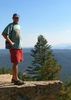
I'd never been up here before and with the clear skies, the views to the Mazzy's and north to a good portion of the rim were spectacular.
[ youtube video ]
[ youtube video ]

Heading down the lookout road I made my way over to some more 2 rack to look for a hole in the ground. The cave was found easily enough. I dropped down in it a bit, knowing that I was not going in too far,being solo. Another time

The next part of my track took me down a draw that I thought would be a bushwhack. I lucked out with old 2 track and game trails. Tall pines and a pretty canyon made the time pass quickly.

I made my turn and headed up Oak Spring Draw. This one was quite a bit slower. Lots of downfall, narrow and much steeper walls. It also had a strangely erie feel to it. As with most of the other areas I'd been in on this hike, there was plenty of bear scat and tracks. The top of this draw, dumps you out to the top of the views from Diamond Rim.

A couple notable items from the return. At the Lookout road, finding a route back into the drainage is a bit tricky. You have to do a bunch of zig zaging to find your way through the crap.

Dropping back down on the rocky 1295, I was shocked to find fresh motorcycle tracks heading down. At every turn I expected that I'd be dialing 911 soon. He made it.

In lieu of making the short, steep, loose climb to the finish, I thought I'd follow a 2 track around hoping it would link up with my parking area. It didn't, so I bailed to a steeper, looser, longer option.

Perfect temps on the day
 Flora
 Flora [ checklist ]
[ checklist ]  Red Devil's Claw
 Named place
 Named place [ checklist ]
[ checklist ]  Wildcat Spring
foliage observationfoliage observationfoliage observationfoliage observationfoliage observation
Autumn Foliage Observation Isolated
some of the Ash has a hint of yellow
wildflower observationwildflower observationwildflower observationwildflower observationwildflower observation
Wildflowers Observation Isolated


water 1 out of 5water 2 out of 5water less than maxwater less than max Wildcat Spring Quart per minute Quart per minute
Spring box is full
_____________________
There is a very fine line between "hobby" and "mental illness."
Dave Barry 🦅
 
May 01 2021
avatar

 Routes 175
 Photos 2,335
 Triplogs 191

44 female
 Joined Jan 21 2019
 Pine, AZ
Preaching fail, AZ 
Preaching fail, AZ
 
Hiking avatar May 01 2021
jillyonanadventureTriplogs 191
Hiking1.39 Miles 167 AEG
Hiking1.39 Miles   1 Hour   9 Mns   1.32 mph
167 ft AEG      6 Mns Break
 
1st trip
Linked   linked  
Partners partners
klfranz
Route Scout Route Recorded  on Route Scout | Pop | Map | Popup | MapDEX
What do you get when you have two chicks who picked two trails the night before and did no research? Lol well, you get a fail but a big adventure...

I had downloaded a couple of tracks for this one since they were inconsistent and I wasn’t sure what was correct. We first attempted to get to the start from the alternate track and that one wasn’t making sense upon arrival. We then switched to the official track and followed a maze of roads and gates to a suuuuper random area where Joe’s track was starting.

We started walking and then saw it was another super steep crazy awful old road we’d need to hike on. We already did that on our prior hike and weren’t feeling it so decided to drop straight into the canyon area then meet back up with the track.

This was going okay at first.... there was even some flow! As we continued it became a bit thicker and then the canyon abruptly ended at a large {dry} waterfall and swimming hole. Ooooops! We looked for bypass options on either side and they were all really sketchy (we did get a ways up one before calling it). We turned back and went back through the canyon, but ultimately decided to bust out some chairs and chill right there by our vehicles instead of giving it another go. We were both pleased with our decision, lol!

Our original target was to find the spring and the underground cave. Will definitely need to research better before another try! P.S. If anyone has the correct route to the spring and the cave and could point me in the right direction, that would be very helpful! TIA!
_____________________
Restless between adventures...
  1 archive
Sep 19 2020
avatar

 Routes 386
 Photos 49
 Triplogs 792

43 female
 Joined Jun 23 2015
 Phoenix, AZ
Preacher Canyon to Wildcat SpringPayson, AZ
Payson, AZ
Hiking avatar Sep 19 2020
emilystardustTriplogs 792
Hiking7.00 Miles 602 AEG
Hiking7.00 Miles
602 ft AEG
 no routesno photosets
1st trip
Linked   none no linked trail guides
Partners none no partners
Started from the other side and went to the spring and explored the cave a bit.
_____________________
 
average hiking speed 2.03 mph

WARNING! Hiking and outdoor related sports can be dangerous. Be responsible and prepare for the trip. Study the area you are entering and plan accordingly. Dress for the current and unexpected weather changes. Take plenty of water. Never go alone. Make an itinerary with your plan(s), route(s), destination(s) and expected return time. Give your itinerary to trusted family and/or friends.

helpcommentissue

end of page marker