username
X
password
register
for free!
help
ArticlesGuidesRoutes
 
Photosets
 
 Comments
triplogs   photosets   labels comments more
Squaw Creek Ruins - 10 members in 20 triplogs have rated this an average 4.3 ( 1 to 5 best )
20 triplogs
login for filter options
Nov 16 2024
avatar

 Guides 25
 Routes 376
 Photos 5,897
 Triplogs 346

40 male
 Joined Mar 01 2018
 Chandler, AZ
Squaw Creek and Brooklyn Ruins, AZ 
Squaw Creek and Brooklyn Ruins, AZ
 
Hiking avatar Nov 16 2024
John10sTriplogs 346
Hiking8.73 Miles 590 AEG
Hiking8.73 Miles   7 Hrs   4 Mns   1.38 mph
590 ft AEG      45 Mns Break
 no routes
1st trip
Linked   linked  
Partners partners
TboneKathy
We'd planned this one back in March, but muddy roads forced a change of plans that day and we explored the Rosalie/Hackberry ruins instead. No issues with road conditions today, and we started near the FR 14/FR 620 intersection and headed south, visiting multiple complexes in the Brooklyn ruins. They're not as overgrown as some of the other sites, and though they seem to get plenty of visitors, there are still some walls in pretty good shape.

We continued south, roughly paralleling the edge of the mesa, and came across a cluster of metates, at least seven obvious grooves and a few more that looked like they were in the early stages of formation. We passed one more small ruin on the way to the large Squaw Creek site and took our time dropping down off the mesa edge where there were breaks in the cliff to explore the many petroglyph panels down there...interesting how the vast majority of the rock art is down below and very little up on the top of the mesa near the ruins.

Around three miles in, Route Scout suffered an error I'd never seen before, and all the saved/downloaded routes disappeared...including the one I was following :(. It continued recording, but all the points of interest I'd mapped were gone, so a well-planned hike turned into a little more exploring. But the main Squaw Creek complex is hard to miss, and it's impressive--lots of rooms, lots of pottery, and many tall walls that are pretty well intact. The location right on the mesa edge is impressive, with great views overlooking the creek.

Next up was the red deer petroglyphs, and we had to search based on landmarks since I was now Scouting Routeless. But we lucked out, and my second attempt at zooming in and scanning the cliffs with the DSLR camera paid off, and a splash of red caught my eye--the big deer, then the smaller one behind it. We made our way down, and I scrambled up for a closer look [ youtube video ] . Very cool and unique petroglyphs, and the color is impressively vibrant. The was a bonus third red deer nearby, though it was a little more faded. I explored further south along the cliffs and found a few more nice panels, then we went back up to the mesa to return to our starting point and hike down toward Brooklyn Mine.

On the way back, TboneKathy spotted another cluster of metates, this time nine of them in close proximity. Surprisingly, there were three vehicles near the Brooklyn ruins and six or seven people walking around. From a distance, it looked like one of the kids was hauling off a handful of something...hopefully it wasn't a Perry Mesa looting field trip. We stopped by a few more ruins we'd missed earlier, then hiked down FR 14 toward the mine. Without the route/waypoints, it would've been a lot of aimless searching, so we just hiked down the road a short distance and checked out a small ruin or two.

Then back up the road and we came across a few more small ruins on the way up to check out a hilltop rock outcropping with a few petroglyph panels. As we finished up, it looked like the Bradshaws were getting hit with rain to the northwest. Another fun day in Agua Fria, and we saw all the main highlights despite the RS issue and pulled off another I-17 miracle with no major delays on the way home. After today, we've now visited six of the seven ancient Perry Mesa cities, with just Lousy Canyon remaining.
 Flora
 Flora [ checklist ]
[ checklist ]  Century Plant
 Fauna
 Fauna [ checklist ]
[ checklist ]  Red-tailed Hawk
 Culture
 Culture [ checklist ]
[ checklist ]  Mining Claim

water 1 out of 5water 2 out of 5water 3 out of 5water less than max South Campbell Tank 51-75% full 51-75% full
 
Mar 27 2024
avatar

 Routes 7
 Photos 240
 Triplogs 19

male
 Joined Nov 24 2023
 Tempe, AZ
Squaw Creek RuinsCamp Verde, AZ
Camp Verde, AZ
Hiking avatar Mar 27 2024
overthehillsfarawaTriplogs 19
Hiking15.40 Miles 866 AEG
Hiking15.40 Miles   6 Hrs   31 Mns   2.36 mph
866 ft AEG10 LBS Pack
 
1st trip
Linked   none no linked trail guides
Partners partners
LoMein
Bloody Basin road was soft and muddy awhile after entering the mesa, until we reached a puddle large enough and muddy enough that we reassessed our options. We decided to park 3.5 miles from Brooklyn Basin and hike it. Not long after starting, 2 jeeps came through the puddle just behind us but got no further before bailing for something else, but we marched on. Travel was easier off the road so we spent most of the day in soft, prairie-like grassland, with only the occasional cactus to sidestep. Ran across a decent amount of trash and packed some of it out, particularly shotgun shells which I found 5 or 6.
Our plan was to hike south on top of the mesa down to Squaw Creek, then drop down to the ravine and come back north, hitting Brooklyn Basin on the way out. Nice scenery and pleasant hiking, uneventful other than a tree holding a large nest 3-4 feet across. Many of the ruins sites in the area have multiple buildings, and the size is impressive. An aerial view would be best since the ruins are all sprawling with many many rooms, but the walls are unfortunately mostly low rubble. We began to see metates and occasional petroglyphs as we approached Squaw. There were also countless pottery sherds everywhere, all around.
It seems any ruin in the area almost certainly has incredible petroglyphs just over the edge of the cliff its on. I forgot to look for the red deer though I had marked the location, and got caught up in all the awesome petroglyphs we were finding on the east cliff side. Minimal scrambling involved, but some unfortunate cactus locations and bushes with terrible thorns. You could spend all day finding petroglyphs along the canyon wall. I eventually stopped taking pictures of every single one because there were just so many, particularly deer. Most interesting finds were one panel of LOTS of deer, a panel with what appeared to be a duck and a lot of pecked dots, and some of the anthromorphs. Also one that looks X-rated but could be natural rock coloring...
We could see Squaw Creek down below running pretty heavy, coupled with the time we decided to forego dropping down into the canyon and headed back the way we came. We had only a little time upon reaching Brooklyn Basin, one of us explored the ruins and the other poked around the cliffside to find some last petroglyphs. I also made it up the hill near Brooklyn Basin with white rocks on top, but didn't have the necessary time to explore it properly and just found a few glyphs and continued on.
Very successful day except I forgot the sunscreen in the truck and got burned a little
 
Mar 02 2024
avatar

 Guides 177
 Routes 249
 Photos 10,213
 Triplogs 2,215

74 male
 Joined Feb 12 2002
 Gold Canyon, AZ
Squaw Creek RuinsCamp Verde, AZ
Camp Verde, AZ
Hiking avatar Mar 02 2024
AZLOT69Triplogs 2,215
Hiking9.25 Miles 545 AEG
Hiking9.25 Miles
545 ft AEG
 no routesno photosets
1st trip
Linked   none no linked trail guides
Partners none no partners
Brooklin Basin, Squaw Creek Ruin Loop. Great day exploring, encountered no others. Lots of rock art, huge ruins !
_____________________
It's best for a man to remain silent and be thought a fool, than to open his mouth and remove all doubt.
--Mark Twain
 
Feb 01 2024
avatar

 Guides 41
 Routes 1,626
 Photos 14,983
 Triplogs 2,760

69 male
 Joined Jan 20 2009
 Far NE Phoenix,
Perry Mesa - Squaw Creek Loop, AZ 
Perry Mesa - Squaw Creek Loop, AZ
 
Hiking avatar Feb 01 2024
The_EagleTriplogs 2,760
Hiking17.75 Miles 2,132 AEG
Hiking17.75 Miles   9 Hrs   30 Mns   1.97 mph
2,132 ft AEG      30 Mns Break10 LBS Pack
 
1st trip
Linked   linked  
Partners partners
LindaAnn
Route Scout Route Recorded  on Route Scout | Pop | Map | Popup | MapDEX
I had been looking in this area for a different hike (Still on my to-do list) and stumbled upon a triplog from Terry @Nightstalker and his Harem from 2018. [ triplog ] . This mining area looked interesting and would serve as entertainment for the later half of the loop.

Other things on my agenda included checking out all native artifacts in Hansenville as well as the mining ruins on the way into Squaw Creek, seeing if travel down Squaw Creek was doable, and finishing up with looking for the elusive Red Deer.

We started clockwise down FR14 and jumped into a creek bed. We followed this to a larger-than-expected dam, just downstream from Brooklyn Well. The well did contain plenty of water. There was a pump submerged in the well, hooked to a solar cell, but it did not appear to be working.

We took our time and visited numerous mining and native artifacts on our way to Squaw Creek. The cross-country portion from the last mining ruin to the creek was the most problematic with catclaw, but we dodged most of it.

We both agreed that travel in Squaw Creek was enjoyable with the geology and numerous downclimbs. The 6 miles seemed to tick off quickly. At one point, just downstream from the intersection with the North Fork of Squaw Creek, I stopped to bleed off some of the morning's coffee. I turned around and glanced across the creek and saw some of the best petroglyph panels that we saw on the hike. If not for coffee, we would have missed these.

We continued 0.5 miles past the tramway area and had lunch at the Ontario Mill area. Now it was time to turn around and make the biggest climb of the day. To this point, we'd hiked 10 miles, and Route Scout said we had a total of 300' in AEG. That would change quickly.

At the bottom of the tramway area, we fumbled around and checked out the various mining ruins. All pretty interesting stuff. I was amazed at the effort it must have taken just to get all the bricks out there.

The climb up the path of the tramway started innocently enough. There was an obvious cut. It was steep but very doable... until it wasn't. We could see where the Tramway cable dropped into the canyon. It did not look like something we wanted to attempt, so we traversed along the side hoping to find an easier way in. No luck. Our line kept taking us higher, then straight up to gain the top of the ridge. I can't stress this enough... Do not follow this part of our track. Steep, loose, crumbly rock, prickly vegetation. One slip, and we would have been at the bottom of the canyon... Just not gracefully.

We made our way over to the mines, and I entered one for about 30 or 40 feet. It kept going but was too muddy to go further in.

Next stop, Squaw Creek Ruins. We were both looking forward to some flat walking on top of the Mesa. Halfway there, after Linda assured me that the storm forecasted for the day was a "Cold" storm and therefore there would be no lightning. The light rain started, shortly thereafter, a crack of thunder directly over our heads.

We made it over to the Squaw Creek Ruins in a steady drizzle that turned to hail. We found the Red Deer petroglyph and then headed back. At the ruin site, we encountered our only person on the day. He had just completed a 7-mile walk all the way from Bloody Basin Rd to get to the ruins. He was going to have a long walk back on the same muddy roads to get to his car. He would encounter the steady heavy rains on his way back to his car, which we noticed on the way out; he'd left the driver's window open. We walked the 3 miles on FR 599 back to the jeep. The rain had stopped, but the walk was arduous with 5 lbs of clay attached to each of our feet.

The drive out was another page in the adventure for the day. After the storm had rolled through with probably no more than 0.1" of rain, FR14/9014 was extremely slick. For some reason, Linda got very quiet on the drive out. At one point, she had to drop it into 4-wheel low. It was becoming increasingly hard to keep it straight. We both agreed that if we'd taken the Subaru, there would have been a different outcome for the night.

Note to all: Do not attempt this drive if wet, or it's forecasted to be wet.

A tiring and fun day. Mining stuff, native ruins, petroglyphs, 2 F35's buzzing by following the canyon, thunder, lightning, rain, hail, mud, and some pronghorns in the distance.

My first foray into Hansenville.
 Named place
 Named place [ checklist ]
[ checklist ]  Brooklyn Well
_____________________
There is a very fine line between "hobby" and "mental illness."
Dave Barry 🦅
 
Feb 01 2024
avatar

 Guides 110
 Routes 2,246
 Photos 8,982
 Triplogs 2,600

45 female
 Joined Dec 24 2007
 Ahwatukee, AZ
Perry Mesa-Squaw Creek loop, AZ 
Perry Mesa-Squaw Creek loop, AZ
 
Hiking avatar Feb 01 2024
LindaAnnTriplogs 2,600
Hiking17.44 Miles 2,083 AEG
Hiking17.44 Miles   9 Hrs   30 Mns   1.95 mph
2,083 ft AEG      34 Mns Break
 
1st trip
Linked   linked  
Partners partners
The_Eagle
Route Scout Route Recorded  on Route Scout | Pop | Map | Popup | MapDEX
Bruce put together this loop, and I was game to check it out. The one other person he invited said he was going to be doing other things on Thursday that did NOT involve hiking with Linda & Bruce. Or something like that.

The first 11 miles of dirt road is fine. The next 4 miles require decent clearance. I had one brief moment of thought while driving in that this road would suck if it was wet. But everything was nice and dry, so I didn’t dwell on it. We parked near the intersection of FS 14 & 610 and got started just before 0800, walking east on 14.

We dropped downhill, the east in a wash. Some vegetation to deal with. Before long, we reached a dam, climbed above it, and walked over to Brooklyn Well. Some brand new looking equipment there. Headed south, passing several ruins along the way, then headed over to several mining sites. We spent some time meandering around this general area before dropping into the North Fork of Squaw Creek. Dodged plenty of catclaw.

Headed south in the creek bed. We weren’t sure what to expect, but it was surprisingly fun, which was good, since we spent 6 miles in that creek bed. It was mostly vegetation free. The geology was neat, with a lot of variation. A few areas to downclimb, but we always found a good route. No water for the first 3 or so miles, then lots of pools after that. No difficulty in keeping our feet dry. Found some nice panels of glyphs near the biggest pools of water. Lots of animal tracks in the sand, including a big kitty.

We followed Squaw Creek down to the Ontario Mill area, where we looked around and had lunch. After that, we retraced our steps back up the creek a short distance to the bottom of the old tramway. We spent some time looking around the various sites at the bottom, then headed uphill, attempting to stay in the cut for the tramway. It was choked with sharp vegetation, so we found ourselves frequently detouring steeply uphill. At one point, the tramway route shifted into the wash, which didn’t look great. We veered farther uphill, hoping to reconnect with the route. In hindsight, we should have just stayed with the tramway cut. Instead, we found found ourselves scaling a steep hillside with no real hope of getting back on track. Every rock was loose and crumbly, nothing could be trusted. The soil was loose. Cactus and catclaw everywhere. Up was the only way to go, and gravity did not want us to get there. While short in distance, it took an hour to go half a mile, and was among the most difficult offtrail I’ve done.

Once at the top of the slope, we breathed a sigh of relief, then headed over to the mines at the top of the tramway. We looked around the Devonshire Mine for a few minutes, then headed uphill on a dirt road, finally back on track. Saw two military jets fly overhead, and we managed to get pics of them. Clouds were starting to build by now and were looking gloomy as we reached the top of Perry Mesa. We headed east across the mesa as it started to sprinkle, then some loud rumbles of thunder. The rain was light and brief, but I wasn’t thrilled about the lightning. We found the red deer glyph after some searching. As were returning from the glyph, we saw our only other person of the day, a guy who had hiked in 7 miles of road. After we said our greetings, Bruce and I decided to skip the rest of our Perry Mesa meandering, and instead opted to follow the road straight back to the jeep. Despite the fairly minimal rain, we got a good leg workout with five pounds of wet clay stuck to each shoe.

We got to the jeep right around 1730, and had a very exciting four mile drive through wet clay. It was not fun, but we made it, and were quite thankful we had opted to drive the jeep vs any other vehicles. It will be glorious today when I park the jeep in my driveway and hose all the mud off of it—my neighbor has a nervous breakdown anytime I get dirt in my driveway. Great hike, lots of things to see along the way, overall very fun day. Thanks, Bruce, for the invitation!
 Flora
 Flora [ checklist ]
[ checklist ]  Dudleya
 Geology
 Geology [ checklist ]
[ checklist ]  Dry Falls
wildflower observationwildflower observationwildflower observationwildflower observationwildflower observation
Wildflowers Observation Isolated
Saw two different purple flowers, and one yellow. That’s as much as I know about flowers.
_____________________
Stop crying and just go do the hike.
 
Mar 26 2022
avatar

 Guides 37
 Routes 556
 Photos 10,872
 Triplogs 1,052

43 male
 Joined Jan 21 2013
 AZ
Brooklyn MineCamp Verde, AZ
Camp Verde, AZ
Hiking avatar Mar 26 2022
FOTGTriplogs 1,052
Hiking4.00 Miles 675 AEG
Hiking4.00 Miles   3 Hrs   15 Mns   1.36 mph
675 ft AEG      19 Mns Break
 no routes
1st trip
Linked   linked  
Partners none no partners
I was able to get back out to my winter project again today with Katie and the pups.

Our first stop was a quick return to the Squaw Creek Ruins to show Katie the red deer and the impressive array of glyphs at that site. The red deer was a hit of course and I saw a few more glphys that I did not see the first time. After our traverse of the basalt cliff lines we returned to the car and headed to the scenic South Campbell Tank for the dogs to cool down. We then backtracked to the tip off point for the Brooklyn Mine and the surrounding ruins referred to as the Brooklyn Basin Group in the “Tonto Visitor Guide.”

We parked at the first obvious ruin there and then took some social and cattle trails down to the cliff bands where the glyphs started off slow and then got steadily better as we traversed the base of the basalt cliffs. In fact, there were three very busy and superb panels along the way, to include another red deer. There were some of the most unique abstract glyphs that I have seen in the area as well along with some peculiar animals, very large animals and human figures. After nerding out at the glyphs we headed down to the road and explored some impressive ruins that I had seen in the area on satellite imagery. The ruins ran across a hilltop and ridgeline and offered some of the most defined rooms I have seen on the mesa, as well as a few taller walls for the area. From the ruins, we headed down to the basin area and towards the “chimney.” Several large ruin piles are sprinkled across the area and the juxtaposition with the mining ruins was somewhat thought provoking. We took a break in a nice sliver of shade inside one of the abandoned contemporary buildings and then headed back to the car. One more stop at South Campbell on the way out for the dogs and then it was back to Phoenix. The Monument continues to deliver for me this year. I hope to make it out at least a couple more times before the heat comes.
 Named place
 Named place [ checklist ]
[ checklist ]  South Campbell Tank

water 1 out of 5water 2 out of 5water 3 out of 5water 4 out of 5 South Campbell Tank 76-100% full 76-100% full
water report recorded in the field on our app Route Scout
_____________________
  3 archives
Feb 26 2022
avatar

 Guides 37
 Routes 556
 Photos 10,872
 Triplogs 1,052

43 male
 Joined Jan 21 2013
 AZ
Squaw Creek RuinsCamp Verde, AZ
Camp Verde, AZ
Hiking avatar Feb 26 2022
FOTGTriplogs 1,052
Hiking4.89 Miles 275 AEG
Hiking4.89 Miles   2 Hrs   16 Mns   2.49 mph
275 ft AEG      18 Mns Break
 no routes
1st trip
Linked   none no linked trail guides
Partners none no partners
I finished off a productive winter of exploring the Agua Fria Monument with a trip out to Squaw Creek to see the ruins and the fabled red deer.

I hit the road early in the morning and benefited from a mostly frozen road, however, as I neared the Squaw Creek site the road became pretty muddy and a little soft in spots. As a result, I ended up parking at a campsite, just over a mile from the ruins and walking the final portion of the road in. This is not a road to test in wet conditions. The road was a bit of a pain to walk, as the clay was sticking to my shoes and the dogs' paws, so we paralleled the road at times and then cut cross country on the grass and rocks to avoid the mud. Off-trail travel was actually fairly easy going by monument standards and we ran across a minor dwelling and large grinding area along the way, so that was a plus.

The glphys at this site are superb and some of the nicest for the general area and central Arizona. There are panel after panels of intriguing glpys all along the basalt cliffs below the ruins and they can't be missed. The red deer was as impressive and intriguing as I thought it would be. The actual ruins are some of the nicest within the monument, with a unique outer wall and several discernible rooms sprinkled throughout a massive pile of rubble. Far below the ruins, Squaw Creek was flowing nicely and the mountains to the south provided a pretty stunning backdrop to tour the ruins and view the glphys.

We stopped in the Brooklyn Basin area on the way back and toured a couple of sites. I did not look for any glphys and it was just a quick stop. I will come back in the near future hopefully and explore the Brookyln Basin area some more, as well as take another walk along the basalt cliffs below the Squaw Creek site.

A nice ruin in a terrific setting with some pretty intriguing and unique glpys. I am glad I finally made it out here.
 Culture
 Culture [ checklist ]
[ checklist ]  HAZ - Hike HAZard
 Named place
 Named place [ checklist ]
[ checklist ]  Agua Fria National Monument

water 1 out of 5water 2 out of 5water less than maxwater less than max North Fork Squaw Creek Light flow Light flow
_____________________
 
Jan 30 2020
avatar

 Guides 4
 Routes 52
 Photos 1,303
 Triplogs 75

female
 Joined Feb 04 2017
 Sun City
Squaw Creek RuinsCamp Verde, AZ
Camp Verde, AZ
Hiking avatar Jan 30 2020
caragrueyTriplogs 75
Hiking
Hiking
 no routes
1st trip
Linked   none no linked trail guides
Partners none no partners
I went in search of the elusive "Red Deer" Pictograph and I found 2. One of my friends had been down with a knee injury so I thought maybe something a bit tame. We ventured out not knowing how far my vehicle would manage to go into the unknown to us area. After pausing to chat with the local (cows) we headed in. Not having seen a Pictograph before I had to see the red deer. Knowing my friend couldn't do to much climbing we checked out the glyphs staying on the somewhat paths. But I really needed to see the "red" deer. Just as we decided to head up I found it. And the bonus was I located a smaller one as well.
_____________________
 
Aug 11 2018
avatar

 Routes 12
 Photos 51
 Triplogs 13

37 female
 Joined Jul 11 2018
 Phoenix, AZ
Squaw Creek RuinsCamp Verde, AZ
Camp Verde, AZ
Hiking avatar Aug 11 2018
MandaBearPigTriplogs 13
Hiking5.40 Miles 117 AEG
Hiking5.40 Miles   1 Hour   53 Mns   2.87 mph
117 ft AEG
 
1st trip
Linked   none no linked trail guides
Partners none no partners
As this hike follows a forest service road, it is easy and almost completely flat. The dog and I parked at the gate to 610 and walked in. It had stormed the night before and 610 looked a bit too muddy for driving. Absolutely beautiful walk among the tall grass. By the time we got to the first set of ruins, the dog was pooped (she's still getting acclimated to exercising above sea level!) so I made the decision to turn around rather than push on another .5 mile to the big ruins. Will definitely come back and complete the trail to Silver Creek at some point.
 Fauna
 Fauna [ checklist ]
[ checklist ]  Tarantula
  1 archive
Mar 13 2018
avatar

 Guides 100
 Routes 63
 Photos 2,548
 Triplogs 184

76 male
 Joined Nov 21 2015
 Grand Junction,
Squaw Creek RuinsCamp Verde, AZ
Camp Verde, AZ
Hiking avatar Mar 13 2018
Steph_and_BlakeTriplogs 184
Hiking1.00 Miles 134 AEG
Hiking1.00 Miles   1 Hour      2.00 mph
134 ft AEG      30 Mns Break
 no routes
1st trip
Linked   none no linked trail guides
Partners partners
AZWanderingBear
Enjoyed checking out the ruins and rock art/writing, but we especially liked seeing the painted petroglyphs. I thought it was better than the bear glyph in the Maze, but Blake's still voting for the bear. These ruins were different than others we saw on Perry Mesa in that they were built right up to the edge of the cliff. Also, Wade pointed out that this grouping had an exterior wall around it, while the others do not. As with the other ruins, pieces of pottery were scattered everywhere as well as what appeared to be chipped obsidian. No metates were found.
_____________________
Stephanie and Blake Barnard
 
Feb 10 2018
avatar

 Routes 189
 Photos 7,236
 Triplogs 1,740

57 male
 Joined Apr 25 2011
 Goodyear, AZ
White Mule Gold Mine, AZ 
White Mule Gold Mine, AZ
 
Hiking avatar Feb 10 2018
NightstalkerTriplogs 1,740
Hiking8.00 Miles 1,640 AEG
Hiking8.00 Miles   7 Hrs   32 Mns   2.03 mph
1,640 ft AEG   3 Hrs   36 Mns Break16 LBS Pack
 
1st trip
Linked   linked  
Partners partners
Gallydoll
It’s been a while since I’ve been up to see the Squaw Creek Ruins and petroglyphs. While I knew that my crew of hike regulars would appreciate the ruins and glyphs, they would be expecting something more. I considered stopping by the Brooklyn Mine complex on the way to the ruins, but on a dirt bike ride back in 2009 I stopped by another mining complex that was just beyond the ruins. After some research, I decided we’d park at or near the ruins and go hike a loop to check out the mines and mills south of the ruins.

I was concerned about the condition of the roads leading back to the ruins. Last time I was there, I felt pretty invincible in my Jeep Wrangler. My RAM 3500 is wider, longer, and rougher. I had picked a couple of places to park in case we couldn’t get to the ruins. We left Phoenix at 5:30 which I figured should put us near the ruins just after sunrise. Easy ride up the I-17 to Bloody Basin Road and then 11 miles east on the bladed graded dirt road. Bloody Basin is suitable for just about any passenger vehicle. Turn south (right) at the Aqua Fria kiosk onto what’s listed as 9269 on the AFNM map, but I’m pretty sure the route was signed as FS14. Continue south for 4 miles to the intersection of FS610, turn right and pass through a gate. If you follow FS14, it heads east to the Brooklyn mine complex. This section of road is rougher than Bloody Basin, with some mud holes (which were all dry) and bypasses, but still not all that bad. Once you pass through the gate, the road gets even rougher and slower going and high clearance is required. Go another ½ mile south and bear left onto FS599. 2 more miles south brings you to the FS3164 loop on your left. FS3164 is a whole new world of hurt. I dropped into 4WD Low and proceeded to bounce my guests around the inside of my truck. About half way to the ruins parking area and just over 18 miles from I-17, I called it quits, we parked, and started our hike.

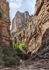
It was 56 degrees when I left my home in Phoenix, it was now 36 degrees, brrr! I knew the chill wouldn’t last long though with sun quickly rising to the east. We made a bee-line west-southwest cross country toward the White Mule Gold Mine complex. The terrain is flat with very little grass or cactus to hamper you. We eventually landed back on FS599 for a bit before taking the easy left on the unmarked road down to the mines. On my last visit in 2009, this road was barely passable on a dirt bike. However, the UTV crowd have now been making their way down to check out the mines. You’re still not going to get a jeep down this road as it’s too narrow. I was preoccupied with finding some foundations and old road to the west as we descended from the top of Perry Mesa. We did find some holes in the ground, possibly collapsed mine shafts, and the two building foundations. The old road or pack trail is shown on the 1930 Topo Map and it is still evident today. Stone walls line the lower side and a game trail works its way through the cactus and palo verde as the trail gently descend to the south. It was pretty easy going until we reached the point where the trail drops off the side of the mesa. The map shows the trail switch backing its way down to Squaw Creek below. We really couldn’t see anything resembling a trail and dropped nearly straight down to a visible building foundation near the creek. It was slow going, route finding, cactus dodging, slipping and sliding, but we made it not too much worse for wear. We spent some time exploring the area known as Ontario Mill. Building foundations, bottles, cans, and tons of turn of the century trash litter the area. An old stage route from Black Canyon City to the Brooklyn Mine complex is visible running through this area as well. From here we headed up stream towards the Golden Eagle mill site. The old stage route disappears into Squaw Creek which was full of vegetation and pools of water.

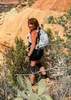
It’s a short ½ mile walk to Golden Eagle. If you look closely on the east side along Squaw Creek, you can see a water pipe that was used to deliver water from Golden Eagle Mill down to Ontario Mill. The Golden Eagle site covers a much larger area. This site had a tram that connected to the mines on the mesa above as well as a stage stop and Post Office. There are red brick structures and older stone/adobe foundations. There is also a large and small cement lined water reservoir. The big attraction for today was the tramway. While almost none of the trestles remain, the foundations are evident, and a steel cable runs almost the entire length! The descent had been a little scary and I wasn’t looking forward to our trek back to the top. My plan had been to follow the old tramway back up and that’s just what we did. The ascent started steep but easy, following the cable and debris of nails, various metal bars and bolts, and railroad spikes. We got to a spot where either a trestle had elevated the tramway over a deep drainage or the canyon wall had washed away over the years. Following the path of least resistance, we dropped into the drainage and found part of a rail car and a stack of rails. We rock hopped our way up the drainage and a super steep and slippery scramble back up to the tramway. This does eventually bring you up to what I believe to be the Devonshire mine, a horizontal shaft that is filled with water. There are some structures and mining equipment from the 1970’s – 1980’s, the last time I believe this claim was worked. From here, you can follow the mine road back up to FS599 on the top of the mesa.

As we short cutted our way across the top of the mesa toward Squaw Creek ruins, I commented that this was the first time I hadn’t seen antelope on the mesa. Not 2 minutes later, a herd of antelope appeared, as if on que, so we wouldn’t be disappointed. The girls were pretty tired out and there wasn’t a whole lot of enthusiasm for checking out the ruins and glyphs, especially with the truck in site in the distance. They reluctantly followed me down over the side of the mesa once more and enjoyed the work of artisans from a thousand years ago.

After 8 hours on the trail, we were spanked. No one was looking forward to the bouncy 75 minute drive back to the I17. But, the thought of pancakes at 50’s Diner Backseat Bar in Cordes Lakes kept everyone going. Unfortunately, they only serve breakfast until 3pm, and we were 90 minutes late. I laid my Nightstalker charm on mighty heavy, but I couldn’t convince our waitress to make just one more stack of pancakes to feed a table of four. I’m sure that tears welled up, but none were shed, we were too tired for that.
 Fauna
 Fauna [ checklist ]
[ checklist ]  Pronghorn
 Culture
 Culture [ checklist ]
[ checklist ]  Mine Shaft
_____________________
 
Mar 09 2016
avatar

 Guides 1
 Routes 259
 Photos 10,458
 Triplogs 293

male
 Joined Jan 28 2010
 Fountain Hills,
Squaw Creek Ruins and ET 1 JEK, AZ 
Squaw Creek Ruins and ET 1 JEK, AZ
 
Hiking avatar Mar 09 2016
FLYING_FLIVERTriplogs 293
Hiking2.84 Miles 225 AEG
Hiking2.84 Miles   4 Hrs   36 Mns   2.30 mph
225 ft AEG   3 Hrs   22 Mns Break
 no routes
1st trip
Linked   linked  
Partners none no partners
This was my first hike on Perry Mesa, so I started out early, not knowing the road conditions on the mesa. I recommend maps, GPS tracks etc, just to get to the correct spot to start your hike, as the many roads on the mesa could really lead you astray.

For my first adventure, I chose a couple ruins that are waaaay south on the mesa. From I-17, it was a slow 18 mile drive to my chosen trailhead, which was about a mile short of Squaw Creek Ruins. (The roads were good enough that I could have driven right to Squaw Creek Ruins, but I wanted to wander around to and from the ruin.)

I visited a smaller ruin on the way to Squaw Creek. As usual, this ruin was very overgrown with vegetation, but the walls were very evident. It’s about 1/2 mile from the huge Squaw Creek ruins.

Even to this ‘ruins rookie’, Squaw Creek Ruins was easy to locate, as the flat, grass filled mesa gives way to a more raised and more dense vegetation representation.
Squaw Creek Ruins is huge, especially when you include the area that encompasses its outer rock walls on its north side. It appears it’s not just a dwelling with multiple rooms, but north of the rooms is a boulder-bordered area bigger than a tennis court, that possibly was used for raising crops or used for ??? (Again, I default to my ‘rookie-isim’).
What ever the function was of the open and cleared area, it had to be purposeful, as the ‘dwellers’ took alot of time and effort to clear it and build the wall.

Pottery sherds must number in the thousands. They’re all over the place, easily visible in that open, cleared area. The ruin is right on the edge of the mesa, with a foreboding boulder wall as its eastern border. The trek down to Squaw Creek for water etc, probably had a well worn path, as all humans don’t last long without water.

The exterior of that eastern boulder wall is where the majority of the petroglyphs were carved.
I trekked along the outer wall and viewed as many as I could locate, including a few that are pigmented in red. There are three “red” deer depicted, with a few other petroglyphs that still display a fading red hue.

Another reason I chose this ruins for my first PM adventure, was because there’s a benchmark inside the ruin. The benchmark’s name is ‘ET 1 JEK’.
(ET = Electronic Traverse, the ‘1’ is the first of a series of 5 benchmarks going east from here, and the ‘JEK’ is more than likely the head-surveyor’s initials). The #5 in this ET JEK series of USGS benchmarks is on W Cedar Mtn, which I located a few weeks ago.

The dusty drive back to I-17 was slow going but uneventful. I expect I’ll venture out on Perry Mesa many more times, as there’s so much to see.

I’m always amazed at how ‘hardy’ the occupants must have been, to handle this southwestern environment through all 12 months of a year. My ‘hat is off’ to all them.
 Culture
 Culture [ checklist ]
[ checklist ]  Benchmark
_____________________
Not All Those Who Wander Are Lost
J.R.R.TOLKIEN
 
Feb 14 2015
avatar

 Guides 4
 Routes 205
 Photos 9,282
 Triplogs 526

72 male
 Joined Apr 06 2005
 Phoenix, AZ
Squaw Creek Loop, AZ 
Squaw Creek Loop, AZ
 
Hiking avatar Feb 14 2015
HansenazTriplogs 526
Hiking10.51 Miles 3,161 AEG
Hiking10.51 Miles   9 Hrs   49 Mns   1.42 mph
3,161 ft AEG   2 Hrs   26 Mns Break
 no routes
1st trip
Linked   linked  
Partners none no partners
I found a low-res map on the internet that shows a dot south of Perry Mesa labeled Squaw Creek Lookout. I've had this map a few years but the other day I spotted it on a satellite picture. That gave me two reasons to drop off the south end of Perry Mesa because I also had filed away a rumor that there were petroglyphs down below the Squaw Creek Ruins.

I knew this wouldn't be too easy...I'd struggled up that steep mesa edge before...but it didn't look that far and I figured I could do it.

I started near Squaw Creek Ruin and dropped off the edge. A good way to go as there are decorated boulders well below the rim that probably few people see. Continued down to N.Squaw Creek then downstream to where Squaw Creek comes in...lots of water coming in there. On my previous trip here I hoped that the pool just up Squaw Creek would show signs of being an ancient hang-out...but no. I did find the hang-out this time further downstream...a really great petroglyph site.

Then it was time to head up to the lookout. In retrospect I picked a bad route. It's steep and unpleasant no matter how you do it but I spent a lot of time climbing and traversing.

The lookout (actually a fort) was very nice. There are quite a few of these in the area but I think this one is the most well preserved. It wasn't easy to get by the big wall blocking access from above. It's a mystery to me why they worried about people coming from that way and also I wonder why it was here To my knowledge all the big villages were on the other side of the creek....I didn't see any pottery or other habitation signs.

On the way down I walked into a group (a dozen or more) of Javelina who startled me with their huffing and showed no sign that they would yield the right-of-way to me. It was particularly steep getting down to the creek here.

I walked up stream for a mile or so (knee deep in water some of the time) to a ridge I followed up to an abandoned mine (passed a small ruin). From there I took the defunct mine road and then the jeep road back to the car.

Much tougher hike than I expected - got back well after dark.
_____________________
 
Mar 30 2013
avatar

 Routes 189
 Photos 7,236
 Triplogs 1,740

57 male
 Joined Apr 25 2011
 Goodyear, AZ
Squaw Creek RuinsCamp Verde, AZ
Camp Verde, AZ
Hiking avatar Mar 30 2013
NightstalkerTriplogs 1,740
Hiking0.40 Miles 150 AEG
Hiking0.40 Miles      53 Mns   0.45 mph
150 ft AEG4 LBS Pack
 
1st trip
Linked   none no linked trail guides
Partners none no partners
My second visit to the ruins. I had forgotten how large the site is and the incredible number of petroglyphs. Took the Jeep the full route to the ruins and it does get a little rough the closer you get to the ruins. It is fun climbing around on the rocks to observe the rock art. Bugs were really bad so remember to take repellent.
_____________________
 
Dec 01 2012
avatar

 Guides 4
 Routes 205
 Photos 9,282
 Triplogs 526

72 male
 Joined Apr 06 2005
 Phoenix, AZ
Brooklyn-Squaw Creek Ruins Loop, AZ 
Brooklyn-Squaw Creek Ruins Loop, AZ
 
Hiking avatar Dec 01 2012
HansenazTriplogs 526
Hiking8.90 Miles
Hiking8.90 Miles   7 Hrs   15 Mns   1.23 mph
 
1st trip
Linked   linked  
Partners none no partners
I wanted to revisit these nice ruins/petroglyph sites, looking for rock art I missed the first time. I also thought it would make a nice loop by descending the creek and returning along the rim of Perry Mesa.

I parked at the Brooklyn ruins and walked up the small hill to the north to the rockpile at top. There were some petroglyphs there and on the boulders at the base. Then I headed south to the jeep road and into the sandy wash. About 1/4 mile down there was a cluster of boulders with faint petroglyphs, a circular arrangement of smaller rocks, and a worn "metate-type" feature. About 45 min later I left the wash to the right and found a larger habitation site (judging by the mainly overgrown extensive ruin walls). I saw a faint glyph and a few pot sherds here.

To this point the wash had been easy going but it started to get steeper with many small drops. They were mainly easy to descend or by-pass, though one caused me some trouble - I had to go quite high to the right and it was hard to get back. Several small pools/puddles were present along the way. The wash intersects N.Squaw Creek and eventually, after turning west far below the south tip of Perry Mesa, Squaw Creek itself. I went a few hundred yards up Squaw Creek to a substantial pool - to my surprise though there were no petroglyphs and little sign the mesa inhabitants spent much time there.

Then came the tough climb up to the mesa rim. Hard to believe this was (probably) the standard path to get a drink of water. I planned to hit a different part of the cliff band than I'd been to before, and thought I had, til I saw the famous Red Deer petroglyph. This oriented me so I went up to the rim, walked through the Squaw Creek Ruins and continued along to the cliff bands further east. There are just a huge number of petoglyphs in this whole area. I was running out of time and getting tired so I just skimmed the easy ones. In some places the hill was very steep (and so difficult to traverse), and the glyphs were high (and difficult to reach). I need to go back again.

From the Squaw Creek Ruins I walked near the mesa edge back to my starting point. Not wanting to trip on the basalt rocks hidden in the shadows in the grass I didn't see much of interest along the way, just one small circle of rocks with some sherds a few hundred yards south of the southernmost Brooklyn ruin.

Another fun day on Perry Mesa...
 Fauna
 Fauna [ checklist ]
[ checklist ]  Red-tailed Hawk
_____________________
 
May 26 2012
avatar

 Guides 4
 Routes 205
 Photos 9,282
 Triplogs 526

72 male
 Joined Apr 06 2005
 Phoenix, AZ
Squaw Creek RuinsCamp Verde, AZ
Camp Verde, AZ
Hiking avatar May 26 2012
HansenazTriplogs 526
Hiking2.40 Miles
Hiking2.40 Miles   2 Hrs      1.20 mph
 
1st trip
Linked   none no linked trail guides
Partners none no partners
It feels like a long drive in on the slow road...it's about 7 miles as the crow flies from the Agua Fria Nat. Monument kiosk at Bloody Basin Rd. to the far rim where Squaw Creek Ruins are located. I made it to within about a mile with moderately high clearance before parking and walking the rest of the way.

The road passes just to the right of a satellite ruin and continues to the main ruin, located right at the edge. It's a magnificent location, perched 1000ft above Squaw Creek. The ruin itself is in better shape than many of the neighboring Perry Mesa ruins, some wall architecture remains, but its still basically an overgrown pile of rubble sticking up above the mesa.

Below the main ruin on the cliff band is a great assortment of petroglyphs including the well known "red deer" glyphs. From the main ruin I descended to the left (east) and then contoured right below the ruin. There is reasonably well worn path and eventually the cliff band breaks up and I climbed back to the rim. I did find the "red deer" though its slightly tricky: when you run into the more obvious "reddish" deer turn around and look up.

I'm sure there are more glyphs and ruins in the area (Dave Wilson's book implies that) but I saw plenty. Though accessible by jeep road I didn't notice any vandalism...I hope it stays that way.
_____________________
 
Dec 12 2010
avatar

 Routes 36
 Photos 2,658
 Triplogs 1,347

67 male
 Joined Jul 28 2004
 Scottsdale, AZ
Squaw Creek RuinsCamp Verde, AZ
Camp Verde, AZ
Hiking avatar Dec 12 2010
mazatzalTriplogs 1,347
Hiking10.00 Miles 800 AEG
Hiking10.00 Miles   5 Hrs      2.00 mph
800 ft AEG
 no routesno photosets
1st trip
Linked   linked  
Partners none no partners
Explored the ruins and petroglyphs at Squaw Creek, Brooklyn group and Silver Creek.
_____________________
  1 archive
Jan 31 2009
avatar

 Guides 14
 Routes 115
 Photos 4,830
 Triplogs 3,536

male
 Joined Oct 29 2005
 Scottsdale, AZ
Squaw Creek RuinsCamp Verde, AZ
Camp Verde, AZ
Hiking avatar Jan 31 2009
topohikerTriplogs 3,536
Hiking2.00 Miles
Hiking2.00 Miles
 no routes
1st trip
Linked   none no linked trail guides
Partners none no partners
We had just seen the Perry Tank Ruins and had a 'little' extra time so we decided to check out the Squaw Creek ruins because we were in the neighborhood. We drove on FR610 to about .2 miles from the unnamed road and started hiking from here. As we went down the unnamed road I saw the satellite ruins, but we didn't have time to check them out. We made it to the ruins and like the Perry Tank ruins, the main attraction is the petroglyphs. Getting to these glyphs was a lot easy and safer than the Perry Tank ones. We were looking for the Red Deer glyph. we seen a bunch of different style glyphs than the other site. We did see a couple of red glyphs, but I don't think we found THE red deer. The sun was dropping so we got out of here and made it back home.
_____________________
"Everywhere is walking distance...If you have the time"
-Stephen Wright
 
Mar 19 2007
avatar

 Guides 4
 Photos 2,750
 Triplogs 402

60 male
 Joined Nov 13 2005
 Cave Creek, AZ
Squaw Creek RuinsCamp Verde, AZ
Camp Verde, AZ
Hiking avatar Mar 19 2007
cabelTriplogs 402
Hiking5.00 Miles
Hiking5.00 Miles   3 Hrs      1.67 mph
 no routesno photosets
1st trip
Linked   none no linked trail guides
Partners none no partners
_____________________
All who wander are not lost...just me.
 
Oct 29 2006
avatar

 Guides 11
 Routes 88
 Photos 2,649
 Triplogs 243

93 male
 Joined May 16 2005
 Scottsdale, AZ
Squaw Creek RuinsCamp Verde, AZ
Camp Verde, AZ
Hiking avatar Oct 29 2006
Al_HikesAZTriplogs 243
Hiking7.00 Miles
Hiking7.00 Miles
 
1st trip
Linked   linked  
Partners none no partners
If you like ruins, petroglyphs and scrambling on boulders, you will like this hike. My friend Tom Kuhn, who writes for Arizona Highways, led a group of 12 of us on an excursion to Perry Mesa. You see a different type of village & tradition when you visit Perry Mesa. I want to especially recognize Gary & Andrea who joined us - they are the stewards for the Arizona Trail Section from Marshall Lake to Fisher Point and they had a very successful trail maintenance last weekend. Lots of hunters out this weekend, but we heard no shots. These rolling plains are great antelope country but we did not see any today.

We started at Pueblo La Plata (Hike 24 Silver Creek in Dave Wilson's book "Hiking Ruins Seldom Seen"). Lots of potsherds on the ground. Went out to the fort. About 2 ¼ miles of hiking. Joes Hill and Cordes Junction USGS topo maps.

Next we went to what Tom calls the Brooklyn Mine petroglyphs. Lots of bouldering. Found a red deer which is rare. Sophia saw a rattlesnake which let us know that they are not yet hibernating. We could see the talings dump for Brooklyn Mine so we hiked to it. I haven't been able to find out much about the history of this mine. Tom thought it was a gold mine, but my research indicates it was a copper mine. Probably started in the 1880's and continued to shortly before WWII. It is not named on the Brooklyn Peak USGS topo map, but is about 2 ½ miles SW of Rosalie Mine. Big bunkhouse that is starting to crumble. Big chimney from what might have been the foreman's house. No abandoned machinery, just an abandoned refrigerator and some box springs.

Next we went to Squaw Creek. (Hike 23 in Dave Wilson's book "Hiking Ruins Seldom Seen"). A big village with very interesting petroglyphs. Found an interesting potsherd with a pattern. The Perry Mesa villagers made unadorned pots, so this pot would have been from some other location. Lots of bouldering to see the petroglyphs, but worth it. On the way we saw a small satellite village, but did not take the time to explore.

Tom took the group to El Pato (Hike 22 Perry Tank Canyon in Dave Wilson's book "Hiking Ruins Seldom Seen"). It is called El Pato because of a petroglyph of a duck. But I had to leave early for a commitment in Tempe.

If you are looking for exercise hiking, this isn't it - look elsewhere. This has a lot of driving for the amount of hiking. And some of the roads are very rough - high clearance required, 4x4 recommended. If the Agua Fria River is running, this hike might not be reachable. But this hike has some very special features that you won't find anywhere else. If you are an aficionado of ruins and petroglyphs, this is a must.
_____________________
Anybody can make a hike harder. The real skill comes in making the hike easier.
life is like a roll of toilet paper. The closer it gets to the end, the faster it goes. Andy Rooney
 
average hiking speed 1.88 mph

WARNING! Hiking and outdoor related sports can be dangerous. Be responsible and prepare for the trip. Study the area you are entering and plan accordingly. Dress for the current and unexpected weather changes. Take plenty of water. Never go alone. Make an itinerary with your plan(s), route(s), destination(s) and expected return time. Give your itinerary to trusted family and/or friends.

helpcommentissue

end of page marker