|
| | | |
| |
|
| Backpack | 11.00 Miles |
400 AEG |
| | Backpack | 11.00 Miles | 3 Days | | |
| 400 ft AEG | | | | |
|
|
| |
| Linked |
|
none
[ show ]
| no linked trail guides |
| Partners |
|
[ show ]
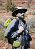
| partners | | Now that the Ankle is Healed up and the Toes fixed so I can wear Shoes again, I've been busy trying to get back in Shape...After losing a little Weight, hitting the Gym, getting quite a bit of Hiking in and some Canyoneering too, it was time to think about Backpacking once more. It's been about 3 Years since I've been and I want to get back into it...
This one has been on my List for a long Time, and it seemed to be a Perfect Fit to get started... Steve mentioned he hadn't been out with a Pack in awhile, so I invited him along... 
The first Day, going in, I was pretty rough around the Edges. We decided to try to keep our Feet Dry going in, and between trying to do that, adjusting to the Pack Weight, and not being totally prepared to keep my Camera dry if I slipped, I was having a hard Time through the first few Creek Crossings. It didn't help that my Confidence is just up from Basement Level after being pretty much off with Injury for over the last Year... But, I had the Foresight to bring Hiking Poles. (A Lesson learned from a Backpack with Alex, when I had to use his for Crutches a few Years ago, due to an IT Band Issue) After I broke out the Poles and figured out a way to Protect the Camera if I went in, I was doing much better, although I just felt a bit Rough and Discombobulated that First Day. Ended up getting my Feet Wet anyway just before we settled in on a Location for Camp... 
Found a nice Spot to Camp next to the Creek and Steve got a small Fire going, and I was able to get my Shoes mostly Dry... Got up the next Morning and Explored Down the Creek some more... There had to have been a Thousand Butterflies around the Water and the Flowers. Most of them were Blues, but there were several other Species as well, just not in the same Numbers... The Blues were in Clusters near Water, Mud and even on the Flowers... If you stepped anywhere near a Cluster, you were immediately Enveloped in Blue as they all took Flight... Between the Water, the Wildflowers and the Wildlife, my Camera stayed extremely busy for the 3 Days. It didn't help that the Area was all New to me either... Steve was a Saint about it, but I probably wouldn't have been Offended if he had Bitch Slapped me a few Times to snap me out of Tibber Mode... 
After a couple of Hours, I decided to Stop in a small Meadow as I wanted to go into Full On Tibber Mode for a while. Steve decided to keep going for a ways and we set a Meet-Up Time to be back at the Meadow for the Return to Camp. After Steve got back from what I will describe as a "glad I didn't go any farther trip", we headed back to Camp, gradually getting there, as I kept running the Camera... Once back in Camp, we decided to take a Swim and although the Water felt great, there were some Blood Thirsty Suckers in that Pool, much to our Surprise... After Stripping down even more and picking a ton of tiny Leeches off of ourselves and each other, we settled back in at Camp with another nice Fire... Not quite the HAZfest Standard Fire, but it was Perfect for getting the Clothes dry...
Got up the next Morning, packed up, and started Heading for the Escape. As we got closer, the people started to be Noticeable, so we decided to take a different Route on the other side of the Creek. That worked out extremely well and we avoided most of the Masses where the Creek was more Accessible. Back to the Vehicle and a late Lunch in Payson before heading to the Barn...
Perfect Choice for a Rusty Backpacker with Confidence Issues. Got things Ironed Out, figured out what to do different next Time and even though there wasn't always a Trail of some kind or another, it was an Easy Trip all around... Thanks for joining me Steve! 
I did a Short Video of some the Blue Butterflies along the Water, so here you go.... [ youtube video ] |
|
Autumn Foliage Observation Isolated
The Poison Ivy is starting to turn... |
|
|
Wildflowers Observation Substantial
All kinds of different Wildflowers going right now... |
|
| _____________________
| Life is not a journey to the grave with the intention of arriving safely in a pretty & well preserved body, but rather to skid in broadside, totally worn out & proclaiming, "Wow What a Ride!" |
| | |
|
|
|
 Route Editor